Map of Galactic Plane - improved method
Date: 11 August 2010
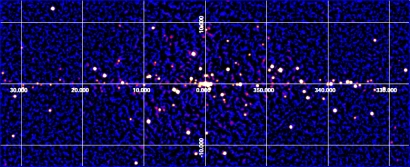
Satellite: INTEGRAL
Depicts: Galactic Plane
Copyright: Krivonos, R., et al., A&A, in press (10.1051/0004-6361/200913814), 2010, reproduced with permission © ESO.
This image is a map of a region near the Galactic Plane, acquired with IBIS/ISGRI on board INTEGRAL, and covering the the 17-60 keV energy band. The total exposure is of about 20 million seconds in the region of the Galactic Centre, the central area of the map.
The image shows the results achieved by using an improved, newly developed algorithm: all strong systematic artefacts mimicking extended structures on the sky are removed with the new method, which returns a much more uniform sky background and highlights the presence of several faint, previously undetected sources.
For comparison, the version of this map created using the previous sky reconstruction method is available from the right-hand menu under "related images".
Last Update: 1 September 2019
