Spacecraft Commissioning Continues
A software upload required before the start of the eclipse season was performed on the spacecraft on 6 February. This operation has had some impact on the collection of scientific data.
The planning of the next few weeks of payload commissioning activities and science operations is ongoing and being prepared with the goal of optimising the scientific return while keeping within the limits of the power budget in a constrained operational environment with eclipses lasting up to 90 minutes per orbit.
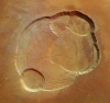
| 18 February 2004 | |
| HRSC - Kasei Vallis The part of the outflow channel seen in this image has most probably been carved by glaciers or gigantic water-related outflows from terrestrial subglacial lakes. The blackish-bluish colour is related to sediments. The bright streaks oriented NE-SW are related to wind forces. |
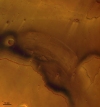 |
| 11 February 2004 | |
| HRSC - Olympus Mons This vertical view shows the complex caldera at the summit of Olympus Mons on Mars, the highest volcano in our Solar System. Olympus Mons stands 24 km tall and the caldera has a depth of about 3 km. |
|
Orbit and Surface Coverage Information
The orbit of the Mars Express spacecraft is very stable. The mapping orbit has been achieved, and the focus of science data acquisition will shortly be extended to global coverage, mosaic and map construction.
The orbit viewer has been recently updated on the Mars Express Internet page, and now shows the precise evolution of the Mars Express orbital configuration around the planet.
The table below shows the orbital parameters for the spacecraft for the coming week.
| Event UTC PERI | Inc | Ecc | Lon Node | Arg Per | SM Axis |
| 040219 07:02:29 | 86.60 | 0.608 | 226.35 | 338.16 | 9327.98 |
| 040219 14:37:08 | 86.60 | 0.608 | 226.33 | 337.97 | 9337.41 |
| 040219 22:11:46 | 86.60 | 0.608 | 226.32 | 337.80 | 9327.99 |
| 040220 05:46:24 | 86.59 | 0.608 | 226.30 | 337.60 | 9334.49 |
| 040220 13:21:13 | 86.57 | 0.608 | 226.27 | 337.45 | 9337.66 |
| 040220 20:55:58 | 86.57 | 0.608 | 226.26 | 337.28 | 9332.11 |
| 040221 04:30:48 | 86.57 | 0.608 | 226.23 | 337.11 | 9343.71 |
| 040221 12:05:40 | 86.56 | 0.608 | 226.21 | 336.99 | 9333.73 |
| 040221 19:40:27 | 86.57 | 0.608 | 226.19 | 336.81 | 9335.25 |
| 040222 03:15:18 | 86.57 | 0.608 | 226.16 | 336.65 | 9339.34 |
| 040222 10:50:01 | 86.58 | 0.608 | 226.14 | 336.49 | 9327.42 |
| 040222 18:24:41 | 86.59 | 0.608 | 226.12 | 336.30 | 9334.65 |
| 040223 01:59:23 | 86.59 | 0.608 | 226.10 | 336.13 | 9328.97 |
| 040223 09:33:58 | 86.60 | 0.608 | 226.08 | 335.94 | 9324.90 |
| 040223 17:08:37 | 86.60 | 0.608 | 226.06 | 335.75 | 9333.92 |
| 040224 00:43:16 | 86.60 | 0.608 | 226.05 | 335.58 | 9324.84 |
| 040224 08:17:54 | 86.59 | 0.608 | 226.02 | 335.38 | 9330.43 |
| 040224 15:52:43 | 86.57 | 0.608 | 226.00 | 335.22 | 9334.32 |
| 040224 23:27:28 | 86.57 | 0.608 | 225.98 | 335.06 | 9328.69 |
| 040225 07:02:17 | 86.57 | 0.608 | 225.96 | 334.88 | 9339.27 |
| 040225 14:37:09 | 86.56 | 0.608 | 225.93 | 334.76 | 9330.64 |
| 040225 22:11:56 | 86.57 | 0.608 | 225.92 | 334.59 | 9331.70 |
| 040226 05:46:48 | 86.57 | 0.608 | 225.89 | 334.42 | 9335.79 |
| 040226 13:21:31 | 86.58 | 0.608 | 225.87 | 334.27 | 9324.37 |
| 040226 20:56:12 | 86.59 | 0.608 | 225.85 | 334.07 | 9331.00 |
| Event UTC PERI = Time of Perihelion Passage yymmdd hh:mm:ss Inc = Inclination (degrees) Ecc = Eccentricity (degrees) Lon Node=Longitude of Ascending Node (degrees) Arg Per = Argument of Pericenter (degrees) SM Axis = Semi-Major Axis (km) | |||||