End of Solar Conjunction Period
After resuming payload operations, the pericentre position in the orbit currently is off by about 1 minute with respect to the frozen orbit prediction. Therefore, it may take up to 2 weeks to get back to the frozen orbit by using nominal wheel off-loadings (no correction manoeuvre is required).
Science Planning Status
Planning for the Medium-Term Plan of October 2004 is now finished. Due to the favourable illumination conditions and latitudes with highly valuable targets, a major share of the scientific data is being given to the imaging instruments. During this period, coverage by the DSN 70m antenna is essential due to the intense scientific activities to be carried out. Pointing requirements for the November period have been delivered, and also include high priority for the various imaging instruments. Preparations for the planning of the second eclipse season (from early January 2005 onward) have started.
Science planning is being carried out without taking MARSIS into account, until another directive is given. Studies on the safe deployment of the radar antenna for the MARSIS experiment are continuing, and expected to be finished and lead to clear conclusions in the last quarter of 2004.
It was decided not to use the opportunity to change the current orbit of Mars Express around day 290. The SWT will establish the programmatic and scientific need to perform such a manoeuvre during the next opportunity for changing the inclination (at day 570), which will still be very effective in modifying the characteristics of the extended mission (eclipse duration and day-night balance).
Science Highlights
Two press releases were recently issued by ESA on two of the Mars Express instrument results
- PFS
New insights into the water and methane distribution in the atmosphere.
Full story at ESA Science Media Centre
ASPERA
The solar wind is found to penetrate the Martian atmosphere down to an altitude of 270 kilometres.
Abstract of article released in Science magazine
Full story at ESA Science Mars Express pages
In addition, the following images taken by the HRSC instrument were released since the last status report:
| 10 September 2004 | |
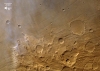
| HRSC - Solis Planum The displayed region is located south of Solis Planum at longitude 271° East and latitude of about 33° South. It shows part of a heavily eroded crater. |
 |
| 27 September 2004 | |
|
HRSC - Ophir Chasma |
 |
| 05 October 2004 | |
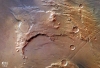
| HRSC - Grabens of Claritas Fossae The displayed region is the eastern part of Claritas Fossae and the western part of Solis Planum at longitude 260° East and latitude of about 28° South, showing the characteristic 'grabens' running mainly north-west to south-east. |
 |