Sixth Close Titan Flyby
16 August 2005
Titan-6 is the sixth close flyby, and seventh targeted encounter of Saturn's largest moon. The flyby occurs on Monday 22 August at 08:54 UTC. The closest approach will be at an altitude of 3669 km above the surface at a speed of 5.9 kms-1. The latitude at closest approach is -59°.The encounter is set up with two approach manoeuvres: an apoapsis manoeuvre (OTM#27) on 10 August and another Titan targeting manoeuvre (OTM #28) on 18 August, four days before the encounter. This Titan flyby encounter will be an outbound flyby, with Saturn periapsis occurring almost two days earlier. The observations will be done using reaction wheels for attitude control.
Science Activities
The Composite Infrared Spectrometer (CIRS) team will control the spacecraft pointing throughout the entire Titan-6 encounter.
- Composite Infrared Spectrometer (CIRS)
CIRS will perform three-dimensional temperature mapping of Titan's atmosphere in longitude, latitude, and altitude. They will also study latitude and altitude variations of the composition, as well as vertical aerosol distribution and surface temperatures. - Imaging Science Subsystem (ISS)
ISS will observe surface features as well as atmospheric and limb-haze properties. - Visual and Infrared Mapping Spectrometer (VIMS)
VIMS will perform medium-resolution mapping, study the haze and mid-latitude clouds and search for changes.
Several of the MAPS teams will continue to gather information on Titan's interaction with Saturn's magnetosphere. In particular, the Titan-6 encounter will allow the study of the wake/tail region on the dayside of Titan.
Table of Events
31 July 2005
| Time UTC | Time wrt Titan-6 |
Event |
| 22:00:00 | T6-21 d11h | Start of sequence s13 which contains Titan-6 |
18 Augustus 2005
| Time UTC | Time wrt Titan-6 |
Event |
| 05:00:00 | -04d 04h | OTM #28 Prime, Titan-6 minus 3 day targeting manoeuvre |
19 Augustus 2005
| Time UTC | Time wrt Titan-6 |
Event |
| 05:00:00 | -03d 04h | OTM #28 Backup |
21 Augustus 2005
| Time UTC | Time wrt Titan-6 |
Event |
| 21:20:00 | -11h 33m | Turn cameras to Titan |
| 21:20:00 | -11h 03m | Deadtime, used to accommodate changes in flyby time |
| 22:05:00 | -10 h48m | Far infrared stare at stratosphere/limb to obtain information on CO2, HCN CH4 |
22 Augustus 2005
| Time UTC | Time wrt Titan-6 |
Event |
| 01:23:00 | -07h 30m | Map the limb in the mid IR; limb photometry. Obtain vertical profiles of temperature |
| 07:16:00 | -01h 37m | Ring plane crossing |
| 08:43:00 | -00h 10m | Scans of south polar region. Study the thermal and compositional structure of Titan's atmosphere. Infrared observations regarding cloud formation and evolution |
| 08:53:37 | +00h 00m | Titan-6 flyby closest approach. Altitude = 3669 km, velocity = 6.0 kms-1, 43° phase |
| 09:00:00 | +00h 07m | Titan wake crossing |
| 09:03:00 | +00h 10m | Slow radial scans. Temperature determination in tropopause and stratosphere |
| 10:08:00 | +01h 15m | Limb stares. Stratospheric studies of compounds - including H20 |
23 Augustus 2005
| Time UTC | Time wrt Titan-6 |
Event |
| 03:27:00 | +18h 34m | Deadtime, used to accommodate changes in flyby time |
| 03:42:00 | +18h 49m | Turn to Earth-Line |
| 04:42:00 | +19h 49m | Begin playback of T6 data to Madrid 70m |
| 13:42:00 | +01d 05h | End playback of T6 data |
29 Augustus 2005
| Time UTC | Time wrt Titan-6 |
Event |
| 11:38:00 | +07d 03h | Saturn apoapse |
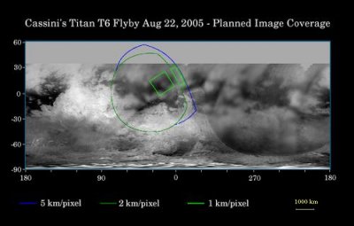
Titan Surface Coverage
 |
|
Credit: NASA/JPL/Space Science Institute |
This map of Titan's surface illustrates the regions that will be imaged by Cassini during the spacecraft's close flyby of Titan on 22 August 2005. At closest approach, the spacecraft is expected to pass approximately 3800 kilometres above the moon's surface. The coloured lines delineate the regions that will be imaged at differing resolutions. Images from this flyby will sharpen the moderate resolution coverage of terrain on the side of Titan that always faces Saturn.
The highest resolution image planned for this encounter will cover a 215-kilometer-wide bright feature provisionally named Bazaruto Facula. (A facula is the name chosen to denote a bright spot on Titan.) At the centre of the facula is an 80-kilometer-wide crater (not yet named), seen by Cassini's radar experiment during a Titan flyby in February 2005 (see also: Impact Crater with Ejecta Blanket). The imaging cameras and visual and infrared mapping spectrometer images taken in March and April 2005 also show this crater.
The southernmost corner of the highest resolution (1 kilometre per pixel) frame should also cover the northern portion of a large bright feature provisionally known as Quivira.
Wide-angle images obtained during this flyby should cover much of the Tsegihi-Aztlan-Quivira region (also known as the H region) at lower resolution.
The above map shows only brightness variations on Titan's surface (the illumination is such that there are no shadows and no shading from topographic variations). Previous observations indicate that, due to Titan's thick, hazy atmosphere, the sizes of surface features that can be resolved are up to five times larger than the actual pixel scale labelled on the map.
The images for this global map were obtained using a narrow-band filter centred at 938 nanometres in the near-infrared, at which light can penetrate Titan's atmosphere. The images have been processed to enhance surface details.
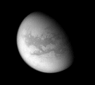
Observation Results
Cassini Instrument: Imaging Science Subsystem (ISS)
|
Date: 25 August 2005 Credit: NASA/JPL/Space Science Institute Image Notes: Titan's surface at mid-latitudes on the Saturn-facing side. Provisional names recently have been applied to a number of features on Titan. |
 |
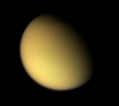
|
Date: 25 August 2005 Credit: NASA/JPL/Space Science Institute Image Notes: Wide-angle camera colour view of Titan, created from images obtained on the inbound leg using red, green and blue filters. |
 |
