Observing the Moon around Impact
The details of the Moon features stated in the roadmap are given further down this page. When you are also taking images, it is useful to take images of the different features along the way, as these can be used for calibration.
Roadmap for Telescope Pointing
| To verify pointing to locations on the Sunlit Moon | ||||
| Tycho CP | |
Bullialdus central peak (CP). Follow the bright Tycho ray to (RA,DEC) = (North,East) towards terminator | ||
| Tycho CP | |
Dunthorne | Dunthorne D [≥3m telescope] | |
| To go from Sunlit to Earthshine-lit Moon | ||||
| Dunthorne D | |
Vitello B | |
Clausius |
| Dunthorne D | |
Vitello B | |
Lehmann C (if albedo Clausius too low in Earthshine) |
| Dunthorne D | |
Vitello B | |
Drebbel D (if albedo Clausius too low in Earthshine) |
| To check pointing accuracy in Earth-shine lit Moon | ||||||||
| Lehmann C | |
Drebbel D | |
Clausius | |
S1C-R | ||
| Lehmann C | |
Drebbel D | |
Clausius | |
Clausius E | |
S1C-R |
| Lehmann C | |
S1C-R | ||||||
Roadmap and Lunar Phase
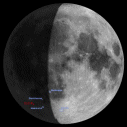
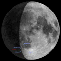
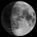
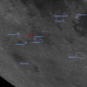
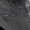
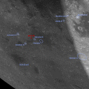
The below set of images shows the phase of the Moon at 3 times: one day before impact, at the time of perilune on the forelast orbit and on the nominal impact time. For the same 3 times, a close-up view of the region around the impact site is also given with the features from the above roadmap labelled. Click on image for the high-resolution version.
 |
 |
 |
 |
 |
 |
|
02-09-2006, 05:42 UT |
03-09-2006, 00:38 UT |
03-09-2006, 05:42 UT |
Calibration
Images: To calibrate images, use mineralogy calibration targets. A list of mineralogy calibration craters is given in the table below. Measurements through various filters are useful (for instance at 400, 450, 500, 550, 750, 900, 950, 1000 nm) or in infrared if you have that possibility.
Spectra: To calibrate spectra, use locations of known or well studied mineralogy.
Location and Description of Moon Features
| Moon Location or Crater |
Description | Additional notes | Light (*) |
Lunar Coordinates | |
| long (°) | lat (°) | ||||
| S1C-R 05:41 UT |
Smart-1 Crash Site Revised 6 Aug. 2006 | above U-shape lunar feature | E | 46.25 W | 36.44 S |
| S1C-OB 00:36 UT |
Orbit Before | North rim Clausius | E | 43.5 W | 36.4 S |
| S1C-2OB 19:31 UT |
2 Orbits Before | E | 41.8 W | 36.4 S | |
| S1C-OA 10:46 UT |
Orbit After | 2° North of Clausius D | E | 49.0 W | 36.3 S |
| Earthshine-lit Pointing Checks, Offsetting to S1C-R | |||||
| Clausius | med albedo circular crater, E of S1C-R | fresh basalt ring, easily recognized at Full Moon | E | 43.8 W | 36.9 S |
| Clausius E | tiny crater NE of U-feature, NW of Clausius | tiny named crater closest to S1C-R | E | 45.5 W | 36.4 S |
| Drebbel D | high albedo craterlet, W of S1C-R | fresh highland | E | 49.3 W | 37.9 S |
| Lehmann C | high albedo crater, NW of S1C-R | fresh highland | E | 50.1 W | 35.5 S |
| Bright Moon Pointing Checks | |||||
| Tycho CP | Tycho crater central peak (CP) | S | 11.2 W | 43.3 S | |
| Dunthorne | bright med. size crater | S | 31.6 W | 30.1 S | |
| Dunthorne D | small crater close to terminator | S | 34.0 W | 30.0 S | |
| Hainzel A | Northern crater of group of 3, use central peak |
different shape, crater has collapsed terraces |
S | 33.9 W | 40.3 S |
| Mineralogy Calibration Craters | |||||
| Campanus CP | med. round crater with central peak | S | 27.8 W | 28.0 S | |
| Copernicus CP | med. round crater with central peak | NIR pyroxene band (Warell et al. 2006) | S | 20.0 W | 09.7 N |
| Apollo 16 | offset from Dollond | soil known | S | 15.5 E | 09.0 S |
| Dollond | circular crater near Apollo 16 | offset to Apollo 16 from Dollond | S | 14.4 E | 10.4 S |
| Apollo 14 | soil known | S | 17.5 W | 03.7 S | |
| Clausius | crater near S1C-R | fresh basalt | E | 43.8 W | 36.9 S |
| Lehmann C | small high albedo crater, NW of S1C-R | fresh highland | E | 50.1 W | 35.5 S |
* Illumination at time of impact: E=Earthshine, S=Sunlight
Note: in this table NW in Lunar Coordinates equals NE in Right Ascension (+) and Declination (+)
Note: Near S1C-R, a pointing change of 0°W, 0.1°S on the lunar surface equals (RA, DEC)=(0.12" E, 1.0" S)
General Information
When looking at maps, remember that:
- Clementine maps show the S1C-R position, and VLO maps show relative crater locations and names in the region of S1C-R
- Virtual Moon Atlas (VMA/AVL) maps are "as seen" in (RA, DEC) on the sky, lunar coordinates projected onto the sky
- Clementine maps are "as seen" in lunar coordinates, in nadir view. This means a circular crater on a Clementine map may look elongated with a Position Angle≠0 when you observe the Moon
- The Lacus Excellentiae region is illuminated until 20 August, and then after impact from 4 September
Contacts
Bernard H. Foing
ESA SMART-1 Project scientist
Bernard.Foing esa.int
Diane Wooden
NASA Ames Research Centre
Impact observer at Hawaii IRTF
Detlef Koschny
SMART-1 campaign amateur astronomer coordination