Antarctic Region

Date: 13 November 2007
Satellite: Rosetta
Depicts: Earth's Antarctic region
Copyright: ESA
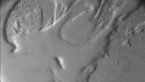
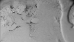
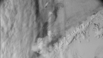
Composite of three images taken by one of Rosetta's two navigation cameras between 20:54 and 20:56 UTC on 13 November 2007, showing the Antarctic region with the northern tip of the Graham Land peninsula in the left half of the composite. See related images, in the right-hand menu, for an annotated close-up of Graham Land and for the three individual images used in the composite.
The images were obtained during the second Earth swing-by from heights of between 5415 and 5500 km. The Sun is to the left in this view. Rosetta's travel direction is also to the left, with the three images taken at ~1 minute intervals from right to left. The composite image is centred at 64.87°S, 53.04°W.
Last Update: 1 September 2019
