Venus Express coverage of Venus (3 February to 2 March 2013)
Date: 07 June 2013
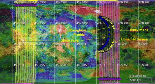
Satellite: Venus Express
Depicts: Coverage of Venus during medium term plan #89
Copyright: ESA
This figure shows coverage of Venus by orbital tracks during the reporting period from 3 February until 2 March 2013 (medium term plan (MTP) 89). The sequence of lines to the left shows the ascending branches of the orbits. The sequence of lines to the right shows the descending branches. The purple colour indicates that the spacecraft is in darkness; the yellow colour indicates that the spacecraft is in sunlight. The position of the terminator - the dividing line between the day and night sides of the planet - corresponds to the last orbit of this MTP. Purple triangles along the top are the pericentre locations (on left, at the top of the ascending branches) and along the bottom are the apocentre locations (on right, at the bottom of the descending branches). Yellow triangles denote start and end of solar eclipses; blue triangles denote beginning and end of Earth occultations.
The surface mapping campaign, begun during the previous reporting period, continued with the following regions being observed:
- Ishtar Terra (55° - 75°N, 310° - 60°E)
- Bell Regio area (e.g. Tepev Mons), (27° - 37°N, 44° - 52°E)
- E. Eistla Regio (10° - 20°N, 36° - 52°E)
- Bereghinia Planitia (28°E, 39°N)
- Oshun Farra (4.2°N, 9.3°N)
- Dzalarhons Mons (0.5°N, 34°E)
- Un-named Tessera (4°S - 4°N, 36° - 46°E).