Martian Surface
What is it made from?
 |
|
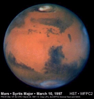
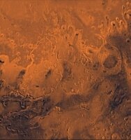
Sharp image of Mars taken with the Hubble Space Telescope showing the dark and light regions. |
The Romans named the planet Mars after their god of war because its colour reminded them of the blood shed on the battlefield. Mars, like blood, derives its red colour from oxidised iron. Haemoglobin carries oxygen bound to iron in the blood, whereas dust, soil and rock rich in oxidised iron give Mars its reddish hue.
If you look at Mars through an Earth-bound telescope - or take a glance at some Hubble Space Telescope pictures of the planet - you'll notice that some areas are brighter than others. By looking at the wavelength of sunlight absorbed and re-emitted by different areas, astronomers have known for some time that the difference in brightness coincides with differences in the way in which iron is bound up in the surface materials. Bright areas are rich in heavily oxidised iron minerals and dark areas contain unoxidised iron bearing minerals.
Dust is a smokescreen
 |
|
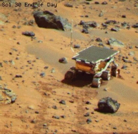
Sojourner rover on Mars. Sojourner carried a European-built instrument for analysing soil and rock samples. |
Appearances, however, can be deceptive - and Mars is no exception. The nature of the surface seen from a distance reveals little about the composition of the underlying rock because the planet is covered with dust, the product of billions of years of erosion by the Martian wind. In some places, rock is exposed, but in others wind-blown dust has masked underlying features. Near the north pole, for example, the dust has been blown into dunes.
Our knowledge of the composition of the underlying Martian surface took a leap forward in 1997 when NASA's Pathfinder spacecraft landed in the Xanthe Terra region of the northern hemisphere. On board Sojourner, Pathfinder's small rover, was the first instrument to land on Mars capable of analysing soil and rocks in situ.
 |
|
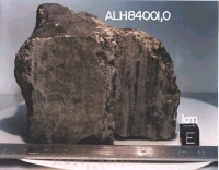
ALH84001, the famous martian meteorite that is made from 'mafic' type rock. |
"Before the Pathfinder mission there was a general consensus that the Martian surface is very mafic (made from volcanic lava) like the Martian meteorites. But the first measurements by Pathfinder showed that the rocks are felsic (containing the whitish mineral feldspar), rather like the Earth's continental crust," says Heinrich Wänke, from the Max Planck Insitut für Chemie, Mainz, the institute where the APX-spectrometer on board Sojourner was designed and built. Mafic rocks are high in magnesium and iron and are thought to derive from pristine mantle material; felsic rocks are rich in silicates, potassium and sulphur but low in magnesium and are thought to derive from rock that has undergone subsequent processing since the planet's formation.
Two types of rock emerge
Taking into account evidence from the Martian meteorites, Pathfinder and observations from orbiting spacecraft, planetary scientists have deduced that the low lying plains in the northern hemisphere are felsic and the ancient highlands in the southern hemisphere are mainly mafic in composition. This division corresponds well with a relatively recent volcanic origin for the northern lowlands and the existence of an ancient, primordial crust in the south. Recent spectral analyses of light reflected from Martian soil and dust reveals that it is made from a mixture of small grains of the two types of rock roughly in proportion to their prevalence in the underlying surface.
 |
|
Dust covers everything. Mars Global Surveyor image of a global dust storm in 1997 (NASA/JPL/Malin Space Science Systems). |
Space missions so far have given us the general picture. The next step is to map the surface composition of Mars with far greater accuracy. "We want to know the iron content of the surface, the oxidation level of the iron, the hydration of the rocks and clay minerals, the types of silicates present and the abundance of non-silicate materials such as carbonates and nitrates," says Jean-Pierre Bibring from the Institut d'Astrophysique Spatiale, Orsay, France, who is Principal Investigator for the Infrared Mapping Spectrometer (OMEGA), which flies on board Mars Express. OMEGA with the help of two other Mars Express instruments, the HRSC and MARSIS, will map the composition of the Martian surface to this level of detail.
Morphology & Erosion
 |
|
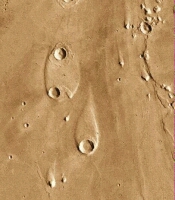
Chryse outflow channel |
Discharge rates have been estimated at 10 000 times the average discharge of the Earth's largest rivers, such as the Mississippi, and 100 times the peak discharge of the largest known flood on Earth. This occurred in the Scablands region of the north-west US about 10 000 years ago when a dam made from ice melted suddenly to release a vast amount of water from Lake Missoula. "The resemblance between the Lake Missoula floods and the Martian outflow channels is quite striking," according to Michael Carr from the US Geological Survey in his book 'Water on Mars'*.
Some outflow channels, such as those to the east of the Valles Marineris, seem to have occurred, like the flood in the Scablands, when the containment around a lake was breached suddenly. But others emerge from regions where the ground seems to have collapsed downwards leaving a jumble of large blocks of rock. "These areas of chaotic terrain are the source of many of the outflow channels. They are huge collapsed fissures in the ground, which are much bigger than comparable features on Earth" says Costard. Vast volumes of fast flowing fluid created streamlined islands like these in the Chryse Basin.
 |
|
Vast volumes of fast flowing fluid created streamlined islands like these in the Chryse Basin |
Comparison with similar features on Earth, is revealing. Areas of chaotic terrain in Siberia formed when ice filling the spaces in the upper layer of rock and soil melted suddenly, causing the rock to fracture and collapse. On Mars, the ground ice must have trapped a large quantity of water in an underground aquifer at very high pressure. The water would have been released when the ground ice melted suddenly, perhaps when the temperature of the atmosphere increased. But a warm climate isn't essential. Other, more likely mechanisms are the heat generated by an impact, volcanic eruption or sudden underground heating of the aquifer. Several of these mechanisms may account for different floods, which seem to have occurred episodically over a span of more than 2 billion years. "Events occurring before 3.8 billion years ago didn't involve ground ice. But after that time, ground ice became important" says Costard.
*'Water on Mars', Michael H. Carr, 1996, Oxford University
Polar Caps
Clues to climate history
In 1666, Gian Domenico Cassini, the Italian-French astronomer, first observed how the white poles of Mars wax and wane with the planet's seasons. He assumed they were covered by water ice like the Earth's poles. Now we know that frozen carbon dioxide is also present and that an unusual area of what is called "layered terrain" surrounds both poles.
The two poles, though, are far from identical. The residual cap at the north pole - the cap left in summer after the winter deposits have melted - is larger than that in the south, but the area of layered terrain is smaller. Sand dune fields, which surround the layered terrain at both poles, are more extensive in the north. The north residual cap consists almost entirely of water ice, whereas frozen carbon dioxide seems to predominate in the south. During winter, both poles expand enormously in surface area and consist of frozen water and carbon dioxide.
 |
|
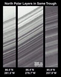
Three images showing layers at the north pole (NASA/JPL/Malin Space Science Systems) |
The polar layered terrains are thought to hold the key to understanding Mars's climate history. "At the south and north pole, the layers are a few tens or hundreds of metres thick. And it's quite evident that they alternate - light and dark. This layering is due to wind blown debris and sedimentation for sure," says Gian Gabriele Ori from the Universita d'Annunzio, Pescara, Italy and a Co-Investigator on the Mars Express High Resolution Stereo Camera.
Each season, freezing water and carbon dioxide trap wind blown dust and other debris at the poles. Gradually, layers are built up that preserve a record of water, carbon dioxide and dust over timescales ranging from seasonal to millions of years. Both polar regions are considerably higher than the surrounding areas, lending support to the notion that they are made of layered terrain deposited over aeons.
The extension of the layered terrains beyond the present residual polar caps suggests that the poles have moved over time, which is not surprising as the inclination of Mars's axis of rotation varies cyclically over thousands of years. Cyclical variations in the shape of Mars's orbit around the Sun also affect the climate, which influences the growth of layered deposits.
 |
|
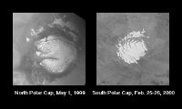
Images of the residual polar caps taken by the Mars Orbiter Camera on board NASA's Mars Global Surveyor spacecraft. |
"No-one knows why the layered terrain in the south is larger than in the north," says Ori. "But if an ocean was once present in the northern hemisphere, it could have limited the extent of the polar deposits there." Another piece of circumstantial evidence for an ocean is the extensive sand dune field around the northern layered terrain. "Sand is a component of the sediment on the ocean floor. The fact that there is a lot of sand in the north is supporting evidence for an ocean there at some time," says Ori.
These uncertainties will be resolved only when better data is returned on the topography and physical appearance of the polar regions. Mars Global Surveyor has been sending back the data since the late 1990s and now the OMEGA and HRSC instruments on Mars Express are helping to build up an even clearer picture.
