First spectacular results from Mars Express
19 January 2004
ESA's Mars Express, successfully inserted into orbit around Mars on 25 December 2003, is about to reach its final operating orbit above the poles of the Red Planet. The scientific investigation has just started and the first results already look very promising.Although the seven scientific instruments on board Mars Express are still undergoing a thorough calibration phase, they have already started collecting amazing results. The first high-resolution images and spectra of Mars have already been acquired.
This first spectacular stereoscopic colour picture was taken on 14 January 2004 by ESA's Mars Express satellite from 275 km above the surface of Mars by the High Resolution Stereo Camera (HRSC).
|
|
|
Image of a portion of Valles Marineris taken with the HRSC |
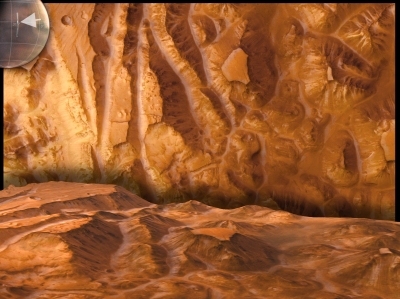
The picture shows a portion of a 1700 km long and 65 km wide swath which was taken in south-north direction across the Grand Canyon of Mars (Valles Marineris). It is the first image of this size that shows the surface of Mars in high resolution (12 metres per pixel), in colour, and in 3D. The total area of the image on the Martian surface (top left corner) corresponds to 120 000 km². The lower part of the picture shows the same region in perspective view as if seen from a low-flying aircraft. This perspective view was generated on a computer from the original image data. One looks at a landscape which has been predominantly shaped by the erosional action of water. Millions of cubic kilometres of rock have been removed, and the surface features seen now such as mountain ranges, valleys, and mesas, have been formed.
