Crater on Asteroid Vesta
 Depicts: Vesta
Copyright: Ben Zellner (Georgia Southern University), Peter Thomas (Cornell University), NASA
Show in archive: true
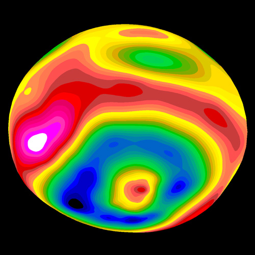
A color-encoded elevation map of Vesta clearly shows the giant 285-
mile diameter impact basin and "bull's-eye" central peak. The map was
constructed from 78 Wide Field Planetary Camera 2 pictures. Surface
topography was estimated by noting irregularities along the limb and
at the terminator (day/night boundary) where shadows are enhanced by
the low Sun angle.
Depicts: Vesta
Copyright: Ben Zellner (Georgia Southern University), Peter Thomas (Cornell University), NASA
Show in archive: true
A color-encoded elevation map of Vesta clearly shows the giant 285-
mile diameter impact basin and "bull's-eye" central peak. The map was
constructed from 78 Wide Field Planetary Camera 2 pictures. Surface
topography was estimated by noting irregularities along the limb and
at the terminator (day/night boundary) where shadows are enhanced by
the low Sun angle.
Last Update: 1 September 2019