SMART-1 Impact Site Visibility from Earth
The best lunar topographic maps currently available are based on data from the US Clementine mission in 1994. The laser altimeter experiment (LIDAR) on board provided the spacecraft altitude over a grid with roughly 1 kilometre intervals. The values in between have been interpolated by the SMART-1 experts, assuming there are no peaks.
During SMART-1's last orbits, the perilune altitude naturally decreases by about one kilometre per orbit. This means that, if encountering unknown peaks in the terrain between one and two kilometres high, SMART-1 may hit ground one orbit or even two orbits earlier than the nominal impact orbit.
Impact Visibility
|
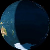
If the impact occurs nominally on 3 September 2006 at 05:41 UT, observers from North and South America and the East Pacific will be able to see the impact or listen to its radio signal during night time, with best views from America's west coast as well as from Hawaii and the East Pacific. Image 1: View of Earth from the Moon at SMART-1's nominal impact time |
 |
|
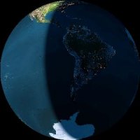
If the probe impacts one orbit before the nominal one, on 3 September at 00:36 UT, the impact will be easily visible from South America, Canary Islands (Spain) and the US East coast, and from radio observatories from the US in daylight. Image 2: View of Earth from the Moon on 3 September 2006, 00:36 UT |
 |
|
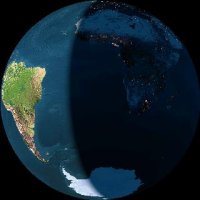
Should the impact occur on 2 September 2006 at 19:33 UT, two orbits before the nominal one, then Africa and South Europe will have a clear view just after sunset. Radio observatories from South America can listen to SMART-1's final signal in daylight. Image 3: View of Earth from the Moon on 2 September 2006, 19:33 UT |
 |
