Mars Express explores the roots of Martian volcanoes
26 April 2012
Recent analysis of radio signals sent back by ESA's Mars Express orbiter has enabled a team of Belgian and German scientists to probe deep beneath the surface of Mars. The first targeted, high resolution measurements of Martian gravity provide new insights into the formation of the planet's massive volcanoes.A great deal has been learned about the surface of Mars over the last half century, primarily through data returned by orbiting spacecraft and automated rovers. These surveys have enabled scientists to study the processes that are shaping the Mars of today.
Some information about the planet's evolution over time has been obtained by chemical analysis of rock outcrops and studying variations in crater density. However, for a more detailed reconstruction of the planet's history it is necessary to probe much deeper. Many of the tell-tale clues about ancient Mars can only be retrieved through ground-penetrating radars and measurements of gravity anomalies.
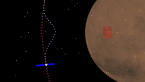
| Mars Express Radio Experiment (MaRS). Credit: Royal Observatory of Belgium. Click here for video details. |
Detection of regions which have a higher or lower gravitational pull than average is achieved by measuring with great accuracy any changes in the motion of an orbiting spacecraft. The tiny variations in its velocity are caused by differences in the density of subsurface material on Mars.
These orbital perturbations can be determined by measuring the Doppler effect - a small extra variation in the frequency shift of the spacecraft's radio signal which is induced by perturbations in the motion of the orbiter with respect to Earth. This was the principle behind the gravity measurements, which were made between 2004 and 2009, as part of the Mars Express Radio Science Experiment (MaRS).
The global gravity field has previously been mapped by studying Doppler shifts in the signals sent back by various orbiters. In contrast, Mars Express followed a very eccentric, near polar trajectory, which brought it within about 270 km of the surface. These close encounters provided limited windows of opportunity to study the gravity signatures of specific regions and landforms with much higher resolution than usual.
"The gravity measurements must be performed when the spacecraft makes a pericentre pass above the target area," said Martin Pätzold from the University of Cologne, Principal Investigator for the MaRS experiment. "During this observational window, the fixed antenna had to be pointed toward Earth, preventing simultaneous observations by other instruments. Negotiating the observation times within the Mars Express Science Working Team was quite a challenge."
"We were able to pinpoint specific targets for study, particularly the major volcanoes and the Valles Marineris canyon system," said Mikael Beuthe, a researcher at the Royal Observatory of Belgium and lead author of the paper.
"Using data from multiple orbits, we were able to reconstruct the perturbations on the spacecraft with very high precision. These were the first detailed gravity observations of specific targets ever made on Mars. They were only made possible by studying the Doppler shifts when Mars Express was passing over the target areas at the lowest point of its orbit, and by analysing data obtained over a period of six years.
"By combining the regional MaRS data and global data from Mars Reconnaissance Orbiter, we could then attempt to model the relationship between the gravity signals, the local topography and the density of surface material."
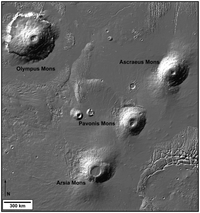 |
| Tharsis Montes trio and Olympus Mons. Credit: NASA
|
One major focus of the team's study was the Tharsis bulge, a 7 km high plateau which covers one fifth of the planet. Towering above this enormous volcanic rise are the three Tharsis Montes, which lie in a row. Nearby is Olympus Mons, the highest mountain in the Solar System, which probably had a similar origin to the Tharsis volcanoes.
Unfortunately, radars cannot penetrate volcanic flows and the rugged area is inaccessible to rovers, leaving gravity anomalies as the only available data on the nature of the subsurface. The MaRS experiment acquired gravity data above the Tharsis volcanoes during dozens of overpasses. The strength of the signal showed that the overall density of the volcanoes is higher than the expected density of the Martian crust, indicative of a basaltic lava composition.
More local detail on the density contrasts was obtained by spectral analysis of the gravity signal. This suggests that, with the exception of Ascraeus Mons, the lower layers of the volcanoes are comprised of andesitic lava, which was subsequently buried under basaltic lava of higher density.
In contrast, the upper part of Ascraeus Mons is made of lower density material, indicating that the density of the extruded lava decreased at a later stage in its evolution. This supports the theory that, if the Tharsis Montes were built in succession by a unique, migrating mantle plume, Ascraeus Mons was probably the last to form.
The data also show that all of the volcanoes, with the exception of Olympus Mons, are underlain by roots of high density material, probably intrusions of magma. The absence of such a root below Olympus Mons indicates that it was built on a highly rigid crust (or lithosphere), whereas the other massive volcanoes partly sank within a less rigid lithosphere. This surprising result suggests large variations of the heat flux in the underlying mantle when Olympus Mons and the other volcanoes were forming.
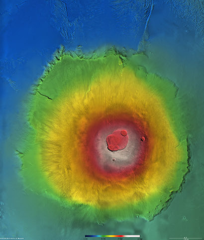 |
| Olympus Mons topography. Credit: ESA/DLR/FU Berlin (G. Neukum)
|
Alternatively, the high density roots could be explained by igneous intrusions within a lithosphere of high rigidity, which led to the formation of underground magma chambers, whereas the magma chamber of Olympus Mons may reside within the volcano itself.
"Both scenarios are difficult to explain, since all of the volcanoes probably formed 3.6 billion years ago, when the heat flux coming from the mantle was much higher and the lithosphere consequently much softer," said Veronique Dehant from the Royal Observatory of Belgium, a co-author of the paper.
"This research shows the fundamental nature of geophysical data in our understanding of the planet's geological evolution," said Olivier Witasse, Mars Express Project Scientist.
Related publication
M. Beuthe, S. Le Maistre, P. Rosenblatt, M. Pätzold and V. Dehant (4 April 2012), Density and lithospheric thickness of the Tharsis Province from MEX MaRS and MRO gravity data, J. Geophys. Res., 117, E04002, doi:10.1029/2011JE003976.
Contacts
Mikael Beuthe
Royal Observatory of Belgium
3 avenue Circulaire
B-1180 Brussels
Belgium
Email: mikael.beuthe oma.be
Phone: +32 2 373 6771
Veronique Dehant
Royal Observatory of Belgium
3 avenue Circulaire
B-1180 Brussels
Belgium
Email: veronique.dehantoma.be
Phone: +32-2-373 02 66
Martin Pätzold
Principal Investigator, MaRS
Institut für Geophysik und Meteorologie,
Universität zu Köln, Cologne, Germany
Email: mpaetzoluni-koeln.de
Olivier Witasse
Mars Express Project Scientist
Research and Scientific Support Department
Directorate of Science & Robotic Exploration
ESA, The Netherlands
Email: Olivier.Witasseesa.int
Phone: +31 71 5658015