HRSC Image Archive 2004
Images from the HRSC instrument on Mars Express released in 2004. Click on an image to access the full caption and the option to download high-resolution jpg and tiff versions of the image.
22 December 2004
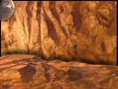
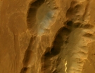
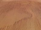
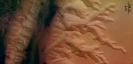
| Location: 285° E, 5° S - Candor Chasma Image Resolution: app. 40 m per pixel View: Overhead Description: Traces of erosion can be observed at the canyon walls, which are similar to erosion features observed on Earth in arid or alpine regions. |
|
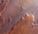
08 December 2004
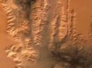
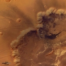
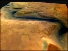
| Location: 102° E, 42° S - Reull Vallis Image Resolution: app. 21 m per pixel View: Overhead Description: Reull Vallis is an outflow channel that extends 1500 kilometres across Promethei Terra in the direction of Hellas Basin. |
|
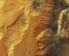
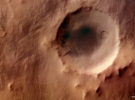
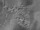
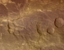
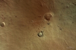
24 November 2004
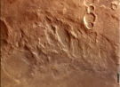
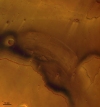
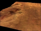
| Location: 324° E, 36° S - Hale Crater Image Resolution: app. 40 m per pixel View: Overhead Description: The region around the Hale crater is heavily eroded by deposits from the impact, and subsequent processes. |
|
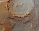
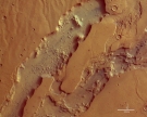
17 November 2004
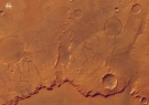
| Location: 301° E, 14° S - Coprates Catena Image Resolution: app. 43 m per pixel View: Overhead Description: Coprates Catena is a chain of collapsed structures, which run parallel to the main valley Coprates Chasma. |
|
11 November 2004
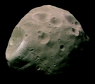
| Object: Phobos Image Resolution: app. 7 m per pixel View: From 200 kilometres Description: This image is one of the highest-resolution pictures so far of the Martian satellite Phobos. It shows the Mars facing side of the moon and was taken on 22 August 2004. |
|
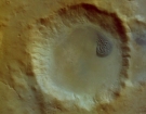
03 November 2004
| Location: 269° E, 7° S - Tithonium Chasma Image Resolution: app. 52 m per pixel View: Overhead Description: The image shows the western end of the canyons Tithonium Chasma and Ius Chasma, part of the Valles Marineris canyon system, which are up to 5.5 kilometres deep. |
|
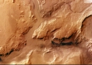
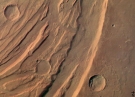
19 October 2004
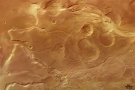
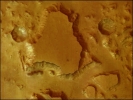
| Location: 61° E, 14° S - Huygens Crater Image Resolution: app. 70 m per pixel View: Overhead Description: This image shows part of the eastern rim of the Huygens crater which is heavily eroded. |
|
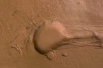
12 October 2004
| Location: 118° E, 42° S - Promethei Terra Image Resolution: app. 14 m per pixel View: Overhead Description: Area, east of the Hellas Planitia impact basin, with a smooth surface caused by a layer of dust or volcanic ash that is up to several tens of metres thick. |
|
30 August 2004
|
Location: 322° E, 11° S - Eos Chasma |
|
23 August 2004
|
Location: 303° E, 43° S - Argyre Planitia crater basin |
|
16 August 2004
| Location: 93° E, 32° S - Dao Valles and Niger Valles Image Resolution: 40 m per pixel View: Overhead Description: This image shows the Dao Valles and Niger Valles areas at a point where the north-eastern Hellas impact crater basin and the Hesperia Planum volcanic region meet. |
|
23 July 2004
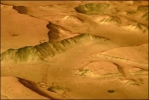
| Location: 220° E, 6° N - south of Olympus Mons Image Resolution: 20 m per pixel View: Perspective Description: In this region near Olympus Mons the surface shows a structure of 'yardang' features, which was probably sculpted by wind-blown sand. |
|
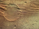
08 July 2004
Location: 68° E, 29° S - Hellas basin
Image Resolution: 18.3 m per pixel
View: Overhead
Description: Northern rim of the Hellas basin, a giant impact crater with a diameter of about 2300 kilometres.
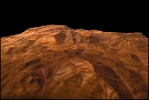
22 June 2004
| Location: 285° E, 12° S - Melas Chasma Image Resolution: app. 16 m per pixel View: Overhead Description: The image shows the southern rim of the Melas Chasma in the Valles Marinaris Canyon. It holds several clues to the morphological and geological development of the Valles Marineris. |
|
09 June 2004
|
Location: 209° E, 5° S - Mangala Valles |
|
24 May 2004
| Location: 239°E, 10°S - Arsia Mons Image Resolution: 20 m per pixel View: Overhead from app. 400 km Description: This image shows a zone of collapse features on the southern flank of the giant shield volcano Arsia Mons. Some of the collapse pits are 2 km deep. |
|
07 May 2004
| Location: 220°-230° E, 35°-40° N - Acheron Fossae Image Resolution: 30 m per pixel View: Overhead from 765 km Description: A system of parallel running fault lines in the Acheron Fossae region indicates the geological active past. |
|
| Location: 220°-230° E, 35°-40° N - Acheron Fossae Image Resolution: 30 m per pixel and 50 m per pixel View: Overhead from 765 km and 1240 km Description: A system of fault lines is seen running through a 55-kilometre diameter impact crater. |
|
21 April 2004
| Location: 222° E, 22° N - Olympus Mons western flank Image Resolution: app. 25 m per pixel View: Overhead Description: The escarpment at lower left rises from the surface level to over 7000 metres. At the top of the image, part of the extensive plains west of the escarpment are shown, known as the 'aureole'. |
|
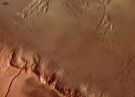
08 April 2004
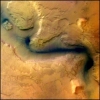
| Location: 278.8° E, 8.3° S - Louros Valles Image Resolution: 13.0 m per pixel View: Overhead from 269 km Description: The image shows a system sapping of channels south of the Ius Chasma canyon which runs west to east. |
|
31 March 2004
| Location: 255.7° E, 30.9° N - Claritas Fossae Image Resolution: 17.0 m per pixel View: Overhead from 271 km Description: Claritus Fossae is an ancient tectonic region west of Solis Planum and south-east of the Tharsis volcano chain. |
|
22 March 2004
| Location: 255.5° E, 7.9° N - Ascraeus Mons Image Resolution: 16.8 m per pixel View: Overhead from 271 km Description: The southern flank of Ascraeus Mons, the northernmost of the three Tharsis Volcano Group. The image reveals many features associated with lava channels and collapsed lava tunnels. |
|
01 March 2004
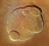
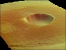
| Location: 150° E, 31.7° N - Hecates Tholus Image Resolution: 12.5 m per pixel View: Overhead from 275 km Description: Hecates Tholus is the nothernmost volcano of the Elysium group. The volcano stands 5.2 km high with a caldera 10 km wide and up to 600 m deep. |
|
18 February 2004
| Location: 309° E, 29.8° N - Kasei Vallis Image Resolution: 12 m per pixel Area Covered: 130 km wide View: Overhead Description: Kasaei Vallis is the largest outflow channel on Mars. It was possibly created by glacial erosion or water outflows from subglacial lakes. |
|
11 February 2004
| Location: 227° E, 18.3° N - Olympus Mons Image Resolution: 12 m per pixel View: Overhead Description: The largest volcano in the Solar System standing 24 km above the surrouding plateau. The caldera is estimated to be 3 km deep. |
|
10 February 2004
| Location: 323° E, 1° S to 2.5° N - Mars Equatorial region Image Resolution: 12 m per pixel Area Covered: 50 km top to bottom View: Overhead Description: The features in the picture indicate erosional processes possibly caused by water. |
|
| Location: 323° E, 5 to 10° N - region north of Valles Marineris Image Resolution: 12 m per pixel Area Covered: 50 km top to bottom View: Overhead Description: The features in the picture indicate erosional processes possibly caused by water. |
|


23 January 2004
Location: Albor Tholus
Description: The image reveals dust, blown by a surface winds, falling over the edge of the summit caldera of Albor Tholus, a volcano in the Elysium region. The caldera is 30 km in diameter and has a depth of 3 km. The volcano as a whole has a diameter of 160 km and a height of 4.5 km.
Location: 323° E, 15° S - region south of Valles Marineris
Image Resolution: 12 m per pixel
Area Covered: 50 km across
View: Overhead
Description: Tectonically controlled karst-like structure.
Location: 323° E, 15° S - region south of Valles Marineris
Image Resolution: 12 m per pixel
Area Covered: 50 km across
View: Perspective
Description: Tectonically controlled karst-like structure.
View: Overhead
Description: A mesa in the true colours of Mars. The summit plateau stands about 3 km above the surrounding terrain. The original surface was dissected by erosion, only isolated mesas remained intact. The large crater has a diameter of 7.6 km.
View: Perspective
Description: A mesa in the true colours of Mars. The summit plateau stands about 3 km above the surrounding terrain. The original surface was dissected by erosion, only isolated mesas remained intact.
Location: 101° E, 41° S - region east of the Hellas Basin
Image Resolution: 12 m per pixel
Area Covered: 100 km across
View: Overhead
Description: A dried up river channel (Reull Vallis) possibly showing the remains of some sediement (the darker feature).
Location: 101° E, 41° S - region east of the Hellas Basin
Image Resolution: 12 m per pixel
Area Covered: 100 km across
View: Perspective
Description: A dried up river channel (Reull Vallis) possibly showing the remains of some sediement (the darker feature).
Location: 323° E, 5° N - Valles Marineris
Image Resolution: 12 m per pixel
Area Covered: 50 km across
View: Overhead
Description: An image showing mesas and cliffs as well as flow features which indicate erosion by the action of flowing water. The dark feature to the left of the image is, as yet, of undetermined composition.
Location: Gusev Crater Region
Area Covered: 3700 km from top to bottom and up to 166 km wide
View: Overhead
Description: A huge thin strip of the surface of Mars centred on the landing site for the NASA Spirit rover.

Location: Gusev Crater
Area Covered: 60 km
View: Overhead from 320 km
Description: The landing site for the NASA Spirit rover. (Note the green colour is an effect of image processing)
Location: Valles Marineris
Resolution: 12 km per pixel
View: Overhead
Description: A series of erosional features contained within the giant Valles Marineris canyon.
Location: Valles Marineris
Resolution: 12 km per pixel
View: Perspective
Description: A series of erosional features contained within the giant Valles Marineris canyon.
Location: Valles Marineris
Area Covered: 60 km
View: Montage
Description: A series of erosional features contained within the giant Valles Marineris canyon.