Impact Schedule: 01 September 2006
1 September 2006
Revised impact predictions have been generated based on the SMART-1 orbit determination from 1 September 2006.The calculations include a scheduled manoeuvre in the night of 1/2 September to raise the perilune by 600 m in order to maximise the chance to impact at the nominal perilune.
 |
|
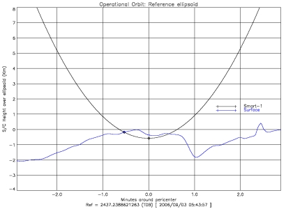
Projected Impact Trajectory and Lunar Topography |
The longitude and latitude are planetographic and expressed w.r.t. to the IAU 1991 moon fixed system.
The height is relative to the DEM model derived from the Clementine LIDAR data.
| Perilune Passage: Nominal Impact Orbit -2 | |
| Time: | 2006/09/02 19:32:56.631 (UTC) |
| Longitude | 319.26963343790° |
| Latitude | -36.48068123967° |
| Height (topograph) | 3336.417 (m) |
| Position vector in Mean Equatorial 2000, Earth centred: | |
| X-Axis Component | 18506.4917583 (km) (MEQ2T) |
| Y-Axis Component | -330645.8322386 (km) (MEQ2T) |
| Z-Axis Component | -182194.4186395 (km) (MEQ2T) |
| Perilune Passage: Nominal Impact Orbit -1 | |
| Time: | 2006/09/03 00:37:54.709 (UTC) |
| Longitude | 316.50051484751° |
| Latitude | -36.46925842646° |
| Height (topograph) | 2056.054 (m) |
| Position vector in Mean Equatorial 2000, Earth centred: | |
| X-Axis Component | 37278.7966615 (km) (MEQ2T) |
| Y-Axis Component | -328360.7706147 (km) (MEQ2T) |
| Z-Axis Component | -180782.7010628 (km) (MEQ2T) |
| Nominal Impact Location | |
| Time: | 2006/09/03 05:42:20.320 (UTC) |
| Longitude | 313.80504815341° |
| Latitude | -34.26931947746° |
| Height (topograph) | 0.000 (m) |
| Position vector in Mean Equatorial 2000, Earth centred: | |
| X-Axis Component | 55950.0563311 (km) (MEQ2T) |
| Y-Axis Component | -325240.8796856 (km) (MEQ2T) |
| Z-Axis Component | -178858.5549383 (km) (MEQ2T) |
| Perilune Passage: Nominal Impact Orbit | |
| Time: | 2006/09/03 05:42:52.504 (UTC) |
| Longitude | 313.73194150408° |
| Latitude | -36.45157493490° |
| Height (topograph) | -215.199 (m) |
| Position vector in Mean Equatorial 2000, Earth centred: | |
| X-Axis Component | 55964.5352942 (km) (MEQ2T) |
| Y-Axis Component | -325246.2787471 (km) (MEQ2T) |
| Z-Axis Component | -178917.4134305 (km) (MEQ2T) |
| Perilune Passage: Nominal Impact Orbit +1 | |
| Time: | 2006/09/03 10:47:49.998 (UTC) |
| Longitude | 310.96356203210° |
| Latitude | -36.42740130684° |
| Height (topograph) | -2149.739 (m) |
| Position vector in Mean Equatorial 2000, Earth centred: | |
| X-Axis Component | 74515.7058281 (km) (MEQ2T) |
| Y-Axis Component | -321301.7515481 (km) (MEQ2T) |
| Z-Axis Component | -176598.6075025 (km) (MEQ2T) |
| Perilune Passage: Nominal Impact Orbit +2 | |
| Time: | 2006/09/03 15:52:47.171 (UTC) |
| Longitude | 308.19531851654° |
| Latitude | -36.39619940332° |
| Height (topograph) | -3292.450 (m) |
| Position vector in Mean Equatorial 2000, Earth centred: | |
| X-Axis Component | 92883.6287530 (km) (MEQ2T) |
| Y-Axis Component | -316528.7971719 (km) (MEQ2T) |
| Z-Axis Component | -173827.5476146 (km) (MEQ2T) |
Last Update: 1 September 2019
