AMIE View of SMART-1 Impact Site
Date: 19 August 2006
Satellite: SMART-1
Depicts: AMIE view of nominal impact site
Copyright: ESA/SPACE-X & Clementine Project, BMDO, NRL, LLNL
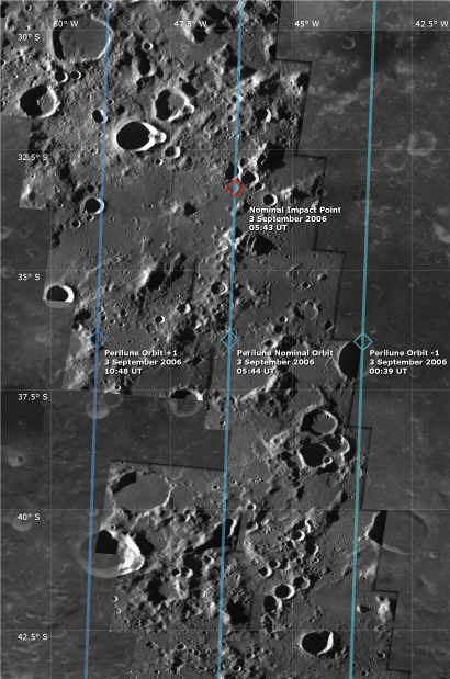
This map shows a mosaic of AMIE images covering the area around the SMART-1 impact site, on top of a Clementine map of the lunar surface in cylindrical projection. AMIE obtained the images on 19 August 2006, some two weeks before the nominal impact date. North is up.
Running across this view are three ground traces, one of the SMART-1 nominal impact orbit (central blue line) and one for each orbit on either side of the nominal impact orbit. The three successive perilune points are indicated by the blue diamonds.
SMART-1 will pass from north to south over the area and is expected to impact with the lunar surface on 3 September 2006, at 05:43 UT, one minute before perilune of the impact orbit. The nominal impact point is marked by the red diamond.
| Parameter | Value |
| Date | 19 August 2006 |
| Longitude | 41.7° - 51.0° W |
| Latitude | 29.5° - 43.5° S |
