Transition Region North of Hellas Basin
Date: 17 December 2006
Satellite: Mars Express
Depicts: HRSC image of area directly north of Hellas Basin
Copyright: ESA/DLR/FU Berlin, CC BY-SA IGO 3.0
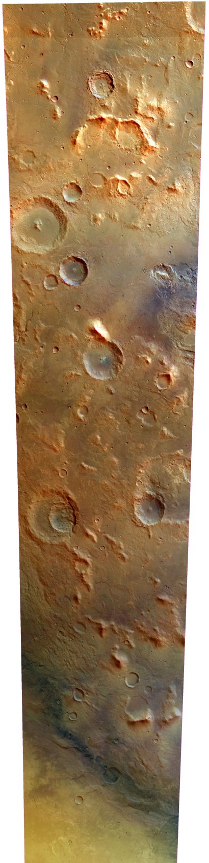
This image was obtained by the High-Resolution Stereo Camera (HRSC) during Mars Express' 411th orbit. The view shows a strip across the transition region between the extensive land mass Tyrrhena Terra, in the upper half of the image, and the large Hellas impact basin. The northern edge of the Hellas basin can be seen running diagonally across the image in the lower half of the image.
With a diameter of ~2100 km, Hellas is the largest impact crater on Mars. In the Martian southern winter, the basin is often filled with white CO2 frost, making it stand out even more from the surrounding terrain.
The large area of Tyrrhena Terra is part of the ancient cratered southern highlands on Mars. The terrain is composed of material that is a mixture of ejecta from the Hellas impact, pre-basin remnants, and highland terrain. Subsequent impacts have scarred the area with numerous smaller craters. The region has been weathered further by fluvial and lake deposits, erosion, tectonic movements, volcanic materials and aeolian (wind) processes.
At the top left border of the image is crater Rungana. This is a small crater with a diameter of ~40 km and a central uplift. It is located at 75.9° E, 26.3° S and is named after a town in New Zealand. Directly south-east of crater Rungana, lies the small crater Jörn with a diameter of ~20.7 km. It is located at 76.3° E, 26.9° S and is named after a town in Sweden.
Image created by ESA Science from data contained in the Mars Express public archive. The selected colour scheme is an interpretation based on the original raw data.
An anaglyph of this image is available under the related images in the right-hand side navigation.
*Note: some of the image versions provided are very large (2973 x 12283 pixels) and may take some time to open.
| Image Details | |||||||||
| Orbit Number |
411 |
||||||||
| Image capture start | 2004-05-17 T 20:07:09.178 | ||||||||
| Image capture stop | 2004-05-17 T 20:12:57.497 | ||||||||
| Borders |
|
||||||||
| Source reference files |
|
||||||||
| Max. resolution of original |
|
||||||||
| Max. resolution of processed file |
19.5 m per pixel |
||||||||
This work is licensed under a Creative Commons Attribution-ShareAlike 3.0 IGO License. 
