Background Science
There are spectacular mountains three times as tall as Mount Everest, canyons three times as deep and five times as long as the Grand Canyon, vast ice fields and thousands of kilometres of features that are reminiscent of dry river beds on Earth.
Table of Martian Facts
| Orbit: |
227 940 000 km (1.52 AU) mean distance from Sun |
| Diameter: | 6794 km |
|
Martian day: |
24 hours, 37 minutes and 22 seconds |
| Martian year: | 669 Martian days 687 Earth days |
|
Average temperature: |
218 K (-55oC) |
|
Minimum temperature: |
140 K (-133oC) (at the winter pole) |
|
Maximum temperature: |
300 K (27oC) (summer dayside) |
|
Surface area: |
about the same as the land surface area of Earth |
|
Highest mountain: |
Olympus Mons - the largest mountain in the Solar System rising 24 km above the surrounding plain. Its base is more than 500 km in diameter and is rimmed by a cliff 6 km high |
|
Largest canyon: |
Valles Marineris - a system of canyons 4000 km long and from 2 km to 7 km deep, and up to 20 km wide. |
|
Largest impact crater: |
Hellas Planitia - an impact crater in the southern hemisphere over 6 km deep and 2000 km in diameter |
|
Surface bulge: |
Tharsis - a huge bulge on the Martian surface that is about 4000 km across and 10 km high |
Mars is a smallish planet - its radius is just a little over half the Earth's. Yet it boasts scenery on a scale that makes Mount Everest and the Grand Canyon seem puny by comparison.
 |
|
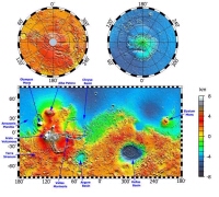
Topography map of Mars compiled by NASA's Mars Global Surveyor |
Then there is the Hellas Basin in the southern hemisphere, which is a massive impact crater 2300 km in diameter and more than 9 km from top to bottom. The bottom of the Hellas Basin has the lowest elevation on the planet. But perhaps most striking of all is the general difference in height and surface roughness between the northern and southern hemispheres. A quick glance at the map above shows a southern hemisphere pock marked with craters and with generally much higher terrain than the relatively smooth northern hemisphere.
This map was compiled in summer 1999 from data recorded by the Mars Orbiter Laser Altimeter (MOLA) on board NASA's Mars Global Surveyor (MGS) spacecraft. MOLA is measuring the height of the Martian surface to within 13 metres of elevation on average; the heights of some parts of the Earth aren't known so accurately. It has revealed for the first time that the slope from south to north is gradual and that the average elevation in the south is 6 km higher than in the north.
 |
|
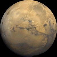
Image of Mars taken from NASA's Viking spacecraft showing the Valles Marineris canyon in the middle of the image and the Tharsis volcanoes on the western edge of the planet |
Such questions may seem highly specialised, of interest only to planetary geologists. But the answers will shed light on the really big questions about Mars, such as the fate of the water that almost certainly existed on the planet in its early history; whether Martian life exists, has ever existed, or could have existed at some time in the past; and even whether Mars could make a hospitable venue for human exploration.
MOLA is not the only instrument on MGS to be returning exciting new data. The camera is taking sharper shots of surface features than ever before, revealing for the first time layers in the rock and soil over much of Mars. Also caught on camera are dust storms and dust devils which give clues about the Martian weather and processes in the atmosphere.
MGS and Mars Odyssey are returning significant data about Mars and were recently joined by the Mars Express orbiter that arrived 25 December 2003. They will be joined by more spacecraft in the future as an unprecedented number of space vehicles are due for launch to Mars before 2010 under the auspices of an international effort to explore the red planet. Each will expand and add new dimensions to our knowledge.
