HRSC Topographic Maps of Mars
13 February 2007
Data obtained with the High-Resolution Stereo Camera (HRSC) has been used to produce new topographic maps of Mars at different scales.
 |
|
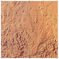
Topographic map at 1:200 000 |
In these maps, contour lines indicating the height of the landscape are superimposed upon HRSC high-resolution images of the Iani Chaos region. The height information is taken from Digital Terrain Models of the Martian surface, which are also created from HRSC data.
The new maps have been produced under the leadership of the Principal Investigator (PI) G. Neukum (Freie Universität Berlin), as part of the effort of the science and experiment team of the HRSC experiment, by J. Albertz and S. Gehrke of the Institute for Geodesy and Geoinformation Science, Technische Universität Berlin, in cooperation with the German Aerospace Centre (DLR), Institute of Planetary Research, Berlin.
All maps and details can be found through the link on the right-hand side.