Ten years at Mars: new global views plot the Red Planet's history
3 June 2013
New global maps of Mars released on the 10th anniversary of the launch of ESA's Mars Express trace the history of water and volcanic activity on the Red Planet, and identify sites of special interest for the next generation of Mars explorers.The unique atlas comprises a series of maps showing the distribution of minerals formed in water, by volcanic activity, and by weathering to create the dust that makes Mars red. They create a global context for the dominant geological processes that sculpted the planet we see today.
The maps were built from ten years of data collected by the OMEGA mineralogical mapper on Mars Express, which determines the mineral composition of the martian surface by analysing the spectrum of reflected sunlight.
| Mars mineral maps. Credit: ESA (Click here for further details and larger versions of this video.) |
"The history of Mars is encoded in its minerals," says Alvaro Giménez, ESA’s Director of Science and Robotic Exploration. "These new global views, made possible thanks to the longevity of ESA’s Mars Express mission, are helping us to unlock the secrets of 4.6 billion years of planetary evolution.
"The atlas released today will help to determine future landing sites for the next generation of Mars landers and rovers, and identify sites of special interest for future manned missions, helping to keep Europe at the forefront of planetary exploration."
Each map represents a different chapter in the story of geological evolution on Mars.
Maps showing the distribution of minerals formed in water
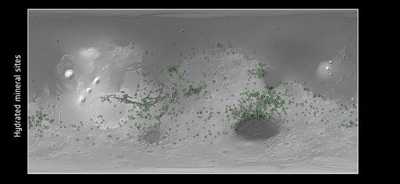 |
| Map showing distribution of hydrated minerals. Credit: ESA/CNES/CNRS/IAS/Université Paris-Sud, Orsay; NASA/JPL/JHUAPL; Background image: NASA MOLA |
The first map shows individual sites of hydrated minerals – 'phyllosilicates' and hydrated salts that form only in the presence of water. These are primarily seen in the most ancient cratered terrain dating back to over four billion years ago, suggesting that Mars sustained surface and subsurface liquid water during its first few hundred million years, potentially providing conditions favourable to early life.
Maps showing the distribution of minerals formed by volcanic activity
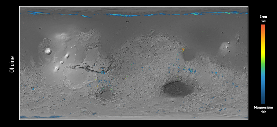
The next two maps showing the minerals olivine and pyroxene tell the story of volcanism, with differences in the chemical composition of the solidified lavas yielding clues as to the evolution of the temperature and pressure inside the planet.
 |
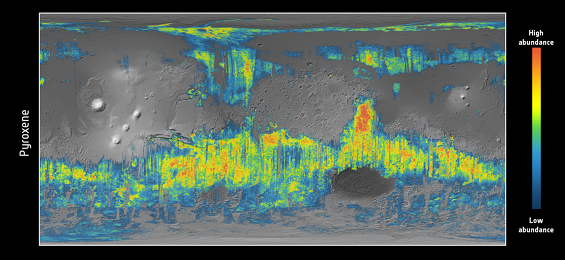 |
| Map showing distribution of olivine (top) and pyroxene (bottom). Credits: ESA/CNES/CNRS/IAS/Université Paris-Sud, Orsay; Background image: NASA MOLA |
Olivine and pyroxene are the two primary minerals in basalt that form when lava solidifies. Basalt characterises the crust of Mars as well as oceanic crust on Earth and the volcanic seas on the Moon.
Some of the most pristine, magnesium-rich olivines exposed on the surface of Mars today are found around impact craters that have excavated samples of very ancient mantle from beneath the crust.
Olivine-rich surfaces are also associated with a global lava-flooding event around 3.7 billion years ago, when magma erupted onto the surface through fractures in the floors of impact craters, similar to the way in which the Moon's large impact basins were flooded with volcanic lava. Only a few traces of this global event remain today, with subsequent geological activity overprinting the signature.
Pyroxenes are particularly widespread in the cratered highlands, pointing to some of the most ancient portions of the planet’s crust. In the smooth northern plains, the pyroxenes reflect the eruption of more evolved lavas compared to the pristine olivines.
Maps showing the distribution of dust created by weathering
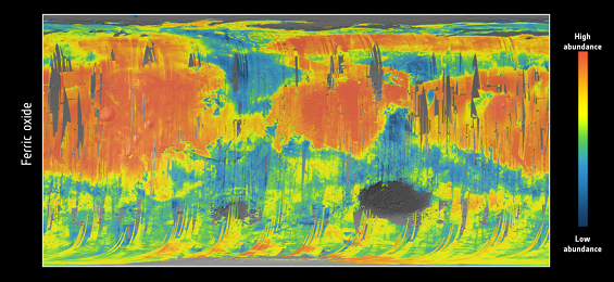
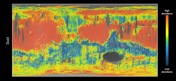
Dust obscures much of the underlying rock on Mars, but it is very closely related to ferric oxide, a mineral phase of iron found all over the planet, with greatest abundances in the northern lowlands and the volcanic province of Tharsis.
The Red Planet's dust is thought primarily to result from chemical reactions with the atmosphere, causing the iron-rich rocks to 'rust' slowly over billions of years, giving Mars its distinctive hue.
Weathering and erosion from past glacial activity and impact events, as well as dust storms, winds and freezing and thawing cycles today, contribute to the continued production of fine-grained dust.
"Collectively, these mineral maps provide unique records of the planet's evolution through time. They exhibit the role water and volcanic processes played over the entire planet, spanning geological aeons," says Jean-Pierre Bibring, Principal Investigator for OMEGA.
Maps providing hints for future in-situ exploration
The maps also highlight areas of particular scientific interest that may warrant further in-situ exploration, such as the abundance of hydrated mineral exposures clustered along the boundary between the low northern plains and the ancient cratered highlands.
"Against the flanks of these cliffs, thick ice deposits may have preserved ancient water-altered sites for a longer period of time than in more exposed locations," says Professor Bibring.
In some places, the maps show an overlap between volcanic outcrops and hydrated minerals: here, minerals may have become altered via heating during volcano–ice interactions.
One such location, known as Nili Fossae, is identifiable by the obvious bright red/yellow spot in the olivine map, a mineral easily weathered into clay in the presence of water. If rocks here were altered by hydrothermal activity, then conditions may have once existed there to support life.
"These are very special sites – possibly unique within the entire Solar System – with well preserved records of the environment during the few hundreds of millions of years following planet formation, during which life might have emerged on Earth and possibly at Mars," adds Professor Bibring.
Ten years of discovery
In addition to the tantalising tale of the history of water and volcanism on the surface, Mars Express has also been conducting a wide range of studies of the Red Planet, from the subsurface all the way up to the upper atmosphere and beyond to Mars’ two tiny moons, Phobos and Deimos, providing an
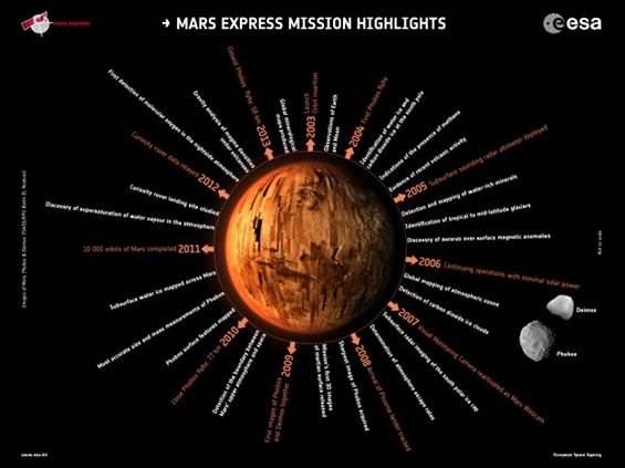 |
| Poster showing some of the scientific and operational highlights from Mars Express, 2003-2013. Credits: Images of Mars, Phobos & Deimos: ESA/DLR/FU Berlin (G. Neukum) |
Over 95% of the surface has been imaged by the mission's high-resolution camera, with two thirds mapped at a resolution of 20 m per pixel or better, and much of it in stereo, yielding stunning 3D images.
Ground-penetrating radar has added a third dimension to the planet by determining the vertical extent of the polar ice caps. At the south pole, there is enough water locked up in ice to cover the entire planet with a layer of water 11 m deep if melted.
Meanwhile the detection of traces of methane in the atmosphere has led to an intense debate in the scientific community: does it have a volcanic origin, or could it be the result of active biology, as it is on Earth?
Mars Express has also provided the most detailed atlas of its innermost moon Phobos, and in December this year will make its closest pass yet, just 58 km from the centre of the tiny moon.
"The decade-long observations by Mars Express of all aspects of the martian environment are providing us with a truly global perspective on the history of the Red Planet, paving the way for the next generation of Mars exploration missions," says Olivier Witasse, ESA's Mars Express Project Scientist.
"But we still have a lot to look forward to and are planning a number of unique observations with Mars Express, such as coordinating measurements of the atmosphere with NASA's MAVEN spacecraft, watching the very close pass of Comet C/2013 Siding Spring by Mars in October 2014, and monitoring the arrival of ESA's ExoMars Entry, Descent, and Landing Demonstrator module in October 2016."
Notes for Editors
Related papers:
“Global maps of anhydrous minerals at the surface of Mars from OMEGA/MEx,” by A. Ody et al., is published in the Journal of Geophysical Research 117, (2012).
“Global investigation of olivine on Mars: Insights into crust and mantle compositions,” by A. Ody et al., is published in the Journal of Geophysical Research, 118 (2013).
“Hydrous minerals on Mars as seen by the CRISM and OMEGA imaging spectrometers: Updated global view,” by J. Carter et al., is published in the Journal of Geophysical Research 118 (2013).
OMEGA observations
The new maps are based primarily on data collected by the visible and infrared mineralogical mapping spectrometer, OMEGA (Observatoire pour la Minéralogie, l’Eau, les Glaces et l’Activité). It determines mineral composition from the visible and infrared light reflected from the planet's surface in the wavelength range 0.5–5.2 microns. As light reflected from the surface must pass through the atmosphere before entering the instrument, OMEGA also measures aspects of atmospheric composition. However, the atmosphere is so dense over the 9 km-deep Hellas Basin that detections from the crater floor cannot be made by OMEGA, resulting in the data gap seen on the maps. The vast distance between the surface to Mars Express also impairs measurements over the smaller Argyre basin just to the left of centre in the southern hemisphere.
Seasonal carbon dioxide and water ice frosts occurring in the polar regions restricts observing periods and spatial coverage in these regions.
OMEGA maps the surface composition in 100 m squares. It samples the surface from 4.1 km/pixel down to 350 m/pixel, nadir-pointed. It has achieved 51% coverage at samplings < 500 m/pixel and near total coverage at samplings < 4.1 km/pixel.
The map showing hydrated minerals includes detections made by both ESA’s Mars Express and by NASA’s Mars Reconnaissance Orbiter.
About Mars Express
Mars Express was launched on 2 June 2003 on a Soyuz/Fregat from Baikonur, Kazakhstan. It carries seven scientific instruments: ASPERA (energetic neutral atoms analyser); HRSC (High Resolution Stereo Camera); MaRS (Mars radio sciece experiment); MARSIS (subsurface sounding radar altimeter); OMEGA (visible and infrared mineralogical mapping spectrometer); PFS (Planetary Fourier Spectrometer); and SPICAM (ultraviolet and infrared atmospheric spectrometer). It also transported the Beagle-2 lander to Mars, but contact was lost during landing.
For further information, please contact:
Markus Bauer
ESA Science and Robotic Exploration Communication Officer
Tel: +31 71 565 6799
Mob: +31 61 594 3 954
Email: markus.bauer![]() esa.int
esa.int
Olivier Witasse
Mars Express Project Scientist
Tel: +31 71 565 8015
Email: Olivier.witasse![]() esa.int
esa.int
Jean-Pierre Bibring
OMEGA Principal Investigator
Institut d’Astrophysique Spatiale, Université Paris 11 Orsay
Tel: +33 1 69 85 86 86
Email: jean-pierre.bibring![]() ias.u-psud.fr
ias.u-psud.fr
ESA Media Relations Office
Tel: +33 1 53 69 72 99
Email: media![]() esa.int
esa.int
(This article was originally published on ESA's Space Science Portal.)

