Fourth Close Titan Flyby
30 March 2005
Titan-4 is the fifth targeted encounter of Saturn's largest moon, and the fourth close flyby. The flyby occurs on Thursday 31 March at 20:05 UT. The closest approach will be at an altitude of 2402 km above the surface at a speed of 5.9 kms-1. Titan has a diameter of 5150 km, so the spacecraft passes within just two Titan radii.The encounter is set up with two approach manoeuvres: an apoapsis manoeuvre (OTM #18) on 19 March and another Titan targeting manoeuvre (OTM #19) on 27 March, four days before the encounter.
This Titan flyby encounter will be the first outbound flyby of Cassini's Tour, with Saturn periapsis occurring almost two days earlier. The observations will be done using reaction wheels for attitude control. The local time at the closest approach will be near dawn.
Science Activities
There will be 3716 Mbits received on Earth over a 9-hour period, starting Friday 1 April at 16:35 UT. These will contain the results of the science activities as summarized below:
- UVIS EUV & FUV observations to map airglow emission lines from nitrogen and carbon and measure reflected sunlight from Titan's haze which carries information about particle size and properties.
- RADAR radiometry complementary coverage to Ta.
- VIMS evolution of clouds and other transient features on Titan. High resolution compositional mapping of the northern hemisphere.
- RPWS to determine thermal plasma parameters (electron temperature and density), investigate the interaction between the magnetosphere and Titan's ionosphere, search for lightning on Titan, and look for new phenomena, such as radio emissions from the Titan-magnetosphere interaction.
- Detailed study of Titan's interaction with Saturn's magnetosphere, as well as further constrain the possible internal magnetic field of Titan. Characterize the ion composition and charge state near Titan.
- CIRS observations of Titan's atmosphere, in particular the northern hemisphere, measuring vertical profiles of temperature, looking for aerosols, and measuring distribution of CO, HCN, and CH4.
Table of Events
27 February 2005
| Time UTC | Time wrt Titan-4 |
Event |
| 00:36:00 | - 32d 19h | Start of Sequence S09 that contains Titan-4 |
27 March 2005
| Time UTC | Time wrt Titan-4 |
Event |
| 20:00:00 | - 04d 00h | OTM #19 Prime Titan-4 minus 3 day targeting manoeuvre |
28 March 2005
| Time UTC | Time wrt Titan-4 |
Event |
| 19:17:00 | - 03d 01h | OTM #19 Backup |
31 March 2005
| Time UTC | Time wrt Titan-4 |
Event |
| 05:50:00 | - 14h 15m | Start of the TOST Segment |
| 05:50:00 | - 14h 15m | Turn cameras to Titan |
| 06:20:00 | - 13h 45m | Deadtime 75 minutes long; used to accommodate changes in flyby time |
| 07:35:16 | - 12h 30m | Far Infrared, long integration nadir composition observation to obtain information on CO, HCN, CH4, etc. |
| 11:35:16 | - 08h 30m | Medium resolution imaging combined with wide angle camera photometery. Design specifically worked in coordination with Infrared Imager (VIMS) for overall coverage |
| 14:35:16 | - 05h 30m | RADAR Radiometry + scatterometry |
| 19:35:16 | - 00h 30m | High Resolution Imaging; specifically targeting the surface covered in T3 closest approach RADAR SAR |
| 20:05:16 | + 00h 00m | Titan-4 Flyby Closest Approach Time. Altitude = 2402 km, speed = 5.9 kms-1; moderate phase inbound (~58°), 65° phase at closest approach, high phase outbound (~124°) |
| 20:05:16 | + 00h 00m | Slow scans across Titan's atmosphere at the limb. Measuring vertical profiles of temperature in Titan's atmosphere |
| 20:50:16 | + 00h 45m | Slow scans across Titan's atmosphere at the limb. Looking for aerosols |
| 21:20:16 | + 01h 15m | Far Infrared, limb integration at two locations. Measuring vertical distribution of CO, HCN, CH4 |
| 22:05:16 | + 02h 00m | Several slow scans across Titan's visible hemisphere to form spectral images |
1 April 2005
| Time UTC | Time wrt Titan-4 |
Event |
| 00:35:16 | + 04h 30m | Slow radial scans across Titan's atmosphere. Looking for vertical temperature in Titan's atmosphere |
| 04:05:16 | + 08h 00m | Far Infrared, long integration nadir composition observation to obtain information on CO, HCN, CH4, etc. |
| 08:05:16 | + 12h 00m | Multiple slews across Titan. Looking for information on thermal structure of Titan's stratosphere |
| 14:35:16 | + 18h 30m | Deadtime 18 minutes long; used to accommodate changes in flyby time |
| 14:53:00 | + 18h 48m | Turn to Earth-Line |
| 15:22:00 | + 19h 17m | Begin Playback of T4 Data, Madrid 70m |
2 April 2005
| Time UTC | Time wrt Titan-4 |
Event |
| 00:22:00 | + 01d 04h | End Playback of T4 Data |
Times last updated on 9 March 2005 - Subject to change.
The time is in UT of the event. After this it takes about 1 hour and 8 minutes for the signal to reach Earth.
Titan Surface Coverage
This map of Titan's surface illustrates the regions that will be imaged by Cassini during the spacecraft's close flyby of the haze-covered moon on 31 March 2005. At closest approach, the spacecraft is expected to pass approximately 2400 kilometres above the moon's surface.
|
|
|
Credit: NASA/JPL/Space Science Institute |
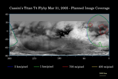
The coloured lines delineate the regions that will be imaged at different resolutions. Images from this encounter will include the eastern portion of territory observed by Cassini's radar instrument in October 2004 and February 2005. This will be the Cassini cameras' best view to date of this area of Titan.
The higher resolution (red) box at the northwestern edge of the covered region targets the area observed by Cassini's synthetic aperture radar at the closest approach point of the February flyby. The Cassini visual and infrared mapping spectrometer experiment will also be targeting this area during the 31 March flyby, yielding coverage of the same part of Titan's surface by three different instruments.
The map shows only brightness variations on Titan's surface (the illumination is such that there are no shadows and no shading due to topographic variations). Previous observations indicate that, due to Titan's thick, hazy atmosphere, the sizes of surface features that can be resolved are a few to five times larger than the actual pixel scale labelled on the map.
The images for this global map were obtained using a narrow band filter centred at 938 nanometres in the near-infrared. At that wavelength, light can penetrate Titan's atmosphere to reach the surface and return through the atmosphere to be detected by the camera. The images have been processed to enhance surface details.
It is currently northern winter on Titan, so the moon's high northern latitudes are not illuminated, resulting in the lack of coverage north of 35 degrees north latitude.
Observation Results
Imaging Science Subsystem (ISS)
|
Date: 8 April 2005 Credit: NASA/JPL/Space Science Institute Image Notes: A detailed view of the relatively faint haze in Titan's upper atmosphere, obtained with the narrow angle camera at 338 nm (UV). |
 |
|
Date: 8 April 2005 Credit: NASA/JPL/Space Science Institute Image Notes: Saturn with dark shadows cast by its rings, is seen through Titan's upper atmosphere in this visible light image from the wide angle camera. |
 |
|
Date: 8 April 2005 Credit: NASA/JPL/Space Science Institute Image Notes: Mosaic of a large region east of Xanadu, centred on 21° W, 1° N. Underneath the narrow angle camera mosaic is a wide angle camera image. |
 |
|
Date: 8 April 2005 Credit: NASA/JPL/Space Science Institute Image Notes: Composite view of four images taken at 938 nm, enhanced to improve visibility of surface features and overall brightness variations. |
 |
