Dione Flyby - October 2005
10 October 2005
October of 2005 continues with the amazing string of close icy satellite encounters. As September included closest-ever encounters with Tethys and Hyperion, October contains the single targeted encounter with Dione. Dione is uniquely identified by its curious wispy terrain and was discovered in 1684 by Jean-Domnique Cassini.The closest approach to Dione occurs on Tuesday, 11 October at 17:52 UTC at an altitude of 500 km above the surface and at a speed of 9 kilometres per second. Dione is spherical in shape and has a diameter of 1120 km, making it the third-largest icy satellite (after Iapetus and Rhea).
This encounter is set up with two manoeuvres: an apoapsis manoeuvre scheduled for 1 October, and an approach manoeuvre, scheduled for 8 October. The encounter itself occurs very near periapsis to Saturn. The cleanup manoeuvre for the flyby contains a large deterministic component (targeting for future encounters) and occurs less than a day after the encounter.
Occurring on orbit 16, Dione will be the seventh close encounter with icy satellites, after Phoebe, Enceladus (orbit 3, non-targeted), Enceladus (orbit 4), Enceladus again (orbit 11), Tethys (orbit 15, non-targeted) and Hyperion (also orbit 15). It could be argued that the study of Iapetus on orbit C was intense enough even at 120 000 km to merit inclusion in this list, which would make this encounter the eighth.
Science Activities
The 11 October 2005 flyby of Dione represents the single close encounter to Dione during the Cassini mission, and will provide the best-ever views of this curious satellite. The flyby geometry is oriented such that Dione's wispy terrain is easily observable by the remote-sensing instruments on Cassini. The primary science investigations will be centred around the following questions:
- What is the compositional makeup of Dione, other than water ice?
- Did resurfacing occur early in Dione's history?
- What do the cracks and fractures tell us about the recent geologic history of Dione?
- How does Dione interact with Saturn's rings and magnetosphere?
- Cassini Plasma Spectrometer (CAPS)
CAPS will make measurements of the plasma environment around Dione to understand its effects, if any, on the surround Saturn magnetosphere. During this upstream flyby, CAPS will control the pointing of the spacecraft during the closest-approach period, in order to obtain the most diagnostic measurements possible, close to the surface. - Composite Infrared Spectrometer (CIRS)
CIRS will perform scans of the disk of Dione to measure daytime and nighttime temperatures. These measurements will constrain the bolometric albedo, the thermal inertial and volatile stability of the surface. In particular, given the relatively fresh fractures across one hemisphere of Dione, endogenic emission would be an exciting find. - Imaging Science Subsystem (ISS)
For ISS, this Dione flyby provides an opportunity to capture the best images of the cracked wispy terrain to get a better idea of the scale of the features and grain size variations that may be causing the dramatic brightness differences. Furthermore, high-resolution images of Dione will enable researchers to study other areas of the body that have not been well observed by Cassini or Voyager. ISS will perform a mosaic on the inbound leg (111 000 km) for regional mapping. Closer to the surface, ISS will obtain images in different filter of the anti-Saturnian hemisphere and will perform crescent imaging on the outbound leg. - Radio and Plasma Wave Science (RPWS)
RPWS will look for evidence of a plasma source at Dione. The RPWS data will be used to examine the plasma wave spectrum for evidence of magnetosphere-moon interactions. RPWS measurements will also be used to look for the signature of dust impacts. - Ultraviolet Imaging Spectrograph (UVIS)
UVIS will observe observed Dione to look for evidence of a tenuous atmosphere. UVIS will also map the surface to look for brightness variations at far-UV wavelengths, indicative of compositional variations and/or grain size variations. - Visible and Infrared Mapping Spectrometer (VIMS)
Measurements by VIMS will investigate surface composition. VIMS will identify minerals and other non-water ice species in the surface of Dione. VIMS measurements will also be used to understand grain size variations across the surface.
Table of Events
8 October 2005
| Time UTC | Time wrt Dione-1 |
Event |
| 03:30:00 | - 03d 14h | OTM #37 Prime; Dione-1 approach targeting manoeuvre |
| 12:30:00 | - 03d 05h | Start of Sequence S15 which contains Dione-1 |
9 October 2005
| Time UTC | Time wrt Dione-1 |
Event |
| 09:11:00 | - 02d 09h | OTM #37 Backup |
10 October 2005
| Time UTC | Time wrt Dione-1 |
Event |
| 18:27:00 | - 23h 25m | Start of the SOST Segment |
| 20:26:00 | - 21h 26m | Turn cameras to Dione |
| 20:27:00 | - 21h 25m | Saturn observation UVIS, EUV-FUV map |
| 23:00:00 | - 18h 52m | Inbound Dione ORS observations (distant), Images, compositional and temperature maps between 805 000 km and 265 000 km |
11 October 2005
| Time UTC | Time wrt Dione-1 |
Event |
| 10:28:00 | - 07h 24m | Deadtime 15 minutes long; used to accommodate changes in flyby time |
| 10:43:06 | - 07h 09m | Turn to Earth |
| 11:02:06 | - 06h 50m | Short 2 hr data downlink - Goldstone 34m; Radio Science Dione Mass determination |
| 13:04:02 | - 04h 48m | Turn to Telesto; Telesto is used as the waypoint during Dione flyby period |
| 13:22:02 | - 04h 30m | Turn to Dione and begin high-res ORS observations; compositional information and maps between 150 000 km and 3500 km |
| 17:44:02 | - 00h 08m | CAPS Dione measurements |
| 17:52:02 | + 00h 00m | Dione-1 Flyby Closest Approach Time; altitude = 500 km, speed = 9.1 kms-1, low phase inbound, 66.4° phase at closest approach, high phase outbound |
| 18:07:22 | + 00h 15m | Outbound Dione ORS crescent images and nightside temperature map between 12 000 km and 49 000 km |
| 19:22:02 | + 01h 30m | ORS Telesto observations; best Telesto opportunity in the tour: observations from as close as 9750 km |
| 20:22:02 | + 02h 30m | Turn HGA to Dione |
| 20:52:02 | + 03h 00m | RADAR scatterometry and radiometry of Dione |
| 20:36:02 | + 02h 44m | Deadtime 15 minutes long; used to accommodate changes in flyby time |
| 23:50:56 | + 05h 58m | Turn to Earth |
12 October 2005
| Time UTC | Time wrt Dione-1 |
Event |
| 00:00:56 | + 06h 08m | Begin playback of Dione data, 8.5 hr downlink Canberra + Madrid 34m; also Radio Science Dione Mass determination |
| 08:25:00 | + 14h 33m | Turn to safe spacecraft attitude; dust crossing - HGA to dust ram direction |
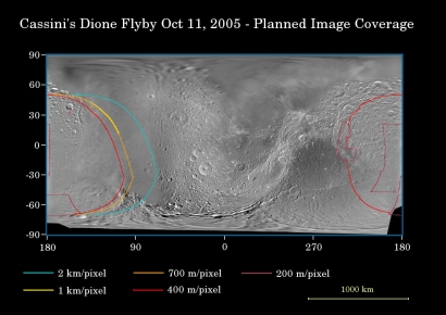
Dione Surface Coverage
 |
|
Image: NASA/JPL/Space Science Institute |
This map of the surface of Saturn's moon Dione illustrates the regions that will be imaged by Cassini during the spacecraft's very close flyby of the moon on 11 October 2005. At closest approach, the spacecraft is expected to pass approximately 500 kilometres above the moon's surface.
The coloured lines delineate the regions that will be imaged at differing resolutions, listed in the legend at the bottom.
Imaging scientists expect the Dione encounter to be one of the highlights of Cassini's mission. In terms of planning, this particular flyby is perhaps the most sophisticated yet undertaken by the Cassini imaging team. The timing of the imaging sequence has been optimised to within seconds, relative to the spacecraft's pointing during the encounter.
As Cassini approaches Dione, the cameras will capture regional-scale, medium resolution mosaics, with some coverage of the moon's relatively poorly imaged leading hemisphere (the region centred on 90° longitude). Planned inbound coverage also includes high-resolution images of the south pole and the well-known streaked terrain on Dione's trailing hemisphere. The previous flyby showed the markings to be an elaborate system of braided tectonic fractures.
During the outbound portion of the flyby, Cassini will image a crescent Dione as the moon recedes into the distance. While staring at the moon's dark side, Cassini will take images using long exposure times, in order to see terrain that is dimly illuminated by reflected light from Saturn. Such a technique was successfully employed during the New Year's Eve 2004 encounter with Iapetus.
This map was made from images obtained by both the Cassini and Voyager spacecraft.
Cassini previously flew past Dione at a distance of approximately 72 100 kilometres on 14 December 2004.
