Titan Flyby - 7 September 2006
7 September 2006
Nearly 47 days after Titan-16, Cassini returns to Titan for its eighteenth targeted encounter. The closest approach to Titan occurs on Saturday, 7 September, at 20:16 UT at an altitude of 1000 kilometers above the surface and at a speed of 6.0 kilometers per second. The latitude at closest approach is 23° N (near the equator), and the encounter occurs on orbit number 28.This encounter is set up with two manoeuvres: an apoapsis manoeuvre on 1 August, and an approach manoeuvre, on 4 September. This inbound encounter occurs about 2 days before Saturn closest approach.
Science Activities
- Visual and Infrared Mapping Spectrometer (VIMS)
A stellar occultation will allow to obtain a detailed profile of Titan's thermosphere - Composite Infrared Spectrometer (CIRS)
The CIRS observations emphasize the far-infrared part of the spectrum to map Titan's composition. CIRS will perform limb sounding with excellent vertical resolution. CIRS will also map surface temperatures - Imaging Science Subsystem (ISS)
The ISS outbound observations will image the surface of Titan and attempt to track atmospheric changes - Ion and Neutral Mass Spectrometer (INMS)
INMS is riding along near closest approach (secondary pointing is NEG_X to RAM). They will determine the atmospheric and ionospheric thermal structure as well as atmospheric density for the T17 latitude of 23° North. This is important for atmospheric modelling and will be used to plan for the T20 flyby (October 2006) - Magnetospheric and Plasma Science (MAPS)
MAPS will perform analysis of plasma wake, ions escaping from Titan, and Titan's interaction with Saturn's magnetosphere down to a low altitude (1000 km)
Table of Events
19 August 2006
| Time UTC | Time wrt Titan-17 |
Activity |
| 22:06:00 | -18d 22h | Start of Sequence S23 which contains Titan-17. |
4 September 2006
| Time UTC | Time wrt Titan-17 |
Activity |
| 12:21:00 | -03d 08h | OTM #70 Prime Titan-17 minus 3 day targeting manoeuvre |
5 September 2006
| Time UTC | Time wrt Titan-17 |
Activity |
| 12:06:00 | -02d 08h | OTM #70 Backup |
6 September 2006
| Time UTC | Time wrt Titan-17 |
Activity |
| 21:06:00 | -23h 10m | Start of the TOST Segment |
| 21:36:00 | -22h 40m | Turn cameras to Titan |
| 21:36:00 | -22h 40m | Deadtime, 20 minutes long; used to accommodate changes in flyby time |
| 21:56:51 | -22h 20m | Titan atmospheric observations to obtain information on the thermal structure of Titan's stratosphere |
7 September 2006
| Time UTC | Time wrt Titan-17 |
Activity |
| 05:16:51 | -15h 00m | Titan limb observations, search Titans nightside for atmospheric lightning and auras |
| 12:46:51 | -07h 30m | Titan surface observations, several slow scans across Titan's visible hemisphere to form spectral images |
| 17:31:51 | -02h 45m | Transition to thrusters, needed to compensate for Titan atmosphere torque and target motion compensation |
| 20:01:51 | -00h 15m | Titan stellar occultation |
| 20:08:51 | -00h 08m | Titan atmospheric observations, determine atmospheric and ionospheric thermal structure |
| 20:16:51 | +00h 00m | Titan-17 flyby closest approach time. Altitude = 1000 km, speed = 6.0 kms-1; high phase inbound, 45° phase at closest approach, low phase outbound |
| 20:35:59 | +00h 19m | Transition to reaction wheels. These are used for greater spacecraft stability |
| 20:57:08 | +00h 41m | Titan surface observations, several slow scans across Titan's visible hemisphere to form spectral images |
| 21:22:00 | +01h 06m | Descending ring plane crossing |
8 September 2006
| Time UTC | Time wrt Titan-17 |
Activity |
| 06:16:51 | +10h 00m | Titan surface observations, full disk observations for surface and atmospheric mapping |
| 09:54:51 | +13h 38m | Deadtime, 10 minutes long; used to accommodate changes in flyby time |
| 10:06:00 | +13h 50m | Turn to Earth-line |
| 10:36:00 | +14h 20m | Begin playback of T17 data Goldstone 70m |
| 21:06:00 | +01d 01h | End playback of T17 data |
9 September 2006
| Time UTC | Time wrt Titan-17 |
Activity |
| 17:42:00 | +01d 21h | Saturn periapse, R=3.0 Rs, latitude = -12°, phase = 7° |
Observation Results
Cassini Instrument: Cassini Radar (RADAR) and Visual and Infrared Mapping Spectrometer (VIMS)
|
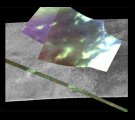
Date: 12 December 2006 Credit: NASA/JPL/University of Arizona Image Notes: This composite radar and VIMS view, holds the strongest indication yet of cryovolcanism on Titan: a possible flow of material out from a small crater |
 |
Cassini Instrument: Synthetic Aperture Radar (SAR)
|
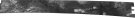
Date: 7 February 2007 Credit: NASA/JPL Image Notes: The entire strip obtained by the Cassini radar during this flyby, from which the below two scenes are taken. |
 |
|
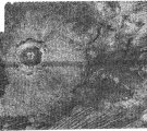
Date: 12 September 2006 Credit: NASA/JPL Image Notes: This image shows one of the few known impact craters on Titan. The crater has a diameter of ~30 km. Image is centred at 70° W, 10° N. |
 |
|
Date: 12 September 2006 Credit: NASA/JPL Image Notes: Dark long ridges are seen mostly in Titan's equatorial region and are thought to be longitudinal dunes. The image is centred at 44° W, 8° N. |
 |
