Titan Flyby - 23 September 2006
22 September 2006
Only 16 days after Titan-17, Cassini returns to Titan for its nineteenth targeted encounter. The closest approach to Titan occurs on Saturday, 23 September, at 18:59 UT at an altitude of 960 kilometres above the surface and at a speed of 5.8 kilometres per second. The latitude at closest approach is 71°, and the encounter occurs on orbit number 29.This encounter is set up with two manoeuvres: an apoapsis manoeuvre on 14 September and an approach manoeuvre, on 20 September. This inbound encounter occurs about 2 days before Saturn closest approach.
Science Activities
- Composite Infrared Spectrometer (CIRS)
CIRS will perform vertical sounding of stratospheric compounds on Titan, including H2O. CIRS will also obtain information on trace constituents - Ion and Neutral Mass Spectrometer (INMS)
INMS will determine atmospheric and ionospheric composition and thermal structure. INMS will see the transition from co-rotating to thermal particles, down through the ionospheric peak. They will measure neutrals inbound and neutrals and ions outbound. - Visual and Infrared Mapping Spectrometer (VIMS)
VIMS will perform nested mapping at high, medium and global resolution - Cassini Radar (RADAR)
RADAR will perform a high resolution SAR ride of Titan along with INMS - Radio and Plasma Wave Science (RPWS)
RPWS will perform thermal plasma density and temperature measurements with the Langmuir probe, search for lightning and other radio emissions. It will perform a characterization of the plasma wave spectrum and search for evidence of pickup ions - Magnetospheric Imaging Instrument (MIMI)
MIMI will investigate micro-scale and near aspects of the Titan interaction by observing during a roughly one hour period around the encounter. Also, MIMI will measure Titan's exosphere/magnetosphere interaction by imaging in ENA with INCA - Magnetospheric and Plasma Science (MAPS)
MAPS in general will make observations of Titan's interaction with Saturn's magnetosphere.
Table of Events
20 September 2006
| Time UTC | Time wrt Titan-18 |
Activity |
| 10:32:00 | -03d 08h | OTM #73 Prime, Titan-18 minus 3 day targeting manoeuvre |
21 September 2006
| Time UTC | Time wrt Titan-18 |
Activity |
| 20:22:00 | -02d 23h | Start of Sequence S24 which contains Titan-18. |
| 11:22:00 | -02d 08h | OTM #73 Backup |
22 September 2006
| Time UTC | Time wrt Titan-18 |
Activity |
| 20:07:00 | -22h 52m | Start of the TOST Segment |
| 20:07:00 | -22h 52m | Turn cameras to Titan |
| 20:37:00 | -22h 22m | Deadtime, used to accommodate changes in flyby time |
| 20:59:00 | -22h 00m | Infrared (IR) temperature & composition mapping. Obtain information on thermal structure & composition of atmosphere |
23 September 2006
| Time UTC | Time wrt Titan-18 |
Activity |
| 03:59:00 | -15h 00m | Night imaging, search for & monitor lightning and aurorae |
| 04:59:00 | -14h 00m | Far IR limb observations. Obtain information on trace constituents in stratosphere |
| 10:29:00 | -08h 30m | Wide-Angle Camera (WAC) photometry. Study properties & vertical distributions of particles |
| 11:29:00 | -07h 30m | Ultraviolet imaging. Scan across visible hemisphere to form spectral images |
| 15:59:00 | -03h 00m | Observations of Titan's interaction with Saturn's magnetosphere (through closest approach). Thermal plasma density & temperature measurements; search lightning & other radio emmissions; characterization of plasma wave spectrum. |
| 16:59:00 | -02h 00m | Far IR limb observations. Vertical sounding of stratospheric compounds (including H20) |
| 18:13:00 | -00h 46m | Transition to thrusters. Continue observations through this 21 min transition |
| 18:36:00 | -00h 23m | Ion & Neutral Mass Spectrometer (through closest approach). Determine atmospheric & ionospheric thermal structure |
| 18:49:00 | -00h 10m | Titan wake crossing |
| 18:59:00 | +00h 00m | Titan-18 flyby closest approach time. Altitude = 960 km, speed = 5.8 kms-1, 90 deg phase at closest approach |
| 19:22:00 | +00h 23m | Transition back to reaction wheels (21 minutes) |
| 19:45:00 | +00h 46m | IR composition mapping. High, medium and global resolution |
24 September 2006
| Time UTC | Time wrt Titan-18 |
Activity |
| 04:52:00 | +09h 53m | Imaging in the visible. Study properties & vertical distributions of particles |
| 06:45:00 | +11h 46m | Deadtime, used to accommodate changes in flyby time |
| 07:30:00 | +12h 31m | IR observations of Saturn's rings |
| 10:10:00 | +15h 11m | Turn to Earth-line |
| 10:30:00 | +15h 31m | Begin playback of T18 data, Goldstone 70m |
| 20:00:00 | +01d 01h | End playback of T18 data |
Observation Results
Cassini Instrument: Synthetic Aperture Radar (SAR)
|
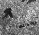
Date: 20 February 2007 Credit: NASA/JPL Image Notes: Full SAR strip obtained during the Titan-18 flyby, from which the two details released on 26 September 2006 were taken |
 |
|
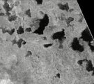
Date: 16 February 2007 Credit: NASA/JPL Video Notes: Animation of SAR mosaic of data gathered during three flyby's (incl. T18) over Titan's north polar region, with the up to 100 km wide radar-dark patches |
 |
|
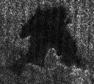
Date: 26 September 2006 Credit: NASA/JPL Image Notes: This view is part of a larger image centred near 74° N, 65° W. The lake measures roughly 20 km by 25 km |
 |
|
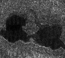
Date: 26 September 2006 Credit: NASA/JPL Image Notes: Image centred near 73° N, 46° W. The radar image shows two joined lakes, both 20-25 km across |
 |
