Titan Flyby - 9 October 2006
9 October 2006
Just 16 days after Titan-18, Cassini returns to Titan for its twentieth targeted encounter. The closest approach to Titan occurs on Monday, 9 October, at 00:23:27 UT at an altitude of 980 kilometers above the surface and at a speed of 6.0 kilometers per second. The latitude at closest approach is 60.7° N and the encounter occurs on orbit number 30.This encounter is set up with two manoeuvres: an apoapsis manoeuvre on 1 October, and an approach manoeuvre, on 6 October. This inbound encounter occurs about 2 days before Saturn closest approach.
Science Activities
- Composite Infrared Spectrometer (CIRS)
The CIRS observations emphasize the far-infrared part of the spectrum to map Titan's composition. CIRS will perform limb sounding with excellent vertical resolution and will also map surface temperatures. In addition, CIRS will obtain information on trace constituents in Titan's stratosphere and obtain information on CO, HCN, CH4 - Imaging Science Subsystem (ISS)
The ISS outbound observations will image the surface of Titan and attempt to track atmospheric and surface changes. ISS will also be looking at surface colour variations and monitor limb hazes - Cassini Radar (RADAR)
RADAR will be performing Radiometry, Scatterometry, and Synthetic Aperture measurements of Titan's surface at the high northern latitudes in an attempt to image lakes that were discovered during T16 (22 July 2006). RADAR will also be performing altimetry to get relative altitudes of Titan's surface - Magnetospheric and Plasma Science (MAPS)
MAPS will perform analysis of the plasma wake, ions escaping from Titan, and Titan's interaction with Saturn's magnetosphere down to a low altitude (980km)
Table of Events
20 September 2006
| Time UTC | Time wrt Titan-19 |
Activity |
| 20:22:00 | -18d21h | Start of sequence S24 which contains Titan-19 |
6 October 2006
| Time UTC | Time wrt Titan-19 |
Activity |
| 10:24:00 | -03d 07h | OTM #76 prime. Titan-19 minus 3 day targeting manoeuvre |
7 October 2006
| Time UTC | Time wrt Titan-19 |
Activity |
| 10:24:00 | -02d 07h | OTM #76 backup |
8 October 2006
| Time UTC | Time wrt Titan-19 |
Activity |
| 19:24:00 | -22h 06m | Start of the TOST segment |
| 19:24:00 | -22h 06m | Turn cameras to Titan |
| 19:54:00 | -21h 36m | Deadtime, 22 minutes long; used to accommodate changes in flyby time |
| 20:16:07 | -21h 14m | Titan atmospheric observations. Obtain information on the thermal structure of Titan's stratosphere |
9 October 2006
| Time UTC | Time wrt Titan-19 |
Activity |
| 02:30:07 | -15h 00m | Titan limb observations. Search Titan's nightside for atmospheric lighting and auras |
| 12:10:07 | -05h 20m | Titan inbound RADAR radiometry observations |
| 12:10:07 | -05h 20m | Titan Inbound RADAR scatterometry observations |
| 16:38:07 | -00h 52m | Transition to thrusters, which are needed to compensate for Titan atmosphere torque and target motion compensation |
| 17:00:07 | -00h 30m | Titan inbound RADAR altimetry observations. Determine altitude of Titan's surface while pointing nadir |
| 17:15:07 | -00h 15m | Low-res and hi-res Synthetic Aperture Radar of Titan's surface. Determine Titan surface features. T-19 includes a search for lakes on Titan at the high northern latitudes |
| 17:30:07 | +00h 00m | Titan-19 flyby closest approach. Altitude = 980 km, speed = 6 kms-1, high phase inbound, 81° phase at closest approach, low phase outbound |
| 17:45:07 | +00h 15m | Titan outbound RADAR altimetry observations. Determine altitude of Titan's surface while pointing nadir |
| 18:00:07 | +00h 30m | Transition to reaction wheels; used for greater spacecraft stability |
| 18:09:00 | +00h 39m | Descending ring plane crossing |
| 18:22:07 | +00h 52m | Titan outbound RADAR scatterometry observations |
| 18:45:07 | +01h 15m | Titan outbound RADAR radiometry observations |
| 22:50:07 | +05h 20m | Titan surface observations. Full disk observations for surface and atmospheric mapping |
10 October 2006
| Time UTC | Time wrt Titan-19 |
Activity |
| 09:21:07 | +15h 51m | Deadtime, 9 minutes long; used to accommodate changes in flyby time |
| 09:30:00 | +16h 00m | Turn to Earth-Line |
| 10:00:00 | +16h 30m | Begin playback of T19 data, Goldstone 70M + 34M array |
| 19:00:00 | +01d 01h | End playback of T19 Data |
12 October 2006
| Time UTC | Time wrt Titan-19 |
Activity |
| 22:59:00 | +02d 05h | Saturn periapse, R = 5.5 RS, lat = -29°, phase = 14° |
Observation Results
Cassini Instrument: Synthetic Aperture Radar (SAR)
|
Date: 16 February 2007 Credit: NASA/JPL Video Notes: Animation of SAR mosaic of data gathered during three flyby's over Titan's north polar region, with the up to 100 km wide radar-dark patches. |
 |
|
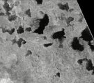
Date: 12 October 2006 Credit: NASA/JPL Image Notes: Radar image of Titan's terrain at high (73°) northern lattitudes, showing what is most likely a hydrocarbon lake. Several dark channels can be seen. |
 |
|
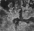
Date: 12 October 2006 Credit: NASA/JPL Image Notes: Radar image of Titan's terrain at high (80°) northern lattitudes, showing most likely hydrocarbon lakes with complex shapes and very dark colours. |
 |
