Titan Flyby - 12 December 2006
7 December 2006
After 48 days Cassini returns to Titan for its twenty-second targeted encounter, Titan-21. The closest approach to Titan occurs on Tuesday, 12 December at 11:41:31 UT, at an altitude of 1000 km above the surface and at a speed of 5.9 kilometres per second. The latitude at closest approach is 43.9° N (over the uncharted area known only as 'Belet') and the encounter occurs on orbit number 35.This encounter is set up with two manoeuvres: an apoapsis manoeuvre on 26 November, and an approach manoeuvre, scheduled for 9 December. This inbound encounter occurs about 3 days before Saturn closest approach.
Science Activities
- Cassini Radar (RADAR)
RADAR obtains SAR (Synthetic Aperture RADAR) imagery of the poorly-covered northern mid-latitude trailing hemisphere, which may include some areas of dunes. This is the least explored area on Titan to date. Observations also include radiometry and scatterometry to build up southern hemisphere coverage. - Ultraviolet Imaging Spectrograph (UVIS)
UVIS has a EUV-FUV observation, one of several throughout the tour, to image Titan at a variety of phase angles. These are used to investigate the scattering properties of high altitude aerosols, the latitudinal distribution of acetylene, methane, and some other hydrocarbons, and to look for auroral emissions. UVIS also observes an occultation of the star Alpha Per. Stellar occultations provide detailed vertical profiles of some hydrocarbons and haze in the altitude range 300 to 1500 kilometres. Each occultation samples a different latitude and different time of day so we gradually build up a 3-dimensional picture over the long term by observing many occultations. - Imaging Science Subsystem (ISS)
The ISS outbound and inbound observations will image the surface of Titan and attempt to track atmospheric and surface changes. ISS will also be looking at surface colour variations and monitor limb hazes. - Magnetosphere and Plasma Science (MAPS) Working Group
Analysis of plasma wake, ions escaping from Titan, and Titan's interaction with Saturn's magnetosphere down to a low altitude (1000 kilometres). INMS specifically will be looking at the atmospheric and ionospheric thermal structure of Titan's atmosphere.
Table of Events
24 November 2006
| Time UTC | Time wrt Titan-21 |
Activity |
| 16:30:00 | -17d 19h | Start of sequence S26 which contains Titan-21 (T21) |
30 November 2006
| Time UTC | Time wrt Titan-21 |
Activity |
| 13:44:00 | -11d 22h | Descending ring plane crossing |
3 December 2006
| Time UTC | Time wrt Titan-21 |
Activity |
| 00:39:00 | -09d 11h | Ascending ring plane crossing |
9 December 2006
| Time UTC | Time wrt Titan-21 |
Activity |
| 06:32:00 | -03d 05h | OTM #82 prime; Titan-21 minus 4 day targeting manoeuvre |
10 December 2006
| Time UTC | Time wrt Titan-21 |
Activity |
| 06:32:00 | - 02d 05h | OTM #82 backup |
11 December 2006
| Time UTC | Time wrt Titan-21 |
Activity |
| 15:17:00 | - 20h 24m | Start of the TOST segment |
| 15:17:00 | - 20h 24m | Turn cameras to Titan |
| 15:47:00 | - 19h 54m | Deadtime, 22 minutes long; used to accommodate changes in flyby time |
| 16:08:31 | - 19h 33m | Titan atmospheric observations. Obtain information on the thermal structure of Titan's stratosphere |
12 December 2006
| Time UTC | Time wrt Titan-21 |
Activity |
| 02:41:31 | - 09h 00m | Titan limb observations. Search Titan's nightside for atmospheric lightning and auras |
| 04:11:31 | - 07h 30m | Titan atmospheric observations. Search Titan's nightside exobase to dayside exobase |
| 10:31:31 | - 01h 10m | Stellar occultation. Observe the star Alpha Per as it is observed passing through Titan's atmosphere |
| 10:57:31 | - 00h 44m | Transition to thrusters. The thrusters are needed to compensate for Titan's atmosphere torque and target motion compensation |
| 11:18:31 | - 00h 23m | Sample Titan's upper atmosphere. INMS will attempt to determine atmospheric and ionospheric thermal structure. |
| 11:41:31 | + 00h 00m | Titan-21 flyby closest approach. Altitude = 1000 km, speed = 5.9 kms-1; high phase inbound, 125° phase at closest approach, low phase outbound |
| 11:41:31 | + 00h 00m | Titan outbound RADAR imaging. RADAR will obtain Synthetic Aperture RADAR (SAR) images of Titan's surface |
| 11:56:31 | + 00h 15m | Titan outbound RADAR altimetry observations. Determine altitude of Titan's surface while the spacecraft is pointing nadir |
| 12:10:00 | + 00h 29m | Descending ring plane crossing |
| 12:11:31 | + 00h 30m | Transition to reaction wheels. The wheels are used for greater spacecraft stability |
| 12:33:31 | + 00h 52m | Titan outbound RADAR scatterometry observations |
| 13:18:31 | + 01h 37m | Titan outbound RADAR radiometry observations |
| 15:41:31 | + 04h 00m | Full disk observations of Titan for surface and atmospheric mapping |
13 December 2006
| Time UTC | Time wrt Titan-21 |
Activity |
| 01:09:31 | + 13h 28m | Deadtime, 5 minutes long; used to accommodate changes in flyby time |
| 01:15:00 | + 13h 34m | Turn to Earth-line |
| 01:36:00 | + 13h 55m | Begin playback of T21 data. Madrid 34M handover to Goldstone 70M |
| 12:18:00 | + 01d 01h | End playback of T21 data |
14 December 2006
| Time UTC | Time wrt Titan-21 |
Activity |
| 00:02:00 | + 02d 12h | Saturn periapse. R = 7.6 RS, latitude = -37°, phase = 23° |
Observation Results
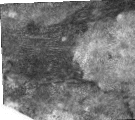
Cassini Instrument: Synthetic Aperture Radar (SAR)
|
Date: 12 January 2007 Credit: NASA/JPL Image Notes: Two views (11 Dec. 2006 (T21), 29 Oct. 2005 (T8)) of a field of dunes located near 290° W, 9.4° S. Differences are due to change in the SAR illumination angle, revealing the surface make-up |
 |
Last Update: 1 September 2019
