Titan Flyby - 28 December 2006
27 December 2006
Just 16 days after Titan-21, Cassini returns to Titan for its twenty-third targeted encounter. During this last flyby of the year, Titan's gravity field will be measured by Cassini's radio science instruments in search for a potential subsurface ocean. The closest approach to Titan occurs on Thursday, 28 December, at 10:05:22 UTC at an altitude of 1300 kilometres above the surface and at a speed of 5.9 kilometres per second. The latitude at closest approach is 40.2° N and the encounter occurs on orbit number 36.This encounter is set up with two manoeuvres: an apoapsis manoeuvre on 20 December and an approach manoeuvre, scheduled for 25 December. This inbound encounter occurs about 3 days before Saturn closest approach.
Science Activities
- Radio Science Subsystem (RSS)
The RSS observations will track the spacecraft from Earth before, during, and after closest approach to Titan. RSS will obtain Doppler and ranging data to help deduce details of Titan's gravity field. Also, RSS will attempt to determine the existence of an internal ocean by measuring the dynamic Love number, k2, of Titan. - Composite Infrared Spectrometer (CIRS)
T22 is a far-infrared focused flyby for CIRS. During the flyby CIRS will obtain two surface temperature maps, aimed to detect surface temperature variations in a window region near 500cm-1 (20 μm). In addition two composition integrations will be performed, designed to map the spatial variation of CO, H2O, and HCN via far-infrared rotational lines. - Imaging Science Subsystem (ISS)
High resolution coverage of Tsegihi.
Table of Events
24 November 2006
| Time UTC | Time wrt Titan-22 |
Activity |
| 16:30:00 | - 33d 18h | Start of sequence S26 which contains Titan-22 |
12 December 2006
| Time UTC | Time wrt Titan-22 |
Activity |
| 12:10:00 | - 15d 22h | Descending ring plane crossing |
15 December 2006
| Time UTC | Time wrt Titan-22 |
Activity |
| 10:37:00 | - 12d 23h | Ascending ring plane crossing |
25 December 2006
| Time UTC | Time wrt Titan-22 |
Activity |
| 05:34:00 | - 03d 05h | OTM #85 prime, Titan-22 minus 3 day targeting manoeuvre |
26 December 2006
| Time UTC | Time wrt Titan-22 |
Activity |
| 05:19:00 | - 02d 05h | OTM #85 backup |
27 December 2006
| Time UTC | Time wrt Titan-22 |
Activity |
| 14:19:00 | - 19h 46m | Turn cameras to Titan |
| 14:49:00 | - 19h 16m | Deadtime, 15 minutes long; used to accommodate changes in flyby time |
| 15:04:22 | - 19h 01m | Titan atmospheric observations. Obtain information on the structure of Titan's stratosphere |
28 December 2006
| Time UTC | Time wrt Titan-22 |
Activity |
| 01:35:22 | - 08h 30m | Titan gravity field determination; RSS Doppler and ranging data |
| 04:35:22 | - 05h 30m | Titan atmospheric observations. Obtain information on surface & tropopause temperatures |
| 07:35:22 | - 02h 30m | Titan gravity field determination; RSS Doppler and ranging data |
| 10:05:22 | + 00h 00m | Titan-22 flyby closest approach time. Altitude = 1300 km, speed = 5.9 kms-1; low phase inbound, 62° phase at closest approach, high phase outbound |
| 11:35:22 | + 01h 30m | ISS Imaging NAC regional map |
| 13:35:22 | + 03h 30m | Titan atmospheric observations. Obtain information on surface and tropopause temperatures |
| 15:35:22 | + 05h 30m | Titan gravity field determination; RSS Doppler and ranging data. |
| 18:35:22 | + 08h 30m | Titan atmospheric observations. Obtain information on trace constituents in Titan's stratosphere |
| 21:05:22 | + 11h 00m | Deadtime, 13 minutes 38 seconds long; used to accommodate changes in flyby time |
| 21:19:00 | + 11h 14m | Turn to Earth-line |
| 21:19:00 | + 11h 14m | Begin playback of T22 data. Madrid 34M |
29 December 2006
| Time UTC | Time wrt Titan-22 |
Activity |
| 03:54:00 | + 17h 49m | Continue playback of T22 data. Goldstone 70M |
| 06:49:00 | + 20h 44m | End playback of T22 data |
31 December 2006
| Time UTC | Time wrt Titan-22 |
Activity |
| 05:18:00 | + 02d 19h | Saturn periapse. R = 9.8 Rs, lat= -44°, phase = 31° |
Observation Results
Cassini Instrument: Visual and Infrared Mapping Spectrometer (VIMS)
|
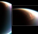
Date: 1 February 2007 Credit: NASA/JPL/University of Arizona Image Notes: Huge cloud system covering Titan's north pole down to latitude ~62° N. Composite view of three wavelengths: 2 μm (blue), 2.7 μm (green), and 5 μm (red). |
 |
Cassini Instrument: Imaging Science Subsystem (ISS)
|
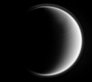
Date: 2 February 2007 Credit: NASA/JPL/Space Science Institute Image Notes: Ultraviolet view with narrow-angle camera, showing a banded pattern in the stratosphere where super-rotation is strong. Scale ~8 km/pixel. |
 |
