Titan Flyby - 22 February 2007
21 February 2007
On Thursday, 22 February 2007, Cassini returns to Titan for its twenty-sixth targeted encounter (T25). The highest inclination of the current mission phase (180 Degree Transfer phase) has been reached, with the inclination now starting to be lowered again. This is the highest Cassini will be until spring of 2008, when the mission will be in the High Inclination phase.This flyby also starts a series of outbound (from Saturn) encounters with Titan - from T25 to T34. Cassini's flybys of Titan have been on a series of inbound (to Saturn) encounters since T16 (22 July 2006).
The closest approach to Titan occurs at 03:12:24 UT, and at an altitude of 1000 kilometres above the surface with a speed of 6.2 kilometres per second. The latitude at closest approach is 30 degrees and the encounter occurs on orbit number 39. The data will be played back on Friday, 23 February 2007.
This encounter is set up with two manoeuvres: an apoapsis manoeuvre on 7 February, and an approach manoeuvre, scheduled for 19 February. The flyby occurs about two days before Saturn closest approach.
Science Activities
- Cassini Radar (RADAR)
A full RADAR prime pass, from roughly 5 hours before closest approach to ~5 hours after closest approach. The central +/- 15 minutes is the high resolution imaging of Titan's surface by SAR (Synthetic Aperture RADAR). This RADAR SAR swath crosses six swaths from previous flybys (TA, T3, T16, T18, T19, and T23). There has been only one other set of criss-crossing SAR swaths, T23 over T8, so this is major. T25 also covers high northern latitude lake territory, above Senkyo and Belet, and will try to extend the SAR observations for a few extra minutes to observe the Hotei Arcus feature - all within +/- 20 minutes of closest approach. RADAR rounds out the time with standard radiometry, scatterometry, and altimetry. - Imaging Science Subsystem (ISS)
The ISS will image new territory. The area north of Belet, Adiri, and Dilmun will be observed over the next several flybys with some of the highest resolution observations coming in the next flyby, T26. Medium resolution global map observations will be made at 5 hours after closest approach during T25. - Magnetospheric and Plasma Science (MAPS)
T25 is an upstream, inner flank transition flyby with the closest approach near the inner flank/wake transition area. It is the first flyby with a good chance to find itself in the Saturnian magnetosheath or even the solar wind - because of the unique local time (near noon). If this happens, the MAPS instruments will actually be observing a wake crossing. - Composite Infrared Spectrometer (CIRS)
The highlight for the infrared instrument is the mid-IR limb temperature map to be obtained during T25, designed to measure the altitude variation of temperature with latitude/longitude. CIRS aligns it slit at normal to the surface and passes from equator to pole. These observations are repeated at regular intervals throughout the mission to search for seasonal changes. They are also used for some limb compositional studies despite low spectral resolution.
Table of Events
7 February 2007
| Time UTC | Time wrt Titan-25 |
Activity |
| 02:37:00 | -15d 01h | OTM #93, apoapsis manoeuvre |
17 February 2007
| Time UTC | Time wrt Titan-25 |
Activity |
| 10:52:00 | -04d 16h | Start of sequence S28 that contains T25 |
19 February 2007
| Time UTC | Time wrt Titan-25 |
Activity |
| 01:37:00 | -03d 02h | OTM #94, T25 minus 3 day targeting manoeuvre |
| 11:49:50 | -02d 15h | Saturn periapse. R= 15.6 RS, latitude= -58°, phase= 59° |
21 February 2007
| Time UTC | Time wrt Titan-25 |
Activity |
| 10:37:00 | -16h 39m | Start of TOST Segment |
| 10:37:00 | -16h 39m | Turn cameras to Titan |
| 11:23:25 | -15h 48m | ISS nighttime atmospheric observations, search for and monitor lightning/aurora |
| 12:12:24 | -15h 00m | Mid-IR atmospheric observations. Obtain information on the thermal structure of Titan's stratosphere. Slew across disk at 4 microrad/s |
| 14:12:24 | -13h 00m | Far-IR atmospheric observations. Integrate at airmass of 1.5 to 2.0 |
| 17:12:24 | -10h 00m | ISS observations. Particle properties, vertical distributions ~6 km/px. 0.6 Mbit/frame with 2×2 summing |
| 18:12:24 | -09h 00m | Mid-IR atmospheric observations. Obtain information on trace constituents in Titan's stratosphere. Integrate on limb at two positions |
| 22:02:24 | -05h 10m | Turn HGA to Titan |
| 22:24:24 | -04h 48m | RADAR inbound radiometry and scatterometry. Observe surface properties (roughness and composition) |
22 February 2007
| Time UTC | Time wrt Titan-25 |
Activity |
| 02:20:24 | -00h 52m | Transition to thrusters. Thrusters are needed to compensate for Titan atmosphere torque and target motion compensation |
| 02:42:24 | -00h 30m | RADAR inbound altimetry and SAR. Accurate measurements of altitude of Titan's surface. Surface features determination with SAR |
| 03:12:24 | +00h 00m | Titan-25 Flyby Closest approach Time. Altitude = 1000 km, speed = 6.2 kms-1, lit outbound and 161° at closest approach, local Saturn time = 13.8 hours (near noon), magnetospheric location = flank in, sub-spacecraft latitude and longitude at closest approach is 30° by 16° west |
Observation Results
Cassini Instrument: Synthetic Aperture Radar (SAR)
|
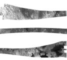
Date: 13 March 2007 Credit: NASA/JPL Image Notes: Complete radar swath of this flyby. The end that covers the highest northern latitudes, also has the largest radio dark patches, most likely lakes/seas. |
 |
|
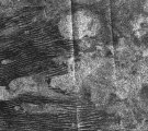
Date: 1 March 2007 Credit: NASA/JPL Image Notes: Radar image of dunes and radio-bright features at Titan's equator. The interaction between the two feature types will help in determining their nature. |
 |
|
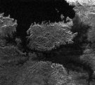
Date: 27 February 2007 Credit: NASA/JPL Image Notes: Radar image of an island (~90km across) in the middle of one of Titan's larger lakes imaged to date. The image is centred at 310° W and 79° N. |
 |
Cassini Instrument: Imaging Science Subsystem (ISS)
|
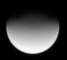
Date: 30 March 2007 Credit: NASA/JPL/Space Science Institute Image Notes: Narrow-angle camera ultraviolet image, showing bands of clouds in Titan's fast rotating stratosphere at high northern latitudes |
 |
