Titan Flyby - 10 April 2007
5 April 2007
Fifteen days after the previous flyby (T27), Cassini returns to Titan for its twenty-ninth targeted encounter. The closest approach to Titan occurs on Tuesday, 10 April, at 22:58 UTC at an altitude of 990 kilometres above the surface and at a speed of 6.2 kilometres per second. The latitude at closest approach is 50.4° N and the encounter occurs on orbit number 42.This encounter is set up with two manoeuvres: an apoapsis manoeuvre on 2 April, and a Titan approach manoeuvre, scheduled for 7 April. This is the fourth in a series of outbound (from Saturn) Titan encounters (First: T25, 22 February 2007. Last: T33, 29 June 2007). The flyby occurs about two days after Saturn closest approach.
Science Activities
- Cassini Radar (RADAR)
The T25 encounter revealed a fascinating feature: an island, in the middle of one of one of Titan's larger radar dark areas believed to be hydrocarbon lakes. The T28 flyby will give the RADAR team another scatterometry look at that island from a slightly different viewpoint, crossing over previous scatterometry tracks. Using the newer and older data sets, RADAR will be able to produce stereo images of the region. There's a possibility of seeing some changes over the few months since the last view of the area, but that's not expected - Imaging Science Subsystem (ISS)
The T28 flyby will show a region we haven't seen since approach in April of 2004. Now Cassini will see that area repeatedly, allowing us to examine how frequently clouds form in the area, and if their shapes are different than those seen elsewhere on Titan. ISS will use both regional and global-scale mosaics to monitor for changes on the surface and in the atmosphere, as well as attempt to see surface colour variations - Composite Infrared Spectrometer (CIRS)
CIRS continues global far-infrared observations at high northern latitudes. These high spectral resolution measurements are used to measure global distributions of hydrocarbons, nitriles, water, and CO, and to see how these distributions vary with latitude. The CIRS observations will also be used to search for new chemical species concentrated at the poles. High spectral resolution limb integrations are valuable for detecting weak species (including isotopes) and measuring the global abundances thereof, by virtue of long atmospheric path lengths - Ultraviolet Imaging Spectrograph (UVIS)
Spectral atmospheric mosaic across Titan - Visual and Infrared Mapping Spectrometer (VIMS)
Inbound, VIMS will make cloud mapping observations. On the outbound part of the flyby, VIMS will capture high-resolution surface observations
Table of Events
28 March 2007
| Time UTC | Time wrt Titan-28 |
Activity |
| 08:04:00 | -13d 15h | Start of sequence S29 which contains Titan-28 |
7 April 2007
| Time UTC | Time wrt Titan-28 |
Activity |
| 14:48:00 | -03d 08h | OTM #103 Prime. Titan-28 targeting manoeuvre |
8 April 2007
| Time UTC | Time wrt Titan-28 |
Activity |
| 04:57:29 | -02d 18h | Descending ring plane crossing |
| 16:21:34 | -02d 07h | Saturn periapse, R = 7.6 RS, lat = -39°, phase = 100° |
| 22:18:00 | -02d 01h | OTM #103 Backup |
10 April 2007
| Time UTC | Time wrt Titan-28 |
Activity |
| 07:03:00 | -15h 55m | Start of the TOST segment |
| 07:03:00 | -15h 55m | Turn cameras to Titan |
| 07:33:00 | -15h 25m | Deadtime, 16 minutes long. Used to accommodate changes in flyby time |
| 07:49:00 | -15h 09m | ISS Imaging. NAC nightside imaging |
| 07:58:00 | -15h 00m | Titan atmospheric observations. Obtain information on CO, HCN, CH4. Integrate on disk at airmass 1.5 - 2.0 |
| 09:58:00 | -13h 00m | Titan atmospheric observations. Cloud Map. Obtain 8 double resolution 64×64 images |
| 13:58:00 | -09h 00m | Titan atmospheric observations. UV mosaic across Titan |
| 17:48:00 | -05h 10m | New waypoint |
| 18:08:00 | -04h 50m | RADAR observations. Inbound radiometry of unique terrain at mid latitudes |
| 21:43:00 | -01h 15m | RADAR observations. Mid latitude scatterometry of unique terrain coverage of Titan |
| 22:06:00 | -00h 52m | Transition to thruster control |
| 22:28:00 | -00h 30m | RADAR observations. Altimetry measurements on the inbound leg of the T28 flyby |
| 22:42:00 | -00h 16m | RADAR observations. Low resolution SAR imaging on the inbound leg of T28 |
| 22:51:00 | -00h 07m | RADAR observations. High resolution SAR imaging during the T28 closest approach period |
| 22:58:00 | +00h 00m | Titan-28 flyby closest approach time. Altitude = 990 km, speed = 6.2 kms-1, 137° phase at closest approach |
| 23:01:11 | +00h 03m | Ascending ring plane crossing |
| 23:05:00 | +00h 07m | RADAR observations. Low resolution SAR imaging on the outbound leg of T28 |
| 23:14:00 | +00h 16m | RADAR observations. Altimetry measurements on the outbound leg of the T28 flyby |
| 23:27:00 | +00h 29m | New waypoint |
| 23:58:00 | +01h 00m | Titan surface observations. High-resolution cubes of Titan's surface |
11 April 2007
| Time UTC | Time wrt Titan-28 |
Activity |
| 00:58:00 | +02h 00m | ISS imaging. NAC regional map |
| 02:58:00 | +04h 00m | Titan atmospheric observations. Obtain information on trace constituents in Titan's stratosphere. Integrate on limb at two positions. |
| 03:58:00 | +05h 00m | ISS imaging. NAC global map |
| 07:34:00 | +08h 36m | ISS imaging. WAC photometry |
| 07:58:00 | +09h 00m | Titan atmospheric observations. Obtain information on CO, HCN, CH4. Integrate on disk at airmass 1.5 - 2.0 |
| 12:58:00 | +14h 00m | CIRS mid-infrared observations. Obtain information on the thermal structure of Titan's stratosphere. Slew across disk at 4 μrad/s |
| 20:12:00 | +21h 14m | Deadtime, 15 minutes long. Used to accommodate changes in flyby time |
| 20:27:00 | +21h 29m | Turn to Earth-line |
| 20:57:00 | +21h 59m | Playback of T28 data. Goldstone 70M |
Titan Ground Trace
 |
|
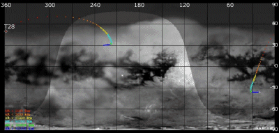
Image courtesy NASA/JPL/Space Science Institute |
The above image shows the ground trace of the Titan-28 flyby on a mosaic of Titan's surface, for a period of 32 hours around closest approach. The colour of the trace indicates Cassini's altitude above the surface. Blue: > 100 000 km, green: < 100 000 km, light blue: < 50 000, yellow: < 10 000 km, orange: < 5000 km, red: < 2000 km. The point of closest approach is marked T28. Cassini approaches Titan over the southern hemisphere, near latitude -35° at 16 hours before closest approach, and then continues to pass over Titan's northern hemisphere.
Observation Results
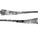
Cassini Instrument: Cassini Radar (RADAR)
|
Date: 27 July 2007 Credit: NASA/JPL Image Notes: More than 6700 km long radar swath (depicted here in two halves) obtained during this flyby, reaches up to 80° North latitude (see above ground trace) |
 |
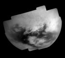
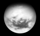
Cassini Instrument: Imaging Science Subsystem (ISS)
|
Date: 22 May 2007 Credit: NASA/JPL/Space Science Institute Image Notes: Mosaic of Titan's trailing hemisphere, centred near 220.7° W, 31.2° N. Images were obtained by combining data at 938 nm (infrared) & 619 nm (visual) |
 |
|
Date: 18 May 2007 Credit: NASA/JPL/Space Science Institute Image Notes: Narrow Angle Camera view from a distance of 1.2 million km, centred on 27.4° N latitude, obtained by combining data at 939 nm (infrared) & 619 nm (visual) |
 |
