Titan Flyby - 26 April 2007
23 April 2007
Sixteen days after Cassini's Titan-28 flyby, the spacecraft revisits Titan for its thirtieth targeted encounter. The closest approach to Titan occurs on Thursday, 26 April, at 21:32:58 UT, at an altitude of 980 kilometres above the surface and at a speed of 6.2 kilometres per second. The latitude at closest approach is 59.7° N and the encounter occurs on orbit number 43.This encounter is set up with two manoeuvres: an apoapsis manoeuvre on 18 April, and a Titan approach manoeuvre, scheduled for 23 April. This is the fifth in a series of outbound Titan encounters (first: T25, 22 February 2007; last: T33, 29 June 2007). The flyby occurs about two days after Saturn closest approach.
Science Highlights
- Cassini Radar (RADAR)
RADAR will perform observations of high latitude dark terrain. The team is particularly interested in learning how topography is guiding the wind, and identifying the orientation of the dunes. The inbound T29 RADAR observations will include mid latitude scatterometry of unique terrain coverage of Titan, altimetry, and low resolution SAR imaging. During the actual closest approach flyby, RADAR will conduct high resolution SAR imaging, filling in some of the white "gap" in RADAR observations of the lake region. The outbound leg observations will include low resolution SAR imaging, altimetry, and mid latitude scatterometry and radiometry of unique terrain coverage of Titan - Composite Infrared Spectrometer (CIRS)
CIRS will obtain a surface temperature map of a region in Titan's southern hemisphere, and will do limb mapping for hydrocarbons. Observations will yield information on surface & tropopause temperatures, and on the prevalence of tropospheric CH4. On the outbound leg of the encounter, CIRS will be looking for information on the thermal structure of Titan's stratosphere - Imaging Science Subsystem (ISS)
ISS will obtain a global map with resolution of 1 km per pixel, and will perform monitoring of the disk at 1.5 km per pixel at low solar phase angles. As in the previous Titan encounter, the ISS team will be monitoring for changes in the surface and atmosphere. Scientists will attempt to see if there are any surface colour variations, and will monitor limb hazes at a resolution of 1-3 km per pixel - Visual and Infrared Mapping Spectrometer (VIMS)
VIMS will obtain phase angle coverage of the northern hemisphere
Table of Events
28 March 2007
| Time UTC | Time wrt Titan-29 |
Activity |
| 08:04:00 | -29d 13h | Start of sequence S29 which contains Titan-29 |
23 April 2007
| Time UTC | Time wrt Titan-29 |
Activity |
| 21:16:00 | -03d 00h | OTM #106 Prime. Titan-29 targeting manoeuvre |
24 April 2007
| Time UTC | Time wrt Titan-29 |
Activity |
| 13:53:40 | -02d 08h | Descending ring plane crossing |
| 20:02:44 | -02d 02h | Saturn periapse. R = 5.7 RS, latitude = -32°, phase = 107° |
| 21:01:00 | -02d 01h | OTM #106 backup |
26 April 2007
| Time UTC | Time wrt Titan-29 |
Activity |
| 06:01:00 | -15h 31m | Start of the TOST segment |
| 06:01:00 | -15h 31m | Turn cameras to Titan |
| 06:31:00 | -15h 01m | Deadtime, 15 minutes 58 seconds long. Used to accommodate changes in flyby time |
| 06:46:58 | -14h 46m | Titan atmospheric observations. Mid-IR temperature map |
| 11:32:58 | -10h 00m | ISS Imaging. Photometry |
| 12:32:58 | -09h 00m | Titan atmospheric observations. VIMS regional cloud map |
| 16:32:58 | -05h 00m | Titan surface and atmospheric observations. Obtain information on surface & tropopause temperatures, and on tropospheric CH4 |
| 19:42:58 | -01h 50m | New waypoint |
| 19:42:58 | -01h 50m | RADAR observations. Mid latitude scatterometry of unique terrain coverage of Titan |
| 20:40:58 | -00h 52m | Transition to thruster control |
| 21:02:58 | -00h 30m | RADAR observations. Altimetry measurements on the inbound leg of the T29 flyby |
| 21:10:40 | -00h 22m | Solar Occultation. 22 minute duration |
| 21:12:14 | -00h 20m | Earth Occultation. 21 minute duration |
| 21:16:58 | -00h 16m | RADAR observations. Low resolution SAR imaging on the inbound leg of T29 |
| 21:25:58 | -00h 07m | RADAR observations. High resolution SAR imaging during the T29 closest approach period |
| 21:32:58 | +00h 00m | Titan-29 flyby closest approach time. Altitude = 980 km, speed = 6.2 kms-1, 130° phase at closest approach |
| 21:35:04 | +00h 03m | Ascending ring plane crossing |
| 21:39:58 | +00h 07m | RADAR observations. Low resolution SAR imaging on the outbound leg of T29 |
| 21:48:58 | +00h 16m | RADAR observations. Altimetry |
| 22:02:58 | +00h 30m | Transition off of thruster control |
| 22:24:39 | +00h 52m | RADAR observations. Mid latitude scatterometry |
| 22:49:58 | +01h 17m | RADAR observations. Radiometry observations |
27 April 2007
| Time UTC | Time wrt Titan-29 |
Activity |
| 02:23:00 | +04h 51m | New waypoint |
| 02:42:58 | +05h 10m | Titan regional map |
| 05:32:58 | +08h 00m | ISS Imaging. Global map |
| 06:12:58 | +08h 40m | ISS Imaging. Photometry |
| 06:32:58 | +09h 00m | Titan atmospheric observations. Obtain information on CO, HCN, CH4 |
| 08:32:58 | +11h 00m | ISS Imaging. Monitoring of surface and atmosphere |
| 10:32:58 | +13h 00m | Titan regional map |
| 11:32:58 | +14h 00m | Titan atmospheric observations. Obtain information on the thermal structure of Titan's stratosphere |
| 12:14:58 | +14h 42m | Deadtime, 15 minutes and two seconds long. Used to accommodate changes in flyby time |
| 12:30:00 | +14h 58m | Turn to Earth-line |
| 13:00:00 | +15h 28m | Playback of T29 data. Madrid 70M |
Titan Ground Trace
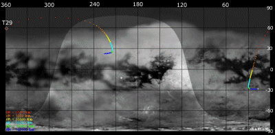 |
|
Image courtesy NASA/JPL/Space Science Institute |
The above image shows the ground trace of the Titan-29 flyby on a mosaic of Titan's surface, for a period of 32 hours around closest approach. The colour of the trace indicates Cassini's altitude above the surface. Blue: > 100 000 km, green: < 100 000 km, light blue: < 50 000, yellow: < 10 000 km, orange: < 5000 km, red: < 2000 km. The point of closest approach is marked T29. Cassini approaches Titan over the southern hemisphere, near latitude -30° at 16 hours before closest approach, and then continues to pass over Titan's northern hemisphere.
