Titan Flyby - 13 June 2007
12 June 2007
This week, Cassini returns to Titan for its thirty-third targeted encounter with Saturn's largest moon: Titan-32. The closest approach to Titan occurs on Wednesday, 13 June, at 17:46:11 UTC at an altitude of 975 kilometres above the surface and at a speed of 6.2 kilometres per second. The latitude at closest approach is 84.5° N and the encounter occurs on orbit number 46.This encounter is set up with two manoeuvres: an apoapsis manoeuvre on 5 June, and a Titan approach manoeuvre, which was scheduled for 10 June. This is the eighth in a series of outbound Titan encounters (first: T25, 22 February 2007; last: T33, 29 June 2007). The flyby occurs just under two days after Saturn closest approach.
Science Highlights
- Ion and Neutral Mass Spectrometer (INMS)
T32 will be the highest latitude Titan pass on which INMS will be in the driver's seat as the prime instrument. It is the only pass that occurs close to midnight local time, on the ram side of Titan, while Titan is on the Sun lit side of Saturn. This is a magnificent opportunity for in situ science of Titan's atmosphere in this unique geometry - Imaging Science Subsystem (ISS)
ISS conducts high-resolution (104-240 m/pixel) imaging and global-scale mapping of the bright-dark boundary. There will also be a full-disk, colour mosaic (centred at 1.7° N, 219° W) at 1.4-1.6 km/pixel resolution - Visual and Infrared Mapping Spectrometer (VIMS)
VIMS carries out high-resolution mapping of Titan's north pole. Observations include global mapping and monitoring for temporal changes. VIMS will also carry out a hot spot and lightning search - Composite Infrared Spectrometer (CIRS)
CIRS will continue to search for new species in the far-IR, in the far north. CIRS will also map temperatures in the upper troposphere across the north polar region, and in the stratosphere around approximately 1/4 of the disk. CIRS also gains the chance to map the distribution of aerosols on the limb in detail - Ultraviolet Imaging Spectrograph (UVIS)
UVIS will observe a solar ingress occultation. The observation samples mid-southern latitudes (near 50° south). Solar occultations are observed with the UVIS EUV channel which measures H, H2, N, N2 and some hydrocarbons from the exobase (the altitude where molecules or atoms can escape to space just from their thermal velocity because there are not enough atoms or molecules above them to stop them by collisions, near 3000 km to about 600 km altitude)
Table of Events
10 June 2007
| Time UTC | Time wrt Titan-32 |
Activity |
| 18:10:00 | -02d 24h | OTM #115 prime. Titan-32 targeting manoeuvre. |
11 June 2007
| Time UTC | Time wrt Titan-32 |
Activity |
| 03:10:00 | -02d 15h | Start of Sequence S31 which contains Titan-32 |
12 June 2007
| Time UTC | Time wrt Titan-32 |
Activity |
| 09:10:00 | -02d 09h | OTM #115 backup |
| 23:30:13 | -01d 18h | Descending ring plane crossing |
13 June 2007
| Time UTC | Time wrt Titan-32 |
Activity |
| 00:45:24 | -01d 17h | Saturn periapse, R = 2.7 RS, lat = -9°, phase = 123° |
| 02:54:00 | -14h 52m | Start of the TOST segment |
| 02:54:00 | -14h 52m | Turn cameras to Titan |
| 03:24:00 | -14h 22m | Deadtime, 15 minutes and 11 seconds long. Used to accommodate changes in flyby time |
| 03:39:11 | -14h 07m | Titan atmospheric observations. Obtain information on the thermal structure of Titan's stratosphere. Obtain information on CO, HCN, CH4 |
| 04:46:11 | -13h 00m | Titan atmospheric observations. Cloud map |
| 08:46:11 | -09h 00m | Titan atmospheric observations. Obtain vertical profiles of temperatures in Titan's stratosphere |
| 12:46:11 | -05h 00m | Titan surface observations. Scans across visible hemisphere to form spectral images |
| 14:46:11 | -03h 00m | ISS imaging. Search for and monitor lightning and aurora |
| 15:46:11 | -02h 00m | New waypoint |
| 16:12:11 | -01h 34m | Solar occultation observation. Measure transmission of EUV solar radiation through Titan's atmosphere. Obtain atmospheric vertical temperature distribution, and composition. Identify haze layers |
| 16:39:11 | -01h 07m | Operating mode transition |
| 17:01:37 | -00h 45m | Earth occultation, 40 minute duration |
| 17:02:09 | -00h 44m | Solar occultation, 39 minute duration |
| 17:03:35 | -00h 43m | Titan high resolution nightside imaging |
| 17:24:11 | -00h 22m | Magnetosphere and TOST campaign. Determine atmospheric and ionospheric composition and thermal structure |
| 17:42:19 | -00h 04m | Ascending ring plane crossing. Determine atmospheric and ionospheric composition and thermal structure |
| 17:46:11 | +00h 00m | Titan-32 Flyby Closest Approach Time. Altitude = 975 km, speed = 6.2 kms-1, 107° phase at closest approach |
| 18:01:11 | +00h 15m | Turn to limb |
| 18:08:11 | +00h 22m | Operating mode transition |
| 18:32:11 | +00h 46m | Titan atmospheric observations. Vertical temperature sounding of Titan's tropopause and stratosphere |
| 18:48:11 | +01h 02m | Titan surface observations. High resolution regional mapping |
| 19:46:11 | +02h 00m | New waypoint |
| 20:04:11 | +02h 18m | Titan atmospheric observations. Obtain information on both surface and tropopause temperatures, and on tropospheric CH4 |
| 22:46:11 | +05h 00m | Titan atmospheric observations. Medium resolution global mapping |
14 June 2007
| Time UTC | Time wrt Titan-32 |
Activity |
| 00:46:11 | +07h 00m | ISS imaging. Global map |
| 02:46:11 | +09h 00m | Titan atmospheric observations. Obtain information on CO, HCN, CH4 |
| 04:46:11 | +11h 00m | ISS imaging. Monitoring for surface/atmosphere changes. Attempt to see surface colour variations. Monitor limb hazes |
| 06:46:11 | +13h 00m | Titan surface observations. Regional map |
| 07:46:11 | +14h 00m | Titan atmospheric observations. Obtain information on the thermal structure of Titan's stratosphere |
| 10:01:11 | +16h 15m | Deadtime, 15 minutes and 7 seconds long. Used to accommodate changes in flyby time |
| 10:17:00 | +16h 31m | Turn to Earth-line |
| 10:47:00 | +17h 01m | Playback of T32 data. Madrid 70M and 34M |
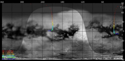
Titan Ground Trace
 |
|
Image courtesy NASA/JPL/Space Science Institute |
The above image shows the ground trace of the Titan-32 flyby on a mosaic of Titan's surface, for a period of 32 hours around closest approach. The colour of the trace indicates Cassini's altitude above the surface. Blue: > 100 000 km, green: < 100 000 km, light blue: < 50 000, yellow: < 10 000 km, orange: < 5000 km, red: < 2000 km (not reached during this flyby). The point of closest approach is marked T32. Cassini approaches Titan over the southern hemisphere, near latitude -9° (lower right in this image) at 16 hours before closest approach, and then continues to pass over Titan's northern hemisphere.
Observation Results
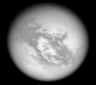
Cassini Instrument: Imaging Science Subsystem (ISS)
|
Date: 31 July 2007 Credit: NASA/JPL/Space Science Institute Image Notes: View of Titan's anti-Saturn side from ~157 000 km out at 939 nm. The bright Adiri region is seen in the centre. North on Titan is 26° clockwise from the top |
 |
