Titan Flyby - 31 August 2007
28 August 2007
This week, Cassini returns to Titan for its thirty-sixth targeted encounter with Saturn's largest moon: Titan-35. The closest approach to Titan occurs on Friday, 31 August, at 06:32:34 UT at an altitude of 3326 kilometres above the surface and at a speed of 6.1 kilometres per second. The latitude at closest approach is 63.5° N and the encounter occurs on orbit number 49.This encounter is set up with two manoeuvres: an apoapsis manoeuvre on 5 August, and a Titan approach manoeuvre, scheduled for 27 August. T35 kicks off a series of outbound encounters that will last until the end of the prime mission, and occurs less than two days before Saturn closest approach.
Science Activities
- Visual and Infrared Mapping Spectrometer (VIMS)
Data gathered by VIMS will be used to help understand the nature of Titan's north polar region and detect possible time-variable phenomena. The observations starting at 37 minutes before closest approach include a stellar occultation that will provide information on the structure and composition of Titan's atmosphere, the development and evolution of clouds, and characterization of the moon's haze. VIMS will also conduct high resolution mapping for geology and composition starting at two hours after closest approach. New territory will be covered with this pass. Interestingly, the north pole observation is on Titan's dark side, to get a view of the large northern lake at dusk. - Imaging Science Subsystem (ISS)
ISS will observe the Huygens probe landing site at high resolution and take images to provide regional-scale stereo coverage with images from earlier T28 and T31 flybys. The T35 observations will include regional and global-scale mosaics, with the regional image centred on an interesting circular feature. The whole hemisphere is targeted by the global mosaic. ISS will have coverage of similar areas at lower resolution during the T36 flyby. Series of flybys that cover the same area repeatedly are useful for monitoring time dependent phenomena. These observations will allow scientists to see if, for instance, clouds are appearing or disappearing, if there are patterns in weather, or if the weather has any correlations with Titan's surface features. Dwell (integration) times for these images are about 5-7 minutes long. Longer dwell times would be helpful, but would cut down on the amount of area that can be imaged during these opportunities. - Composite Infrared Spectrometer (CIRS)
CIRS observations will emphasize increasing time coverage at lower resolutions where the instrument has already covered Titan's disk, and increasing spatial coverage for regions missed so far. The instrument will collect vertical temperature profiles in Titan's stratosphere, and vertical sounding of stratospheric compounds on Titan, including H2O. In addition, CIRS will often ride along with UVIS EUV/FUV scans. At this point in the mission CIRS surface coverage is quite good with respect to latitude, but longitudinal coverage for temperature variation still needs to be improved. Spatial coverage for Far IR composition integrations is quite good; better spatial resolution will be able to tie the CIRS temperature maps to albedo observations from ISS and altimetry data from RADAR. - Ultraviolet Imaging Spectrograph (UVIS)
UVIS will be used to obtain spectral images of Titan in the EUV and FUV to map the aurora and dayglow, to map hydrocarbon absorption, and to measure scattering and absorption by aerosols in the stratosphere. Titan occults Sigma Sgr, and UVIS will use the observation opportunity for further atmospheric investigations. - Radio and Plasma Wave Science (RPWS)
RPWS continues its definitive search for lightning in Titan's atmosphere and for radio emissions from Titan, along with investigating ion pickup processes and ionospheric plasma temperature and density. Interestingly, RPWS observations have found no evidence to date for radio emissions, and have not detected terrestrial-type lightning. Probe scientists have seen interesting signatures in their data that could be lightning, but RPWS data don't support that conclusion yet.
Table of Events
11 August 2007
| Time UTC | Time wrt Titan-35 |
Activity |
| 23:20:00 | -19d 07h | Start of sequence S33 which contains Titan-35 |
27 August 2007
| Time UTC | Time wrt Titan-35 |
Activity |
| 13:20:00 | -03d 17h | OTM #124 Prime. Titan-35 targeting manoeuvre |
28 August 2007
| Time UTC | Time wrt Titan-35 |
Activity |
| 13:20:00 | -02d 17h | OTM #124 Backup |
29 August 2007
| Time UTC | Time wrt Titan-35 |
Activity |
| 07:22:55 | -01d 23h | Descending ring plane crossing |
| 13:02:32 | -01d 18h | Saturn periapse, R = 5.4 RS, lat = 0°, phase = 132° |
30 August 2007
| Time UTC | Time wrt Titan-35 |
Activity |
| 17:34:00 | -12h 58m | Start of the TOST segment |
| 20:49:00 | -09h 43m | Turn cameras to Titan |
| 21:19:00 | -09h 13m | Deadtime, 27 minutes and 20 seconds long. Used to accommodate changes in flyby time |
| 21:32:34 | -09h 00m | Titan atmospheric observations. Obtain vertical profiles of temperatures in Titan's stratosphere |
31 August 2007
| Time UTC | Time wrt Titan-35 |
Activity |
| 01:32:34 | -05h 00m | Titan atmospheric and surface observations. Obtain information on surface & tropopause temperatures, and on tropospheric CH4. |
| 04:32:34 | -02h 00m | Titan atmospheric observations. Obtain information on CO, HCN, CH4. Integrate on disk at airmass 1.5-2.0. |
| 05:32:34 | -01h 00m | Titan atmospheric observations. Temperature of the high atmosphere and vertical profiles of N, N2 and hydrocarbons at many latitudes |
| 05:55:34 | -00h 37m | Titan surface observations |
| 06:32:34 | +00h 00m | Titan-35 Flyby Closest Approach Time. Altitude = 3326 km, speed = 6.1 kms-1, 87° phase at closest approach |
| 06:32:34 | +00h 00m | Titan surface observations. High-resolution cubes of Titan's surface |
| 08:32:34 | +02h 00m | Titan surface observations. Regional map |
| 10:32:34 | +04h 00m | Titan atmospheric observations. Obtain information on surface & tropopause temperatures, and on tropospheric CH4 |
| 11:32:34 | +05h 00m | Titan surface observations. Global Map |
| 15:08:34 | +08h 36m | Titan atmospheric observations. Particle properties, vertical distributions ~6 km/px |
| 15:32:34 | +09h 00m | Titan atmospheric observations. Obtain information on CO, HCN, CH4. Integrate on disk at airmass 1.5-2.0 |
| 21:32:34 | +15h 00m | Titan atmospheric observations. Obtain information on the thermal structure of Titan's stratosphere |
1 September 2007
| Time UTC | Time wrt Titan-35 |
Activity |
| 03:32:34 | +21h 00m | Deadtime, 17 minutes and 26 seconds long. Used to accommodate changes in flyby time |
| 04:20:00 | +21h 48m | Turn to Earth-line |
| 04:20:00 | +21h 48m | Playback of T35 Data. Madrid 34M and Goldstone 70M |
Titan Ground Trace
 |
|
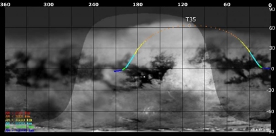
Image courtesy NASA/JPL/Space Science Institute |
The above image shows the ground trace of the Titan-35 flyby on a mosaic of Titan's surface, for a period of 32 hours around closest approach. The colour of the trace indicates Cassini's altitude above the surface. Blue: > 100 000 km, green: < 100 000 km, light blue: < 50 000, yellow: < 10 000 km, orange: < 5000 km, red: < 2000 km (not reached during this flyby). The point of closest approach is marked T35. Cassini approaches Titan over the equatorial region at 16 hours before closest approach (centre right in this image), and then continues to pass over Titan's northern hemisphere.
Observation Results
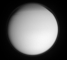
Cassini Instrument: Imaging Science Subsystem (ISS)
|
Date: 2 September 2007 Credit: NASA/JPL/Space Science Institute Image Notes: Narrow-angle camera view of Titan's high-altitude haze layer taken from a distance of ~ 1.3 million km in ultraviolet light centred at 338 nm |
 |
