Titan Flyby - 12 May 2008
9 May 2008
Monday 12 May, Cassini returns to Titan for the mission's forty-fourth targeted encounter: Titan-43. The closest approach occurs at 10:01:58 UT, at an altitude of 1000 kilometres above the surface and at a speed of 6.3 kilometres per second. The latitude at closest approach is 17.1° N and the encounter occurs on orbit number 67.This encounter is set up with two manoeuvres: an apoapsis manoeuvre on 25 April, and a Titan approach manoeuvre, scheduled for 8 May. T43 is the eighth in a series of outbound encounters that will last until the end of the prime mission, and occurs less than two days after Saturn closest approach. This is the first of two Titan northern hemisphere encounters that close out the prime mission.
Science Activities
- Cassini Radar (RADAR)
RADAR captures SAR imagery of the bright region Xanadu, only part of which was previously observed in T13. The RADAR team has targeted Hotei Arcus, as well as the possible cryovolcanic feature Tortola Facula (informally known as the 'Snail') which is seen near closest approach. T43 will also feature high-altitude SAR(1-2 km/pixel) of the west end of Tui Regio. This will be the first RADAR coverage of Tui Regio, which we know from VIMS observations to be compositionally distinct from the rest of Titan. Observations of the dunes northwest of Xanadu may show how wind is diverted around Xanadu. In combination with T13 data, T43 SAR may help measure Titan's topography and the possibly changing spin rate. - Ion and Neutral Mass Spectrometer (INMS)
INMS rides along with RADAR to get low latitude coverage in the north. - Composite Infrared Spectrometer (CIRS)
CIRS continues to extend spatial and temporal coverage of Titan, from low-spectral resolution disk maps to high spectral resolution nadir and limb integrations. Getting good time resolution is very important to allow for seasonal changes in the stratosphere to be detected, especially the expected break-up of the northern polar vortex in northern spring. During T43, CIRS will make a number of important maps on the outbound leg, including a far-IR surface/troposphere temperature scan from +2 to +5 hours, a mid-IR limb temperature map for stratospheric temperatures from +5 to +9 hours, and a complete mid-IR temperature map of the visible hemisphere, for inferring dynamics, winds and waves. CIRS also has two far-IR composition links to search for new molecular species in the far-IR and sub-mm ranges beyond the capability of Voyager IRIS. - Visual and Infrared Mapping Spectrometer (VIMS)
VIMS observations concentrate on determining time scales for cloud formation and dissipation. - Imaging Science Subsystem (ISS)
ISS will capture night side photometry. As the geometries of the T41 through T44 flybys are very similar, it will be possible to monitor how the clouds change in this region every few weeks. The instrument will utilize ride-along observations with CIRS. - Radio and Plasma Wave Science (RPWS)
As Titan is out 'in front' of Saturn, the T41 through T44 flybys put the spacecraft in an ideal location to have another opportunity to see Titan outside of Saturn's magnetosphere, in shocked solar wind ahead of the magnetosheath as happened on T32. It is interesting to duplicate the flyby geometry and look for shorter time-scale phenomena in Titan's plasma environment. This series of four flybys, especially T41 through T43, offer that opportunity.
Table of Events
19 April 2008
| Time UTC | Time wrt T-43 |
Activity |
| 07:18:00 | -23d 03h | Start of sequence S40 which contains Titan-43 |
8 May 2008
| Time UTC | Time wrt T-43 |
Activity |
| 21:00:00 | -03d 13h | OTM #154 Prime, Titan-43 targeting manoeuvre |
9 May 2008
| Time UTC | Time wrt T-43 |
Activity |
| 12:00:00 | -02d 22h | OTM #154 Backup |
| 23:35:35 | -02d 10h | Methone non-targeted flyby. Altitude = 95 865 km |
10 May 2008
| Time UTC | Time wrt T-43 |
Activity |
| 00:04:44 | -02d 10h | Descending Ring Plane Crossing |
| 00:05:52 | -02d 10h | Janus non-targeted flyby. Altitude = 120 801 km |
| 02:12:02 | -02d 08h | Saturn periapse, R = 4.293 RS, lat = -23°, phase = 150° |
11 May 2008
| Time UTC | Time wrt T-43 |
Activity |
| 22:30:00 | -11h 31m | Start of the TOST segment |
| 22:30:00 | -11h 31m | Turn cameras to Titan |
| 23:00:00 | -11h 01m | New waypoint |
| 23:00:00 | -11h 01m | Deadtime, 7 minutes and 58 seconds long. Used to accommodate changes in flyby time |
| 23:07:58 | -10h 54m | Titan atmospheric observations-CIRS. Obtain information on CO, HCN, CH4 |
12 May 2008
| Time UTC | Time wrt T-43 |
Activity |
| 00:01:58 | -10h 00m | Titan atmospheric observations-ISS. WAC photometry and NAC nightside imaging |
| 01:01:58 | -09h 00m | Titan surface observations-VIMS. Regional map |
| 04:54:58 | -05h 07m | Turn cameras to new waypoint |
| 05:12:58 | -04h 49m | New waypoint |
| 05:12:58 | -04h 49m | Titan surface observations-RADAR. Inbound radiometry of unique southeast territory, contiguous with T39 |
| 08:31:58 | -01h 30m | Titan surface observations-RADAR. Inbound scatterometry of unique southeast territory, contiguous with T39 |
| 09:09:58 | -00h 52m | Transition to thruster control |
| 09:10:58 | -00h 51m | Titan surface observations-RADAR. Inbound altimetry |
| 09:46:58 | -00h 15m | Titan surface observations-RADAR. Inbound low rate SAR |
| 09:54:58 | -00h 07m | Titan surface observations-RADAR. High rate SAR |
| 10:01:58 | +00h 00m | Titan-43 Flyby Closest Approach Time. Altitude = 1000 km, speed = 6.3 kms-1, 36° phase at closest approach |
| 10:08:58 | +00h 07m | Titan surface observations-RADAR. Outbound low rate SAR |
| 10:16:58 | +00h 15m | Titan surface observations-RADAR. Outbound altimetry |
| 10:30:45 | +00h 29m | Ascending ring plane crossing |
| 10:31:58 | +00h 30m | Transition off of thruster control |
| 10:53:58 | +00h 52m | Titan surface observations-RADAR. Outbound scatterometry of unique northwest territory, contiguous with T39 |
| 11:51:58 | +01h 50m | Turn cameras to new waypoint |
| 12:11:58 | +02h 10m | New waypoint |
| 12:11:58 | +02h 10m | Titan atmospheric observations-CIRS. Obtain information on surface & tropopause temperatures, and on tropospheric CH4 |
| 15:01:58 | +05h 00m | Titan atmospheric observations-CIRS. Obtain information on trace constituents in Titan's stratosphere. Integrate on limb at two positions |
| 19:01:58 | +09h 00m | Titan atmospheric observations-CIRS. Obtain information on CO, HCN, CH4 |
13 May 2008
| Time UTC | Time wrt T-43 |
Activity |
| 00:01:58 | +14h 00m | Turn to Earth-line |
| 00:31:58 | +14h 30m | Playback of T43 data. Goldstone 70 |
| 02:16:58 | +16h 15m | Turn cameras to new waypoint |
| 02:46:58 | +16h 45m | New waypoint |
| 02:46:58 | +16h 45m | Titan atmospheric observations-CIRS. Obtain information on the thermal structure of Titan's stratosphere |
| 09:16:58 | +23h 15m | Titan atmospheric observations-CIRS |
| 12:20:58 | +01d 02h | Deadtime, 23 minutes and 2 seconds long. Used to accommodate changes in flyby time |
| 12:44:00 | +01d 03h | Turn to Earth-line |
| 13:14:00 | +01d 03h | Playback of T43 data. Madrid 70 arrayed 11 |
Titan Ground Trace
 |
|
Image courtesy NASA/JPL/Space Science Institute |
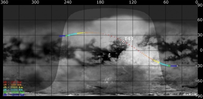
The above image shows the ground trace of the Titan-43 flyby on a mosaic of Titan's surface, for a period of 32 hours around closest approach (going from ~38° to ~255° longitude). The colour of the trace indicates Cassini's altitude above the surface. Blue: > 100 000 km, green: < 100 000 km, light blue: < 50 000, yellow: < 10 000 km, orange: < 5000 km, red: < 2000 km. The point of closest approach is marked T43 (Cassini at 1000 km altitude).
Observation Results
Cassini Instrument: Cassini Radar (RADAR)
|
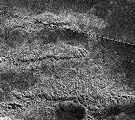
Date: 21 May 2008 Credit: NASA/JPL Image Notes: Three west-to-east oriented parallel ridges (~25km apart) located in the mountainous region Xanadu. Image is centred at 2°S, 127°W, resolution: ~300m. |
 |
|
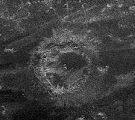
Date: 21 May 2008 Credit: NASA/JPL Image Notes: New crater discovered during this flyby. Only the fourth confirmed crater on Titan to date, with a diameter of ~112 km, located at 26°N, 200°W. |
 |
