Titan Fly-by - 21 May 2009
19 May 2009
On Thursday, 21 May, Cassini returns to Saturn's largest moon for the mission's fifty-sixth targeted encounter with Titan: T55. The closest approach to Titan occurs at 21:26:41 UTC at an altitude of 965 kilometres above the surface and at a speed of 6.0 kilometres per second. The latitude at closest approach is 22°S and the encounter occurs on orbit number 111.This encounter is set up with two manoeuvres: an apoapsis manoeuvre on 13 May, and a Titan approach manoeuvre, scheduled for 18 May. T55 is the fourth flyby in a series of eleven inbound encounters and the eleventh Titan encounter in Cassini's Equinox Mission. It occurs just over three days before Saturn closest approach.
Science Highlights
- Cassini Radar (RADAR)
The SAR swath sweeps down across the Shangri-La dunefields and into high Southern latitudes on Titan. This begins a sequence of near-parallel SAR swaths HiSAR north of Xanadu and over southern polar regions. - Ion and Neutral Mass Spectrometer (INMS)
On T55, INMS will be riding with RADAR, obtaining unique nightside coverage at low Southern latitudes. This fly-by provides unique coverage for the outer flank of Titan's magnetospheric interaction region. - Composite Infrared Spectrometer (CIRS)
During T55 CIRS will perform surface temperature mapping; continued composition integrations and obtain stratospheric temperature maps. - Visual and Infrared Mapping Spectrometer (VIMS)
On the inbound leg, the phase angle is much larger than 90° and VIMS ridealong observations will provide information on Titan's atmospheric composition. After closest approach, VIMS will observe from great distances Titan's South Pole region, riding along with CIRS. Only cloud monitoring will be possible. - Imaging Science Subsystem (ISS)
ISS will acquire a full-disk mosaic of eastern Tsegihi at high southern latitudes and ride along with CIRS to monitor clouds. - Ultraviolet Imaging Spectrograph (UVIS)
UVIS will obtain an image cube of Titan's atmosphere at extreme-, and far-ultraviolet wavelengths by sweeping its slit across the disk. These cubes provide spectral and spatial information on nitrogen emissions, H emission and absorption, absorption by simple hydrocarbons, and the scattering properties of haze aerosols. This is one of many such cubes gathered over the course of the mission to provide latitude and seasonal coverage of Titan's middle atmosphere and stratosphere. - Magnetospheric Imaging Instrument (MIMI)
MIMI will measure energetic ion and electron energy input to Titan's atmosphere. - Dual Technique Magnetometer (MAG)
T55 is another flank-out, post-dusk fly-by, with a minimum altitude of 965 kilometres. Therefore, the measurements will provide a description of the draping and the pileup of the external magnetic field around Titan on the nightside hemisphere. It will be also a good complement to T52, T53 and T54 in order to characterize the background field for a similar local time with respect to Saturn and different SKR longitudes. - Radio and Plasma Wave Science (RPWS)
RPWS will measure thermal plasmas in Titan's ionosphere and surrounding environment, search for lightning in Titan's atmosphere, and investigate the interaction of Titan with Saturn's magnetosphere.
Table of Events
5 May 2009
| Time UTC | Time wrt Titan-55 |
Activity |
| 07:16:00 | -16d 14h | Start of sequence S50 that contains Titan-55 |
18 May 2009
| Time UTC | Time wrt Titan-55 |
Activity |
| 13:45:00 | -03d 08h | OTM #196 prime. Titan-55 targeting manoeuvre |
19 May 2009
| Time UTC | Time wrt Titan-55 |
Activity |
| 13:44:00 | -02d 08h | OTM #196 backup |
21 May 2009
| Time UTC | Time wrt Titan-55 |
Activity |
| 06:14:00 | -15h 12m | Start of the TOST segment |
| 06:14:00 | -15h 12m | Turn cameras to Titan |
| 06:54:00 | -14h 32m | New waypoint |
| 06:54:00 | -14h 32m | Deadtime, 15 minutes and 49 seconds long. Used to accommodate changes in fly-by time |
| 07:09:49 | -14h 17m | Titan atmospheric observations - CIRS. Obtain information on the thermal structure of Titan's stratosphere |
| 08:26:41 | -13h 00m | Titan surface observations - VIMS. Cloud mapping |
| 12:26:41 | -09h 00m | Titan atmospheric observations - UVIS. Several slow scans across Titan's visible hemisphere to form spectral images |
| 18:56:41 | -02h 30m | RADAR. Inbound scatterometry |
| 20:14:41 | -01h 12m | Transition to thruster control |
| 20:15:41 | -01h 11m | RADAR. Inbound HiSAR |
| 20:56:41 | -00h 30m | RADAR. Inbound altimetry |
| 21:08:41 | -00h 18m | RADAR. Inbound and outbound SAR |
| 21:11:06 | -00h 15m | Earth occultation, 18 minute duration |
| 21:12:01 | -00h 14m | Solar occultation, 17 minute duration |
| 21:26:41 | +00h 00m | Titan-55 Fly-by Closest Approach Time. Altitude = 965 km, speed = 6.0 kms-1, 141° phase at closest approach |
| 21:44:41 | +00h 18m | RADAR. Outbound altimetry |
| 21:46:45 | +00h 20m | Descending ring plane crossing |
| 21:56:41 | +00h 30m | RADAR. Outbound HiSAR |
| 22:16:41 | +00h 50m | Transition off of thruster control |
| 22:38:22 | +01h 12m | RADAR. Outbound scatterometry |
| 23:56:41 | +02h 30m | Titan atmospheric observations - CIRS. Obtain information on surface & tropopause temperatures, and on tropospheric CH4. Scan or contiguous steps across disk |
22 May 2009
| Time UTC | Time wrt Titan-55 |
Activity |
| 02:26:41 | +05h 00m | Titan atmospheric observations - CIRS. Integrate on Titan's limb with arrays parallel to limb, paired detector mode, to maximize S/N for detection and characterization of trace gas species and isotopes |
| 06:26:41 | +09h 00m | Titan atmospheric observations - CIRS. Obtain information on CO, HCN, CH4. Integrate on disk at airmass 1.5-2.0 |
| 09:26:41 | +12h 00m | Titan surface observations-ISS. Monitoring for surface/atmosphere changes; attempt to see surface colour variations; monitor limb hazes, 1-3 km/px |
| 11:26:41 | +14h 00m | Titan atmospheric observations - CIRS. Obtain information on the thermal structure of Titan's stratosphere. |
| 19:26:41 | +22h 00m | Deadtime 52 minutes and 18 seconds long. Used to accommodate changes in fly-by time |
| 20:19:00 | +22h53m | Turn to Earth-line |
| 22:04:00 | +01d 01h | Playback of T55 data with Goldstone 34m ground station |
23 May 2009
| Time UTC | Time wrt Titan-55 |
Activity |
| 00:20:00 | +01d 03h | Playback of T55 data with Goldstone 70m ground station |
Observation Results
Cassini Instrument: Cassini Radar (RADAR)
|
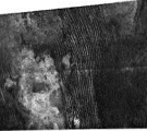
Release Date: 10 June 2009 Credit: NASA/JPL Image Notes: This 225 by 636 km view shows a pattern of dunes likely consisting of sand-sized particles made of organic material, shaped by local weather/terrain. |
 |
|
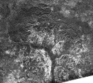
Release Date: 10 June 2009 Credit: NASA/JPL Image Notes: A 335 by 289 km view of a complex canyon system, likely carved into older terrain by the ample flow of liquid methane rivers; centred at 71°S, 240°W. |
 |
Cassini Instrument: Imaging Science Subsystem (ISS)
|
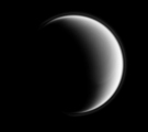
Release Date: 1 July 2009 Credit: NASA/JPL/Space Science Institute Image Notes: Wide-angle camera image over Titan's northern hemisphere, taken in violet light, revealing the hazes in the upper atmosphere as a thin halo around the moon |
 |
|
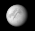
Release Date: 23 July 2009 Credit: NASA/JPL/Space Science Institute Image Notes: Near-infrared view of Titan with a 938 nm filter, looking toward Fensal and Aztlan, two dark areas near the equator. North is up, 38° counter-clockwise. |
 |