Titan Fly-by - 19 November 2008
18 November 2008
Sixteen days after its previous visit, Cassini once again approaches Saturn's moon Titan for the mission's forty-eighth targeted encounter. The closest approach to Titan occurs on Wednesday, 19 November, at 15:56:28 UTC at an altitude of 1022.6 kilometres above the surface and at a speed of 6.3 kilometres per second. The latitude at closest approach is 21.6° S and the encounter occurs on orbit number 93.This encounter is set up with two manoeuvres: an apoapsis manoeuvre on 12 November, and a Titan approach manoeuvre on 16 November. T47 is the eleventh in a series of outbound encounters and the third Titan encounter in Cassini's Equinox Mission. It occurs just under three days after closest approach to Saturn.
During this close fly-by, the VIMS instrument will perform its highest resolution imaging of the Huygens landing site to date, at a resolution of less than a kilometre per pixel.
Titan's atmosphere will also be under scrutiny, with the UVIS instrument making stellar occultation observations as Titan's atmosphere blocks light from the two stars eta Ursae Majoris (Alkaid) and beta Canis Majoris (Murzim).
Science Highlights
- Visual and Infrared Mapping Spectrometer (VIMS)
For the first time of the Cassini mission, VIMS will be able to image the Huygens landing site at closest approach with a resolution of less than a kilometre per pixel. It will cover areas that have already been observed with radar, allowing for a joint study of geological features including dunes and circular features that are either impact craters or volcanic calderas. Though we have a better understanding of Titan's motion, it is possible that its spin is not synchronous with its orbit around Saturn. If VIMS observations don't show the Huygens landing site, this will add to our understanding of Titan's spin rate. During the stellar occultations before and after closest approach, VIMS will get information on Titan's atmospheric composition. - Ultraviolet Imaging Spectrograph (UVIS)
UVIS will observe two stellar occultations (eta Ursae Majoris and beta Canis Majoris). These give vertical profiles of hydrocarbons and aerosols in the high stratosphere and mesosphere, a region that cannot be probed by other instruments. Over the course of Cassini's nominal and extended mission UVIS stellar occultations will sample about 12 latitudes and this sampling will help constrain photochemistry, dynamics and aerosol microphysical processes in the upper stratosphere and mesosphere. - Composite Infrared Spectrometer (CIRS)
On T47 CIRS focuses on limb sounding of Titan at low latitudes, designed to measure the spatial variations of trace gas species and isotopic ratios of C, H, N and O, yielding insights into the formation and ongoing evolution of the atmosphere. In addition, CIRS continues its campaign of mapping Saturn in the mid and far-infrared to obtain the spatial and temporal variation of temperature and more abundant hydrocarbon and nitrile molecules, which provide information on seasonal changes in weather, climate and chemistry that may be occurring. - Ion and Neutral Mass Spectrometer (INMS)
INMS will be trying something new: riding along with VIMS to measure the dayside ionosphere at low/equatorial southern latitudes. The instrument should get a good sampling of ions; it will miss corotation, but should see the boundary when we hit Titan's atmosphere, which is interesting for a variety of reasons. This fly-by is a first look at low equatorial southern latitudes. It's also a relatively rare dayside pass. - Imaging Science Subsystem (ISS)
ISS will carry out a global mapping and photometry of leading hemisphere and ride-along with VIMS for global- and regional-scale images. The areas included in the mapping are eastern Xanadu, including Hotei Arcus, the Xanadu-Fensal/Aztlan boundary, and western Tsegihi. - Magnetospheric Imaging Instrument (MIMI)
This should be a rare Titan encounter for MIMI for which the INCA FOV remains free of sunlight contamination throughout the pass, good for seeing the energetic ion absorption both inbound and outbound. It is also another opportunity for possibly encountering Titan outside the magnetopause, a condition we have, to date only seen for a partial encounter - Dual Technique Magnetometer (MAG)
T47 is a flank-out fly-by with a minimum altitude of just over 1000 km. The geometry of this fly-by makes it complementary to T46 in the study of the draping of the external magnetic field around Titan by covering the dayside hemisphere. T47 takes place in Saturn's near-noon sector (10.5 hours Saturn local time), where Titan could be found in the magnetosheath if the solar wind pressure is high. This is a first priority fly-by for MAG.
Table of Events
18 October 2008
| Time UTC | Time wrt T-47 |
Activity |
| 20:21:00 | -31d 20h | Start of sequence S45 which contains Titan-47 |
16 November 2008
| Time UTC | Time wrt T-47 |
Activity |
| 02:09:00 | -03d 14h | OTM #172 prime. Titan-47 targeting manoeuvre |
17 November 2008
| Time UTC | Time wrt T-47 |
Activity |
| 09:24:00 | -02d 07h | OTM #172 backup |
18 November 2008
| Time UTC | Time wrt T-47 |
Activity |
| 18:24:00 | -21h 32m | Start of the TOST segment |
| 18:24:00 | -21h 32m | Turn cameras to Titan |
| 18:24:00 | -21h 32m | New waypoint |
| 19:04:00 | -20h 52m | Deadtime, 15 minutes long. Used to accommodate changes in fly-by time |
| 19:19:00 | -20h 37m | Titan atmospheric observations - VIMS. Cloud monitoring |
19 November 2008
| Time UTC | Time wrt T-47 |
Activity |
| 02:56:28 | -13h 00m | Titan surface observations - VIMS. Map of Titan. Monitor clouds |
| 06:56:28 | -09h 00m | Titan surface observations - ISS. Global map |
| 07:56:28 | -08h 00m | Titan surface observations - VIMS. Global map |
| 10:56:28 | -05h 00m | Titan surface observations - VIMS. Regional map |
| 13:56:28 | -02h 00m | Titan surface measurements - VIMS. Regional mosaic south-east of Xanadu |
| 14:58:28 | -00h 58m | Titan atmospheric observations - UVIS. Titan occults eta Ursae Majoris (or Alkaid). UVIS FUV occultation slit boresite on star for the entire time |
| 15:09:28 | -00h 47m | Transition to thruster control |
| 15:10:28 | -00h 46m | Titan atmospheric observations - UVIS. Titan occults eta Ursae Majoris (or Alkaid). UVIS FUV occultation slit boresite on star for the entire time |
| 15:31:28 | -00h 25m | Titan surface observations - VIMS. Noodle scan followed by (64.64) cube of landing site (-10.4°, 192.4°W) followed by noodle scan (T20-like observations). For the pointing, it means that the primary (-Y) must point to the landing site when it starts acquiring the cube and then mustn't move during the noodle acquisition |
| 15:56:28 | +00h 00m | Titan-47 fly-by Closest Approach Time. Altitude = 1022.6 km, speed = 6.3 kms-1, 28° phase at closest approach |
| 16:20:28 | +00h 24m | Titan atmospheric observations - UVIS. Titan occults beta Canis Majoris (or Murzim) |
| 16:32:25 | +00h 36m | Ascending ring plane crossing |
| 16:36:28 | +00h 40m | Transition off of thruster control |
| 16:58:28 | +01h 02m | Titan atmospheric observations - CIRS. Vertical sounding of stratospheric compounds on Titan, including H2O. Integrations at two locations on the limb displaced vertically |
| 18:11:28 | +02h 15m | Titan atmospheric observations - CIRS. Obtain information on surface & tropopause temperatures, and on tropospheric CH4. Scan or contiguous steps across disk |
| 20:56:28 | +05h 00m | Titan atmospheric observations - CIRS. Obtain vertical profiles of temperatures at composition in Titan's stratosphere, by integrating on the limb for ~4 hrs at two altitudes with Z perpendicular to limb |
20 November 2008
| Time UTC | Time wrt T-47 |
Activity |
| 00:56:28 | +09h 00m | Titan surface observations - ISS. Monitoring for surface/atmosphere changes. Attempt to see surface colour variations. Monitor limb hazes |
| 01:56:28 | +10h 00m | Titan atmospheric observations - CIRS. Obtain information on CO, HCN, CH4. Integrate on disk at airmass 1.5-2.0 |
| 04:56:28 | +13h 00m | Titan surface observations - ISS. Nightside observations |
| 05:56:28 | +14h 00m | Titan atmospheric observations - CIRS. Obtain information on the thermal structure of Titan's stratosphere |
| 07:56:28 | +16h 00m | Deadtime, 13 minutes and 32 seconds long. Used to accommodate changes in fly-by time |
| 08:10:00 | +16h 14m | Optical navigation |
| 09:24:00 | +17h 28m | Turn to Earth-line |
| 09:25:00 | +17h 29m | Playback of T47 data, Goldstone70m |
Observation Results
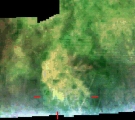
Cassini Instrument: Visual and Infrared Mapping Spectrometer (VIMS)
|
Release Date: 3 April 2009 Credit: NASA/JPL/University of Arizona Image Notes: Infrared image of Hotei Arcus, a region on Titan where changes in brightness have been measured several times and which is suspected to be a site of current activity, possibly an ice volcano. |
 |