Titan Fly-by - 22 June 2009
19 June 2009
On Monday, 22 June, the Cassini spacecraft returns to Titan for the mission's fifty-eighth targeted encounter with Saturn's largest moon: T-57. The closest approach to Titan occurs at 18:32:35 UTC, at an altitude of 955 kilometres above the moon's surface and at a speed of 6.0 kilometres per second. The latitude at closest approach is 42.2°S and the encounter occurs on orbit number 113.This encounter is set up with two manoeuvres: an apoapsis manoeuvre on 14 June, and a Titan approach manoeuvre, scheduled for 19 June. T57 is the sixth fly-by in a series of eleven inbound encounters and the thirteenth Titan encounter in Cassini's Equinox Mission. It occurs just under three days before Saturn closest approach.
Science Highlights
- Ion and Neutral Mass Spectrometer (INMS)
INMS has a prime observation at closest approach of the night side outer flank at mid Southern latitudes. - Cassini Radar (RADAR)
RADAR conducts a ridealong SAR on INMS, outbound altimetry, scatterometry, and radiometry. The SAR runs parallel to tracks from the two previous fly-bys T55 and T56 in the southern hemisphere mapping sequence. - Radio Science Subsystem (RSS)
RSS observes an ingress-only Titan ionospheric/atmospheric occultation on T57. The occultation probes a northern latitude of 78.7°, the highest in both the nominal and extended missions. The occultations will shed more light on Titan's polar vortex, and together with previous occultations, on the latitudinal variability of the electron density profile of the ionosphere, temperature/pressure profile, absorptivity profile, and small scale-structure of the neutral atmosphere. - Composite Infrared Spectrometer (CIRS)
CIRS conducts mid-southern latitude far and mid infrared vertical composition section. - Imaging Science Subsystem (ISS)
ISS will perform a 0.5-hour illuminated prime observation primarily for photometry. ISS will ride along with VIMS to observe Titan's trailing hemisphere at mid-southern latitudes and relatively low phase angle and with CIRS to monitor clouds. - Visual and Infrared Mapping Spectrometer (VIMS)
On the inbound leg, the phase angle is much larger than 90° and VIMS ridealong observations will provide information on Titan's atmospheric composition. After closest approach, VIMS will observe the South Pole region riding along with CIRS far from Titan. Only cloud monitoring will be possible. - Ultraviolet Imaging Spectrograph (UVIS)
The instrument will obtain an image cube of Titan's atmosphere at EUV and FUV wavelengths by sweeping its slit across the disk. These cubes provide spectral and spatial information on nitrogen emissions, H emission and absorption, absorption by simple hydrocarbons, and the scattering properties of haze aerosols. This is one of many such cubes gathered over the course of the mission to provide latitude and seasonal coverage of Titan's middle atmosphere and stratosphere. - Magnetospheric Imaging Instrument (MIMI)
MIMI measures energetic ion and electron energy input to Titan's atmosphere. - Dual Technique Magnetometer (MAG)
T57 is another flank-out, post-dusk fly-by, with a minimum altitude of 955 km. As in T55 and T56 MAG measurements will provide a description of the draping and the pileup of the external magnetic field around Titan on the nightside hemisphere. It will be also a good complement to T52, T53, T54, T55 and T56 in order to characterize the background field for a similar local time with respect to Saturn and different SKR longitudes. - Radio and Plasma Wave Science (RPWS)
RPWS will measure thermal plasmas in Titan's ionosphere and surrounding environment; search for lightning in Titan's atmosphere; and investigate the interaction of Titan with Saturn's magnetosphere.
Table of Events
13 June 2009
| Time UTC | Time wrt T-57 |
Activity |
| 04:41:00 | -09d 14h | Start of sequence S51 that contains Titan-57 |
19 June 2009
| Time UTC | Time wrt T-57 |
Activity |
| 11:40:00 | -03d 07h | OTM #202 prime. Titan-57 targeting manoeuvre |
20 June 2009
| Time UTC | Time wrt T-57 |
Activity |
| 11:40:00 | -02d 07h | OTM #202 backup |
22 June 2009
| Time UTC | Time wrt T-57 |
Activity |
| 04:10:00 | -14h 22m | Start of the TOST segment |
| 04:10:00 | -14h 22m | Turn cameras to Titan |
| 04:50:00 | -13h 42m | New waypoint |
| 04:50:00 | -13h 42m | Deadtime, 15 minutes and 48 seconds long. Used to accommodate changes in fly-by time |
| 05:05:48 | -13h 27m | Titan atmospheric observations - CIRS. Obtain information on CO, HCN, CH4. Integrate on disk at airmass 1.5-2.0 |
| 08:32:35 | -10h 00m | Titan surface observations - ISS. Nightside NAC. Monitoring for surface/atmosphere changes; attempt to see surface colour variations; monitor limb hazes, 1-3 km/px |
| 09:32:35 | -09h 00m | Titan atmospheric observations - UVIS. EUV/FUV imaging of Titan. Several slow scans across Titan's visible hemisphere to form spectral images |
| 15:05:35 | -03h 27m | Transition to thruster control |
| 15:06:35 | -03h 26m | Titan atmospheric observations - UVIS. EUV/FUV imaging of Titan. Several slow scans across Titan's visible hemisphere to form spectral images |
| 16:17:35 | -02h 15m | Titan atmospheric observations - CIRS. Vertical sounding of stratospheric compounds on Titan, including H2O. Integrations at 2 locations on the limb displaced vertically |
| 17:22:35 | -01h 10m | Titan atmospheric observations - RSS. RSS ingress/egress occultation of Titan's atmosphere and ionosphere |
| 18:08:41 | -00h 24m | Earth occultation, 24 minute duration |
| 18:10:16 | -00h 22m | Solar occultation, 22 minute duration |
| 18:12:47 | -00h 20m | RADAR/INMS. Ride-along SAR with INMS |
| 18:32:35 | +00h 00m | Titan-57 Fly-by Closest Approach Time. Altitude = 955 km, speed = 6.0 kms-1, 128° phase at closest approach |
| 18:45:05 | +00h 13m | RADAR. Outbound altimetry |
| 18:53:35 | +00h 21m | Descending ring plane crossing |
| 19:02:35 | +00h 30m | RADAR. Outbound HiSAR |
| 19:22:35 | +00h 50m | Transition off of thruster control |
| 19:44:16 | +01h 12m | RADAR. Outbound scatterometry |
| 20:32:35 | +02h 00m | RADAR. Outbound radiometry |
23 June 2009
| Time UTC | Time wrt T-57 |
Activity |
| 00:02:35 | +05h 30m | Titan atmospheric observations - UVIS. EUV/FUV Imaging of Titan. Several slow scans across Titan's visible hemisphere to form spectral images |
| 03:02:35 | +08h 30m | Titan surface observations-ISS. WAC Photometry. Monitoring for surface/atmosphere changes; attempt to see surface colour variations; monitor limb hazes, 1-3 km/px |
| 03:32:35 | +09h 00m | Titan surface observations - VIMS. Map of Titan |
| 08:32:35 | +14h 00m | Titan atmospheric observations - CIRS. Obtain information on the thermal structure of Titan's stratosphere |
| 16:32:35 | +22h 00m | Deadtime, 27 minutes and 24 seconds long. Used to accommodate changes in fly-by time |
| 17:00:00 | +22h 28m | Turn to Earth-line |
| 17:40:00 | +23h 08m | Playback of T57 data; Goldstone 70m ground station |
24 June 2009
| Time UTC | Time wrt T-57 |
Activity |
| 03:40:00 | +01d 09h | Playback of T57 data; Canberra 70m ground station |
Observation Results
Cassini Instrument: Cassini Radar (RADAR)
|
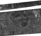
Release Date: 16 July 2009 Credit: NASA/JPL Image Notes: Radar image centred near 76.5°S, 213°W showing an area in Titan's south polar region of 190×140 km with an enigmatic 100-km wide basin. |
 |
Last Update: 1 September 2019