Mars Express Commissioning and Early Results
The Mars Express spacecraft has continued to show nominal performance over the past week with the payload and subsystems operating as expected. The spacecraft's main engine has been isolated as it will not be used anymore. The Beagle-2 lander was separated from the Mars Express orbiter on 19 December and is assumed to have landed in Isidis Planitia on 25 December. However, attempts to communicate with the lander have so far been unsuccessful.
Meanwhile, the orbiter scientific payload commissioning has started and the payload instruments started returning their first scientific measurements from Mars orbit. During this early phase, mostly dedicated to instrument checkout and calibration, high-resolution stereo and colour images and high-resolution spectral measurements of the planet are being acquired. The radio science experiment has been obtaining its first scientific data from Mars (bistatic radar measurements), and the MARSIS radar, which is scheduled for deployment at the end of April 2004, will soon be conducting further checkout activities.
The early orbits of Mars Express, until about mid-February 2004, represent the best opportunity for optimised observing conditions (illumination, targets of interest, distance to the Sun, lack of eclipses) and, therefore, maximum science return.
The planning of the next payload commissioning activities and science operations are progressing nominally. Payload activity timelines are being prepared for the next few weeks, with the goal of optimising the scientific return while keeping within the limits of the power budget.
Science Results
| 19 January 2004 | |
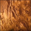
| HRSC The first science result showed the Valles Marineris canyon system in stunning detail. Valles Marineris is a giant canyon system stretching 4000 km across the surface of the planet. At its start and end it is 2 km deep and in the middle it is 7 km deep and 600 km wide. |
 |
| 23 January 2004 | |
| OMEGA Analysis of data acquired over the southern polar cap on 18 January has revealed the existence of trapped water ice along with carbon dioxide ice. |
|
| PFS PFS data has shown that there is an imbalance to the distribution of carbon dioxide on Mars. |
 |
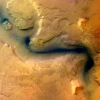
| HRSC HRSC has now imaged an area of the Martian surface covering 1.87 million km2. This corresponds to 100 Gigabytes of data! The camera images a single track up to 4000 km in length (roughly the size of the United States from coast to coast). A series of stunning images have been released revealing river channels, dust falling over a cliff edge and erosion features. |
 |
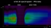
| SPICAM A unique measurement was made with SPICAM. By observing a star twice, once through the atmosphere and once with no atmosphere present, it was possible to analyse the Martian atmosphere. This has enabled measurements to be made on the distribution of the ozone and water vapour revealing that there is more water vapour where there is less ozone. | |

Orbit and Surface Coverage Information
The orbit of the Mars Express spacecraft is very stable. Several more apocentre reduction manoeuvres will be conducted in order to reach the selected mapping orbit on 28 January.
The early scientific planning is driven by the opportunity to take images and spectral measurements of a number of targets of interest under excellent observing conditions. The current observations cover a variety of essential Martian surface features and targets of interest: volcanic terrains, chaotic terrains near Valles Marineris, Isidis Planitia with the Beagle-2 landing site, and the Spirit landing site (Gusev Crater). Later on, once the mapping orbit is achieved, the focus of science data acquisition will be extended to global coverage, mosaic and map construction, and high-resolution imaging and spectral mapping of selected local surface targets.
Scientific Payload Status and Measurements
The status and performance summarised in the following table
| Instrument | Activities | Status/Performance |
| ASPERA |
Calibrations (completed) |
Nominal |
| HRSC/SRC |
Nadir-pointed stereo and colour imaging |
Nominal |
| MARSIS |
None |
Checkout next week |
| OMEGA |
Nadir-pointed hyperspectral measurements |
Nominal |
| PFS |
Nadir-pointed spectral measurements |
Nominal |
| SPICAM |
Nadir and star occultation observations |
Nominal |
During the past week a number of nadir-pointed and inertial observations were made. Stereo and colour images, multi/hyper-spectral visible and near-infrared data sets, and UV-infrared spectra were acquired and delivered by the HRSC/SRC, OMEGA, PFS and SPICAM instruments on board the orbiter. This first set of Mars Express scientific data, containing some of the highest spatial and spectral resolutions ever obtained and returned from Mars orbit, is already revealing important information about Martian surface features, in particular in the chaotic and volcanic regions, outflow channel areas, and near the crustal dichotomy boundary.
