Lunar Impact
Additional orbit trim manoeuvres took place in late July 2006 and lasted about two days. This fine tuning gave an impact time of between 05:30 - 06:30 UTC on 3 September 2006, allowing optimal observations from some of the world's largest telescopes: ESO (Chile), Kitt Peak (Arizona, US) and Hawaii.
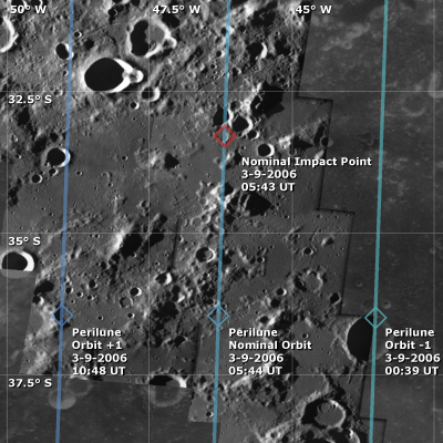
Final manoeuvres were performed during the night of 1-2 September 2006 when the perilune was boosted by nearly 600 metres to ensure the spacecraft would not impact on the fore-last orbit. The manoeuvres were successful and SMART-1 was on-course for a nominal impact at 05:42 UT on 3 September.
 |
|
AMIE image mosaic of area around the SMART-1 impact site |
Timeline of Events
| Date | Activity |
| May 2006 | Manoeuvres preparation |
| 13 June 2006 | Remove solar array 35° offset |
| Mid June 2006 | SMART-1 perilune height <300 km; platform constraints |
| 19 June 2006 | Start of perilune raising manoeuvres; payload activities stopped |
| 2 July 2006 | End of manoeuvres |
| 3 July 2006 | Resume payload operations |
| ~20 July 2006 | SMART-1 perilune height <200 km; platform and payload constraints |
| 26-28 July 2006 | Trim manoeuvres to adjust time of Moon impact |
| Mid August 2006 | SMART-1 perilune height <100 km; platform and payload constraints |
| 1 September 2006 | Last trim manoeuvre |
| 3 September 2006 | Real time Moon impact at 05:42 UT; World observatories coordination from ESOC Last observations |
Orbital Information
The interactive diagrams below show SMART-1's expected orbit evolution from 19 June to 3 September, plus details on the projected final orbit, both as of 23 August 2006. In addition details for the adjacent two orbits of the nominal impact orbit are given.
Around impact, the perilune distance reduced by 1.2 km per revolution. Clementine LIDAR (Laser Image Detection And Ranging) data are used for the Moon topography. The accuracy of this data ranges from 100 m at the measurement points to 2 km in-between the Clementine ground tracks.