Second Close Titan Flyby
14 December 2004
The second targeted flyby of Titan, Titan B, occured on Monday, 13 December 2004 at 11:38 UT. Cassini's closest approach to Saturn's largest satellite was at an altitude of 1200 km above the surface at a speed of 6.1 kilometres per second. As Titan's diameter is 5150 km, the spacecraft passed within 1.5 Titan radii.Two earlier manoeuvres led up to the event: an apoapsis manoeuvre performed on 20 November, and a Titan approach manoeuvre, performed on 9 December. Titan B was an inbound flyby, with Saturn periapsis occurring about two days afterwards, on 15 December.
Titan B was Cassini's third targeted satellite encounter. The first was Phoebe, on 11 June, at an altitude of 2000 km. The second was Titan A, on 26 October, at an altitude of 1174 km. After the second targeted encounter with Titan, Cassini will also make observations of the moon Dione when it experiences a non-targeted closest approach to the moon at a distance of 72 500 kilometres.
Science activities
The Cassini-Huygens project is interested in four broad science themes concerning Titan: its interior structure, surface characteristics, atmospheric properties, and interaction with Saturn's magnetosphere. Titan B will provide further constraints on the density of Titan's atmosphere. This will contribute significantly to atmospheric modelling necessary to validate the lower flyby altitudes for future passes (and perhaps the Huygens Probe mission profile as well). The sources of this improvement will come primarily from the UVIS atmospheric occultation data and AACS attitude control telemetry during the flyby.
- CAPS was to make measurements of Titan's upper ionosphere and gather science from Cassini's crossing through Titan's plasma wake. Both ion and electron measurements were made during the flyby. The recent trajectory shift due to Iapetus has caused Titan B to be geometrically similar to Titan A. This gave CAPS and other teams an excellent opportunity to look for time variability, as well as getting more/better data on all of their goals from Titan A.
- CIRS was to perform a 2-hour limb integration using their mid-IR detectors to search for new molecules in the stratosphere. They would also continue their campaign of far-IR integrations (begun on T0) to search for species at longer wavelengths, and obtain a thermal map of the stratosphere, lending insight into the dynamics of Titan's atmosphere
- For ISS Titan B provided opportunities for imaging at high-resolution (pixel scales as small as a few tens of a metre) and low-phase angles (as low as 16 degrees). ISS observations include the Huygens' landing site (designed to allow stereo coverage with T10) and the locations of the specular points during both Titan A and Titan B. Outbound ride-along observations with VIMS were hoped to provide views of Titan's north polar region illuminated by Saturn-shine
- MAG was to study the influence of the incident plasma flow on the highly dynamic outer magnetosphere
- MIMI was to examine Titan's exosphere with ENA imaging and characterize the ion composition and charge state near Titan
- RPWS was to measure the density and temperature of Titan's ionospheric electrons, look for evidence of ion pickup processes as part of the magnetosphere–Titan interaction, look for radio emissions from Titan, and search for lightning in Titan's ionosphere
- UVIS was to observe two stellar occultations which will tell us about the vertical profile of methane gas in Titan's high atmosphere. This will provide constraints on the density of the atmosphere. This is valuable for science and also for establishing the safety issues for low passes later in the tour.
- VIMS was to perform observations of the surface of Titan at small solar phase angles, and investigate the formation and evolution of clouds on Titan. They were also to search for lightning and hot spots and make an attempt at airglow characterization.
Table of events
09 December 2004
| Time UTC | Time wrt Titan-B |
Event |
| 22:14 | - 03d 15h | OTM #7 TB approach, targeting manoeuvre |
10 December 2004
| Time UTC | Time wrt Titan-B |
Event |
| 09:11 | - 03d 04h | ISS Titan movie: 15 images of Titan every hour for 12 hours. |
| 22:13 | - 02d 15h | 9.5 hr playback, Madrid 34m pass |
11 December 2004
| Time UTC | Time wrt Titan-B |
Event |
| 09:11 | - 02d 04h | ISS Titan movie: 15 images of Titan every hour for 15 hours |
12 December 2004
| Time UTC | Time wrt Titan-B |
Event |
| 01:08 | - 01d 12h | ISS ring observation: radial colour scan of rings |
| 05:44 | - 01d 07h | 9 hr playback to empty both SSRs; 1h 41m to Madrid 70m, then 7h 19m to Goldstone 70m |
| 16:21 | - 20h 25m | Begin low to medium resolution observations: Mid and Far IR CIRS observations and medium resolution imaging |
13 December 2004
| Time UTC | Time wrt Titan-B |
Event |
| 04:46 | - 08h 00m | Several slow scans across Titan; Spectral imaging |
| 08:46 | - 04h 00m | Begin regional map / high resolution |
| 12:16 | - 00h 30m | Transition to thrusters. Duration = 21 minutes |
| 12:37 | - 00h 09m | Turn UVIS to Alpha Vir & Lambda Sco; Atmospheric occultations until 13:36 |
| 12:46 | + 00h 00m | Titan B flyby closest approach; Altitude = 1200 km, speed = 6.1 kms-1; low phase inbound, 101° phase at closest approach, high phase outbound |
| 13:13 | + 00h 27m | Transition back to reaction wheels. Duration = 24 minutes |
| 13:36 | + 00h 50m | Dark side observations of Titan; search for and monitor lightning/aurora |
| 14:42 | +01h 56m | Ascending Ring-Plane Crossing |
| 17:46 | + 05h 00m | Titan limb observations; search for trace constituents in Titan's stratosphere |
14 December 2004
| Time UTC | Time wrt Titan-B |
Event |
| 00:00 | + 11h 14m | Begin playback of Titan B data; Madrid 70m pass; critical UVIS data first |
| 09:00 | + 20h 14m | End playback of Titan B data |
15 December 2004
| Time UTC | Time wrt Titan-B |
Event |
| 02:52 | + 01d 14h | Dione closest approach (72 500 km) (non-targeted) |
| 07:00 | + 01d 18h | Saturn periapse, at 4.8 Saturn radii, 108° phase |
| 12:12 | + 01d 23h | Descending ring-plane crossing 5.8 radii from Saturn, through centre of E ring |
Titan surface coverage
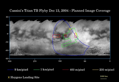
This map of Titan's surface illustrates the regions that will be imaged by the Cassini spacecraft during the spacecraft's second close flyby of Titan on 13 December 2004.
 |
|
Credit: NASA/JPL/Space Science Institute |
The coloured lines delineate the regions that will be imaged at differing resolutions. The lower-resolution imaging sequences (outlined in blue) are designed to study the atmosphere, clouds, and surface in a variety of spectral filters, and to make movies of the evolution of clouds over time scales of hours. Other areas have been specifically targeted for moderate and high resolution mosaicking of surface features. These include the site where the European Space Agency's Huygens probe is predicted to touch down in mid-January (marked with the yellow X), part of the bright region named Xanadu (easternmost extent of the coverage area), and a boundary between dark and bright regions.
This second encounter is similar in geometry to the first close Titan flyby in October, so Cassini scientists have taken advantage of this to retarget some of the same areas in order to look for changes and to cover new territory as well. This is the reason for the rather irregular shape of the green outline.
The map was made from global images taken in June 2004 at image scales of 35 to 88 kilometre per pixel and from south polar coverage from July 2004 at an image scale of 2 kilometres per pixel. The images were obtained using a narrow band filter centred at 938 nanometres - a near-infrared wavelength that can penetrate Titan's atmosphere to the surface. The images have been processed to enhance surface details.
Observation Results
For a summary of the flyby results, see the link "Successful Titan-B Flyby" on the right-hand side.
