Fifth Close Titan Flyby
14 April 2005
Titan-5 is Cassini's fifth close flyby, and sixth targeted flyby of Titan. The flyby occurs on Saturday 16 April at 19:12 UT. The closest approach will be at an altitude of 1025 km above the surface at a speed of 6.1 kms-1. Titan has a diameter of 5150 km, so the spacecraft passes within 1.4 Titan radii. The Titan-5 flyby is also the first near-polar pass - the orbiter reaches a latitude of 74 deg at closest approach.This encounter is set up with two manoeuvres: an apoapsis manoeuvre performed on 9 April, and a Titan approach manoeuvre, also successfully performed on 13 April. The flyby occurs about 2 days after Saturn periapsis on 14 April, and is therefore an outbound flyby.
Science Activities
Titan-5 represents the first Titan flyby with dedicated magnetospheric pointing for a large portion of the flyby. The combination of the low altitude of the Titan-5 flyby, along with CAPS (Cassini Plasma Spectrometer) controlling the pointing starting near closest approach, will allow CAPS to take measurements near the polar (latitude 74°) ionosphere. The high latitude of closest approach means Cassini will be flying through the Alfven currents which couple Titan to Saturn's magnetosphere. CAPS will continue to take high resolution data out to 120 Titan radii observing distant signatures of Titan's interaction with Saturn's magnetosphere.
- Composite Infrared Spectrometer (CIRS)
CIRS will attempt to detect new species in the far-infrared at high latitude (55°). It will also map CH4, CO, HCN, etc. using long wavelength rotational lines. - Ion and Neutral Mass Spectrometer (INMS)
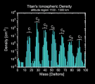
INMS will perform a critical first step in sampling the global composition of the thermosphere and ionosphere. Around closest approach, INMS will measure the minor ion and neutral densities. - Imaging Science Subsystem (ISS)
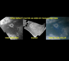
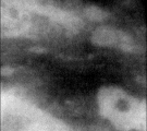
For the ISS, T5 provides a second good look (after T4) of the sub-Saturn hemisphere, including the first high-resolution (< 250 metres/pixel) coverage of the sub-Saturn region. This will be the first good look at the quasi-circular, approximately 1000 km diameter, feature, perhaps associated with an impact structure. - Dual Technique Magnetometer (MAG)
For MAG, T5 is the most important flyby among all the Titan encounters of the mission. It is close to optimum for electromagnetic studies of Titan's interior via induction effects. The flyby geometry is also well suited for the study of the origin of Alfven wings and slow mode wings. The low altitude of closest approach is very favourable for studies of an internal magnetic field with a dipole near the rotation axis. - Magnetospheric Imaging Instrument (MIMI)
MIMI will investigate detailed aspects of the Titan's interaction with Saturn's magnetosphere by observing through closest approach with a desirable spacecraft orientation. - Radio and Plasma Wave Science (RPWS)
RPWS will measure large-scale and distant aspects of Titan's interaction with Saturn's magnetosphere by observing during the entire period around closest approach and from 10 to 25 Saturn radii. - Ultraviolet Imaging Spectrograph (UVIS)
UVIS will continue spectral imaging to map Titan's atomic emissions, acetylene distribution, and haze properties. - Visual and Infrared Mapping Spectrometer (VIMS)
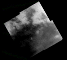
VIMS will map a portion of the northern hemisphere, study cloud formation and dissipation, and attempt to correlate composition with geological features.
Table of Events
09 April 2005
| Time UTC | Time wrt Titan-5 |
Event |
| 05:15:00 | -07d 14h | Start of Sequence S10 which contains T5 |
13 April 2005
| Time UTC | Time wrt Titan-5 |
Event |
| 20:40:00 | -02d 23h | OTM #22 Prime; T5 minus 3 day targeting manoeuvre |
15 April 2005
| Time UTC | Time wrt Titan-5 |
Event |
| 02:14:00 | -01d 17h | OTM #22 Backup |
16 April 2005
| Time UTC | Time wrt Titan-5 |
Event |
| 06:25:00 | -12h 46m | Turn cameras to Titan |
| 06:55:00 | -12h 16m | Deadtime, used to accommodate changes in flyby time |
| 06:17:46 | -11h 54m | Infrared stare at high latitude, attempt to detect new molecular species |
| 10:41:46 | -08h 30m | Titan atmospheric & surface observations. Multi-filter, wide- and narrow-angle-camera images of Titan's atmosphere and surface |
| 11:11:46 | -08h 00m | Spectral imaging of visible hemisphere, several slow scans across Titan |
| 16:11:46 | -03h 00m | High resolution surface imaging by ISS & VIMS. Twelve ISS NAC footprints (some along the T3 SAR swath) with pixel scales 725-250 m |
| 18:11:46 | -01h 00m | Transition to thrusters |
| 18:32:46 | -00h 39m | Turn to MAPS attitude. Studies of Titan's interaction with Saturn's magnetosphere |
| 18:52:46 | -00h 19m | INMS attitude through closest approach. Composition sampling of thermosphere and ionosphere |
| 19:11:46 | +00h 00m | T5 flyby closest approach. Altitude=1025 km, velocity=6.1 kms-1, 126° phase |
| 19:23:46 | +00h 12m | Return to MAPS attitude for next 16 hours. High resolution measurements of Titan's interaction with Saturn's magnetosphere. This activity continues through closest approach and out beyond 120 Titan radii. |
| 19:48:46 | +00h 37m | Transition to Reaction Wheels. Duration = 24 minutes |
| 19:51:00 | +00h 40m | Descending ring plane crossing |
17 April 2005
| Time UTC | Time wrt Titan-5 |
Event |
| 11:48:47 | +16h 37m | Deadtime, used to accommodate changes in flyby time |
| 11:59:00 | +16h 48m | Turn to Earth-Line |
| 12:31:00 | +17h 20m | Begin playback of T5 data to Madrid 70M |
| 21:25:00 | +01d 02h | End playback of T5 data |
23 April 2005
| Time UTC | Time wrt Titan-5 |
Event |
| 23:10:00 | +07d 04h | Saturn apoapse 007, r=40.6 RS, phase=65° |
Times last updated on 11 April 2005 - subject to change.
The time is in UT of the event. After this it takes about 1 hour and 8 minutes for the signal to reach Earth.
Titan Surface Coverage
 |
|
Credit: NASA/JPL/Space Science Institute |
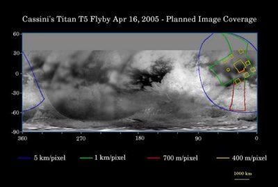
This map of Titan's surface illustrates the regions that will be imaged by Cassini during the spacecraft's close flyby of the smog-enshrouded moon on 16 April 2005. At closest approach, the spacecraft is expected to pass approximately 1025 kilometres above the moon's surface. The coloured lines delineate the regions that will be imaged at differing resolutions.
Images from this encounter will add to those taken during the 31 March 2005 flyby and improve the moderate resolution coverage of this region. The imaging coverage will include the eastern portion of territory observed by Cassini's radar instrument in October 2004 and February 2005, and will provide a way to compare the surface as viewed by the different instruments. Such comparisons will provide insight into the nature of Titan's surface.
The higher-resolution (yellow boxes) have been spread out around a central mosaic in order to maximize coverage of this region by the visual and infrared mapping spectrometer which will be observing simultaneously with the cameras of the imaging science subsystem.
The map shows only brightness variations on Titan's surface (the illumination is such that there are no shadows and no shading due to topographic variations). Previous observations indicate that, due to Titan's thick, hazy atmosphere, the sizes of surface features that can be resolved are a few times larger than the actual pixel scale labelled on the map.
The images for this global map were obtained using a narrow band filter centred at 938 nanometres in the near-infrared. At this wavelength, light can penetrate Titan's atmosphere to reach the surface and return through the atmosphere to be detected by the camera. The images have been processed to enhance surface details.
It is currently northern winter on Titan, so the moon's high northern latitudes are not illuminated, resulting in the lack of coverage north of 35 degrees north latitude.
Observation Results
Cassini Instrument: Visual and Infrared Mapping Spectrometer (VIMS)
Cassini Instrument: Ion and Neutral Mass Spectrometer (INMS)
Cassini Instrument: Imaging Science Subsytem (ISS)

