Cassini to View Huygens Landing Site
27 October 2005
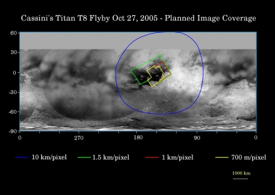
The Cassini spacecraft will make another flyby of Titan on 28 October allowing it to image the Huygens landing site.The map below shows Titan's surface and illustrates the regions that will be viewed by Cassini's imaging cameras during the spacecraft's close flyby. At closest approach, the spacecraft is expected to pass approximately 1400 kilometers above the moon's surface.
 |
|
Credit: NASA/JPL/Space Science Institute |
The coloured lines delineate the regions that will be imaged at differing resolutions.
The highest resolution imaging coverage during the flyby will be of the eastern portion of the dark region called Shangri-la and the boundary between Shangri-la and bright Xanadu. Several of the major "islands" in eastern Shangri-la will be featured, including faculae (or bright spots) which have the provisional names Kerguelen, Vis, Crete and Tortola. These bright features on Titan are named for island features from Earth.
The map shows only brightness variations on Titan's surface (the illumination is such that there are no shadows and no shading due to topographic variations). Previous observations indicate that, due to Titan's thick, hazy atmosphere, the sizes of surface features that can be resolved are a few to five times larger than the actual pixel scale labelled on the map.
The images for this global map were obtained using a narrow band filter centered at 938 nanometres - a near-infrared wavelength at which light can penetrate Titan's atmosphere to reach the surface and return through the atmosphere to be detected by the camera. The images have been processed to enhance surface details.
Science Activities
The instruments on Cassini will perform the following activities during the flyby:
- RADAR will perform SAR imaging of the dark terrain west of Xanadu. This area includes the Huygens landing site.
- The Ion and Neutral Mass Spectrometer (INMS) will obtain data regarding atmospheric and ionospheric composition and thermal structure.
- The Magnetospheric and Plasma Science (MAPS) teams, in general, will continue observations of Titan's interaction with Saturn's magnetosphere – including the period within one hour of Titan closest approach.
- The Radio and Plasma Wave Spectrometer (RPWS) will look for lightning and other radio emissions, perform a characterization of the plasma wave spectrum, and search for evidence of pickup ions.
- The Composite Infrared Spectrometer (CIRS) will obtain vertical profiles of temperatures, HCN, and C2H2 in Titan's tropopause, stratosphere, and on the surface. CIRS will also obtain information on trace constituents in the stratosphere.
- The Imaging Science Subsystem (ISS) will monitor Titan for surface and atmospheric changes, including cloud motion. Some high-resolution imaging also will occur.
