Rhea Flyby - November 2005
20 November 2005
November of 2005 includes the final flyby of an amazing string of close icy satellite encounters. As September included the closest-ever encounters with Tethys and Hyperion, October contained the single targeted encounter at Dione. November brings the only targeted encounter at Rhea.The closest approach to Rhea occurs on Saturday, 26 November, at 22:37 UTC at an altitude of 500 km above the surface and at a speed of 7.3 kilometres per second. Rhea has a diameter of 1528 km, making it the largest icy satellite. Rhea is spherical in shape. The next-closest encounter with Rhea occurs in 2007 on orbit 49, at a distance of 5000 km.
This encounter is set up with two manoeuvres: an apoapsis manoeuvre scheduled for 13 November, and an approach manoeuvre, scheduled for 23 November. The encounter itself occurs approximately 12 hours prior to periapsis to Saturn. The cleanup manoeuvre for the flyby occurs just a day after the encounter.
Occurring on orbit 18, Rhea will be the eighth close encounter with icy satellites, after Phoebe, Enceladus (orbit 3, non-targeted), Enceladus (orbit 4), Enceladus again (orbit 11), Tethys (orbit 15, non-targeted), Hyperion (also orbit 15) and Dione (orbit 16). It could be argued that the study of Iapetus on orbit C was intense enough even at 120 000 km to merit inclusion in this list, which would mak this encounter the ninth.
Science Activities
The 26 November 2005 flyby of Rhea represents the closest encounter to Rhea during the Cassini mission. The focus of the flyby is Radio Science measurements of the mass of Rhea. The flyby geometry is oriented such that Rhea's wispy terrain on the trailing and anti-Saturnian hemispheres is easily observable by the remote-sensing instruments on Cassini. The primary science investigations will be centred around the following questions:
- What is the interior structure of Rhea?
- What is the compositional makeup of Rhea, other than water ice?
- Did resurfacing occur early in Rhea's history?
- What do the cracks and fractures tell us about the recent geologic history of Rhea?
- How does Rhea interact with Saturn's E-ring and magnetosphere?
- Cassini Plasma Spectrometer (CAPS)
CAPS will make measurements of the plasma environment around Rhea to understand its effects, if any, on the surrounding Saturn magnetosphere. This flyby will provide a downstream crossing of the wake region of Rhea, the first icy satellite wake crossing of the tour. The geometry is complementary for CAPS to the 2007 Rev 49 encounter with Rhea. - Composite Infrared Spectrometer (CIRS)
CIRS will perform scans of the disk of Rhea to measure daytime and nighttime temperatures. These measurements will constrain the bolometric albedo, the thermal inertial and volatile stability of the surface. - Imaging Science Subsystem (ISS)
For ISS, this Rhea flyby provides an opportunity to capture the best images of the wispy terrain and to obtain high-resolution images of a relatively fresh, bright crater on the leading hemisphere. ISS will perform mosaics on the inbound leg (178 000 – 54 000 km) for regional mapping. At closest-approach, ISS will capture the highest-ever resolution images of Rhea as the moon passes through the field-of-view of the camera. - Cassini Radar (RADAR)
Radar measurements of Rhea, both scatterometry and radiometry will be used to will constrain the bulk density and/or the relative ice cleanliness in the upper layer of regolith. - Radio and Plasma Wave Science (RPWS)
RPWS will look for evidence of a plasma source at Rhea. The RPWS data will be used to examine the plasma wave spectrum for evidence of magnetosphere-moon interactions. RPWS measurements will also be used to look for the signature of dust impacts. - Radio Science Subsystem (RSS)
RSS will make measurements of Rhea's mass during four blocks of time dedicated to this study, including the time right around closest-approach. The measurements will help to constrain Rhea's internal structure and gravity field. - Ultraviolet Imaging Spectrograph (UVIS)
UVIS will observe Rhea to look for evidence of a tenuous, sputter-produced atmosphere. UVIS will also map the surface to look for brightness variations at far-UV wavelengths, indicative of compositional variations and/or grain size variations. - Visible and Infrared Mapping Spectrometer (VIMS)
Measurements by VIMS will investigate surface composition. VIMS will identify minerals and other non-water ice species in the surface of Rhea. VIMS measurements will also be used to understand grain size variations across the surface.
Table of Events
12 November
| Time UTC | Time wrt Rhea-1 |
Event |
| 17:01 | - 14d 06h | Start of Sequence S16 which contains Rhea-1 |
23 November
| Time UTC | Time wrt Rhea-1 |
Event |
| 07:03 | - 03d 16h | OTM #43 Prime, Rhea-1 approach targeting manoeuvre |
24 November
| Time UTC | Time wrt Rhea-1 |
Event |
| 07:03 | - 02d 16h | OTM #43 Backup |
25 November
| Time UTC | Time wrt Rhea-1 |
Event |
| 15:48 | - 01d 07h | Start of the SOST Segment |
| 15:48 | - 01d 07h | Turn cameras to Saturn |
| 17:25 | - 01d 05h | Saturn observation CIRS compositional map |
26 November
| Time UTC | Time wrt Rhea-1 |
Event |
| 04:25 | - 18h 12m | Turn cameras to Rhea |
| 04:45 | - 17h 52m | Deadtime 17.5 minutes long; used to accommodate changes in flyby time |
| 05:02 | - 17h 35m | Inbound Rhea ORS observations (distant) Images, compositional and temperature maps between 540 540 km and 427 915 km |
| 08:11 | - 14h 26m | Turn to Earth |
| 08:32 | - 14h 05m | Radio Science Rhea Mass determination; 2 hr downlink - Goldstone 34m |
| 11:50 | - 10h 47m | Turn to Rhea |
| 12:11 | - 10h 26m | ORS observations (low-resolution), compositional information and maps from 290 000 km |
| 12:33 | - 10h 04m | Turn to Earth |
| 12:54 | - 09h 43m | Radio Science Rhea Mass determination; 2.75 hr downlink - Goldstone 34m |
| 15:42 | - 06h 55m | Turn to Rhea |
| 16:03 | - 06h 34m | Medium- to high-resolution ORS observations, compositional information and maps between 178 165 km and 54 000 km |
| 20:33 | - 02h 04m | Turn to Earth |
| 20:58 | - 01h 39m | Radio Science Rhea Mass determination, 3 hr downlink - Canberra and Goldstone 34M, Rhea passes through ORS boresights near C/A for highest-resolution images |
| 22:38 | + 00h 00m | Rhea-1 Flyby Closest Approach Time, altitude=500 km, speed=7.3 km s-1; low phase inbound, 86.3° phase at closest approach, high phase outbound |
27 November
| Time UTC | Time wrt Rhea-1 |
Event |
| 00:31 | + 01h 54m | Turn to Rhea |
| 00:53 | + 02h 16m | Outbound (nightside) Rhea ORS, Compositional information and maps between 58 800 km and 104 175 km |
| 02:33 | + 03h 56m | Turn high-gain antenna to Rhea; RADAR scatterometry and radiometry of Rhea |
| 05:33 | + 06h 56m | Turn to Earth |
| 05:41 | + 07h 04m | Radio Science Rhea Mass determination; 2 hr downlink - Madrid 70m |
| 07:38 | + 09h 01m | Deadtime 13.5 minutes long; used to accommodate changes in flyby time |
| 08:12 | + 09h 35m | Turn to Enceladus |
| 08:37 | + 10h 00m | ORS observations, 13.5 hours of observations of Saturn and Enceladus |
| 21:55 | + 23h 18m | Turn to Earth |
| 22:15 | + 23h 38m | Playback of Rhea data; OTM #44 Prime; 9 hr downlink - Madrid 70M |
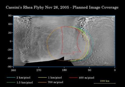
Rhea Surface Coverage
 |
|
Image: NASA/JPL/Space Science Institute |
This map of the surface of Saturn's moon, Rhea, illustrates the regions that will be imaged by Cassini during the spacecraft's close flyby of the moon on 26 November 2005. At closest approach, the spacecraft is expected to pass approximately 500 kilometres above the moon's surface.
The coloured lines delineate the regions that will be imaged at differing resolutions, listed in the legend at bottom. Rhea is 1528 kilometres across.
The new high-resolution coverage will examine details on the anti-Saturn hemisphere of Rhea, including two large impact basins there. Cassini previously imaged terrain farther to the south of this at approximately 1 kilometre per pixel in August 2005. Imaging scientists also hope to get a high-resolution view of a relatively young 50-kilometre-wide crater on the moon's leading hemisphere.
Planetary scientists are interested in learning about the compositional makeup of Rhea, other than water ice, as well as the nature of the wispy streaks on the moon's trailing hemisphere. In December, 2004, Cassini revealed that similar bright, wispy markings on Dione are actually a system of braided tectonic fractures. The map was made from images obtained by both the Cassini and NASA Voyager spacecraft.
