Seventh Close Titan Flyby
6 September 2005
Titan-7 is the eighth targeted encounter of Saturn's largest moon. The flyby occurs on Wednesday 7 September at 08:12 UTC. The closest approach will be at an altitude of 1075 km above the surface at a speed of 5.9 km s-1. Titan has a diameter of 5150 km, so the spacecraft passes just a Titan radii. The phase on approach is approximately 50°, reaching 85° at closest approach, and is approximately 128° outbound. The lower phase angles are good for the Cassini cameras.The encounter is set up with two approach manoeuvres: an apoapsis manoeuvre (OTM#30) on 30 August and another Titan targeting manoeuvre (OTM #31) on 3 September, four days before the encounter. This Titan flyby encounter is an outbound flyby, with Saturn periapsis occurring almost two days earlier. The observations will be done using thrusters for attitude control as the flyby altitude is close enough for Titan's atmosphere to have an effect. The local time at the closest approach will be near dawn.
Science Activities
There will be 3577 Mbits of data sent back to Earth. The science activities during the flyby are:
- The first RADAR SAR at high southern latitudes, where the Cassini cameras have seen some indications of lakes. This flyby will increase the SAR coverage by 50% over what we have so far. The T7 altimetry covers a very nice bright-dark-bright boundary at 235W, 20S.
- RADAR radiometry which measures the thermophysical properties of the surface, will cover northern anti-Saturn hemisphere.
- UVIS has its second stellar occultation looking for temperature of the high atmosphere and vertical profiles of N, N2 and hydrocarbons at many latitudes. This is an occulation of the star Alpha Pegasus. Species found in the Titan-B occulation include methane, acetylene, ethylene, ethane, diacetylene, and hydrogen cyanide. Cassini camera will target the 80-km diameter crater and fractures near the tip of the "H", a prominent albedo feature between 0° and 90° west longitude.
- Expand temporal coverage for atmospheric changes (haze, clouds) and detecting change on surface.
- Examine the seasonal variation of hydrocarbon and nitrile species.
- Continue the long-term campaign of temperature mapping, increasing spatial and temporal coverage. Vertical profiles of weak atmospheric species, vertical temperature map, and search for new species in the far-infrared. Mid & farinfrared measurements to obtain information on the thermal structure of titan's stratosphere.
- Further detailed studies of Titan's interaction with Saturn's magnetosphere.
- Measurements of titan's upper ionosphere and Cassini's crossing through Titan's plasma wake – ion and electron measurements.
- Study of the influence of the indident plasma flow on the highly dynamic outer magnetosphere.
- Examination of Titan's exosphere with energetic neutral atom imaging.
- Characterization of the ion compostition and charge state near Titan.
- Density and temperature measurements of Titan's ionspheric electrons - as well as a search for lightning.
Table of Events
30 Augustus 2005
| Time UTC | Time wrt Titan-7 |
Event |
| 21:43:00 | - 07d 10h | Start of Sequence S14 which contains Titan-7 |
3 September 2005
| Time UTC | Time wrt Titan-7 |
Event |
| 11:30:00 | - 03d 21h | OTM #31 Prime; Titan-7 minus 3 day targeting manoeuvre |
4 September 2005
| Time UTC | Time wrt Titan-7 |
Event |
| 10:30:00 | - 02d 22h | OTM #31 Backup |
5 September 2005
| Time UTC | Time wrt Titan-7 |
Event |
| 11:50:34 | - 01d 20h | Saturn Periapsis; Saturn periapse 014, r=2.9 Rs, phase = 105° |
6 September 2005
| Time UTC | Time wrt Titan-7 |
Event |
| 20:30:00 | - 11h 42m | Start of the TOST Segment |
| 20:30:00 | - 11h 42m | Turn cameras to Titan |
| 21:41:57 | - 10h 31m | Begin long scan across Titan; examine thermal structure of Titan's stratosphere |
| 23:26:57 | - 08h 46m | Titan atmospheric observations; monitoring for surface/atmospheric changes |
7 September 2005
| Time UTC | Time wrt Titan-7 |
Event |
| 03:11:57 | - 05h 01m | Titan limb observations; examine trace constituents in Titan's stratosphere |
| 07:20:07 | - 00h 52m | Transition to thrusters; duration = 21 minutes |
| 07:40:57 | - 00h 32m | Turn High-gain Antenna to Titan; preparation for RADAR observations |
| 07:48:57 | - 00h 24m | RADAR altimetry, inbound |
| 07:56:57 | - 00h 16m | Low Resolution Synthetic Aperture RADAR |
| 08:05:27 | - 00h 07m | High Resolution Synthetic Aperture RADAR |
| 08:11:58 | + 00h 00m | Titan-7 Flyby Closest Approach Time |
| 08:18:27 | + 00h 06m | Low Resolution Synthetic Aperture RADAR |
| 08:26:57 | + 00h 14m | RADAR altimetry, outbound |
| 08:50:57 | + 00h 38m | UVIS stellar occultation of Alpha Pegasus; examine stellar strength and spectra as it passes behind Titan's atmosphere |
| 09:35:57 | + 01h 23m | Transition to reaction wheels; duration = 24 minutes |
| 09:59:57 | + 01h 47m | RADAR radiometry, outbound |
| 13:31:57 | + 05h 19m | Turn cameras to Titan |
| 13:51:57 | + 05h 39m | Titan limb observations; examine trace constituents of Titan's stratosphere |
| 17:11:57 | + 08h 59m | Titan photometry; examine particle properties, vertical distributions |
| 20:11:57 | + 11h 59m | Begin long scan across Titan; examine thermal structure of Titan's stratosphere |
8 September 2005
| Time UTC | Time wrt Titan-7 |
Event |
| 02:24:00 | + 18h 12m | Turn to Earth-Line |
| 02:50:00 | + 18h 38m | Begin first playback of T7 data; Madrid 34-metre antenna, approximately 1/3 of data returned |
9 September 2005
| Time UTC | Time wrt Titan-7 |
Event |
| 11:09:00 | + 02d 03h | Begin second playback of T7 data; Goldstone 70-metre antenna, the remaining 2/3 of the Titan data returned |
14 September 2005
| Time UTC | Time wrt Titan-7 |
Event |
| 16:49:43 | + 07d 09h | Saturn apoapsis |
Titan Surface Coverage
 |
|
Image: NASA/JPL/Space Science Institute |
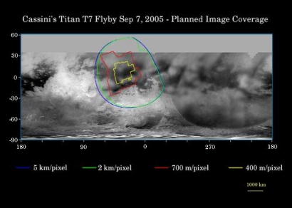
This map of Titan's surface illustrates the regions that will be imaged by Cassini during the spacecraft's close flyby of Titan on 7 September 2005. At closest approach, the spacecraft is expected to pass approximately 1075 kilometres above the moon's surface. This is Cassini's eighth flyby of Titan out of 45 flybys planned in the four-year tour.
The coloured lines delineate the regions that will be imaged at differing resolutions.
Zooming-in closer to Titan than during its previous pass two weeks earlier, Cassini camera coverage again focuses on the region known informally as "the H". Some of the narrow-angle camera images Cassini takes during this close flyby will be composited into high-resolution mosaics.
This encounter also should provide an excellent view of Bazaruto Facula and its central 80-kilometre-wide crater.
The map shows only brightness variations on Titan's surface (the illumination is such that there are no shadows and no shading due to topographic variations). Previous observations indicate that due to Titan's thick, hazy atmosphere, the sizes of surface features that can be resolved are a few to five times larger than the actual pixel scale labelled on the map.
The images for this global map were obtained using a narrow band filter centred at 938 nanometres - a near-infrared wavelength (invisible to the human eye) at which light can penetrate Titan's atmosphere to reach the surface and return through the atmosphere to be detected by the camera. The images have been processed to enhance surface details.
The Cassini-Huygens mission is a cooperative project of NASA, the European Space Agency and the Italian Space Agency.
Observation Results
Cassini Instrument: Synthetic Aperture Radar (SAR)
|
Date: 16 September 2005 Credit: NASA/JPL Image Notes: Radar-bright terrain, cut by channels of variable width, that form both radial and branching networks, reminiscent of networks formed by rainfall on Earth. |
 |
|
Date: 16 September 2005 Credit: NASA/JPL/University of Arizona Image Notes: Fluids have flowed and cut deeply-incised channels into the icy surface of Titan. The channels are roughly 1 km across and perhaps 200 metres deep. Image centred at 55° S, 7.5° W. |
 |
|
Date: 16 September 2005 Credit: NASA/JPL Image Notes: Radar-bright, rough region on the left is topographically high terrain, cut by channels and bays, bordering with a radar-dark smooth area. Scene is 175 km x 330 km, centred at 66° S, 356° W. |
 |
Cassini Instrument: Imaging Science Subsystem (ISS)
|
Date: 13 September 2005 Credit: NASA/JPL/Space Science Institute Image Notes: Mosaic of narrow-angle camera images showing more than half of Titan's Saturn-facing hemisphere including the Fensal-Aztlan region (formerly "the H"). |
 |
|
Date: 13 September 2005 Credit: NASA/JPL/Space Science Institute Image Notes: Mosaic of narrow-angle-camera infrared (938 nm) images, showing close-up of the Fensal-Aztlan region. Image is centred at 21° W, 7° N. |
 |
