Titan Flyby - 12 May 2007
10 May 2007
Sixteen days after Cassini's Titan-29 flyby, the spacecraft returns to Titan for its thirty-first targeted encounter. The closest approach to Titan occurs on Saturday, 12 May 2007, at 20:09:58 UT at an altitude of 960 kilometres above the surface and at a speed of 6.2 kilometres per second. The latitude at closest approach is 68.9° N and the encounter occurs on orbit number 44.This encounter is set up with two manoeuvres: an apoapsis manoeuvre on 4 May, and a Titan approach manoeuvre, scheduled for 8 May. This is the sixth in a series of outbound Titan encounters (first: T25, 22 February 2007; last: T33, 29 June 2007). The flyby occurs about two days after Saturn closest approach.
Science Highlights
Cassini completes its exploration of the Fensal/Aaru region on Titan with its highest resolution pass of the area.
- Cassini Radar (RADAR)
RADAR has a large number of observations during the T30 flyby. High resolution observations will help nail down the shape of smaller scale topographic features. As with other recent flybys, overlapping coverage from previous flybys will make some stereo views possible. The team's ideas of what they most want to observe are changing as more data come in. For instance, the T30 SAR observation was changed after the RADAR team looked at observations from earlier Titan flybys - Imaging Science Subsystem (ISS)
ISS will obtain a global map with resolution of 1 km/pixel, and will perform monitoring of the disk at 1.5 km/pixel at low solar phase angles. As in the previous Titan encounter, the ISS team will be monitoring for changes in the surface and atmosphere. Scientists will attempt to see if there are any surface colour variations and will monitor limb hazes at a resolution of 1-3 km/pixel. ISS will also be examining the vertical distributions of particles - Visual and Infrared Mapping Spectrometer (VIMS)
VIMS will obtain a regional map on the outbound leg of the flyby - Composite Infrared Spectrometer (CIRS)
CIRS will obtain a surface temperature map of a region in Titan's southern hemisphere, and will do limb mapping for hydrocarbons. Observations will yield information on surface and tropopause temperatures, and on the prevalence of tropospheric CH4. On the outbound leg of the encounter, CIRS will be looking for information on the thermal structure of Titan's stratosphere. CIRS will obtain information on the distribution of CO, HCN, and CH4 - Dual Technique Magnetometer (MAG)
The MAG team considers this Titan encounter one of the most interesting Titan flybys for their instrument. Like T28 and T29, T30 has a very close encounter with the northern polar flyby feature from the inner flank towards the upstream region. Near the dawn side, the magnetic field is no longer vertical or dipolar. Rather, it's equatorial, pointing towards Saturn, which indicates that the spacecraft is located below a disk of plasma of unknown structure. MAG scientists will use these observations of the magnetic field to detect the plasma disk. MAG might also have a good chance of looking at a lobe of induced magnetosphere of Titan. The solar wind might be strong enough to push the magnetopause in the direction of Saturn, causing the Titan flyby to occur in the solar wind, something Cassini hasn't yet observed. This means there might be the interesting possibility of encountering the solar wind in an unpredictable way
Table of Events
4 may 2007
| Time UTC | Time wrt Titan-30 |
Activity |
| 22:00:00 | -07d 22h | Start of sequence S30 which contains Titan-30 |
8 May 2007
| Time UTC | Time wrt Titan-30 |
Activity |
| 20:14:00 | -03d 24h | OTM #109 prime Titan-30 targeting manoeuvre |
9 may 2007
| Time UTC | Time wrt Titan-30 |
Activity |
| 20:14:00 | -02d 24h | OTM #109 backup |
10 May 2007
| Time UTC | Time wrt Titan-30 |
Activity |
| 19:31:52 | -02d 01h | Descending ring plane crossing |
| 22:46:55 | -01d 21h | Saturn periapse, R = 4.3 RS, lat = -24°, phase = 114° |
12 May 2007
| Time UTC | Time wrt Titan-30 |
Activity |
| 04:59:00 | -15h 10m | Start of the TOST segment |
| 04:59:00 | -15h 10m | Turn cameras to Titan |
| 05:29:00 | -14h 40m | Deadtime, 16 minutes and 58 seconds long. Used to accommodate changes in flyby time |
| 05:45:58 | -14h 24m | Titan atmospheric observations. Obtain information on the thermal structure of Titan's stratosphere |
| 07:09:58 | -13h 00m | Titan atmospheric observations. Cloud map |
| 11:09:58 | -09h 00m | Titan atmospheric observations. Spectral images of hemisphere |
| 15:19:58 | -04h 50m | New waypoint |
| 15:19:58 | -04h 50m | RADAR observations. Radiometry observations |
| 18:54:58 | -01h 15m | RADAR observations. Mid latitude scatterometry |
| 19:17:58 | -00h 52m | Transition to thruster control |
| 19:39:58 | -00h 30m | RADAR observations. Altimetry measurements |
| 19:42:13 | -00h 27m | Solar Occultation. 22 minute duration |
| 19:43:42 | -00h 26m | Earth Occultation. 26 minute duration |
| 19:53:58 | -00h 16m | RADAR observations. Low resolution SAR imaging |
| 20:02:58 | -00h 07m | RADAR observations. High resolution SAR imaging |
| 20:09:58 | +00h 00m | Titan-30 Flyby Closest Approach Time. Altitude = 960 km, speed = 6.2 kms-1, 122° phase at closest approach |
| 20:10:59 | +00h 01m | Ascending ring plane crossing |
| 20:16:58 | +00h 07m | RADAR observations. Low resolution SAR imaging |
| 20:25:58 | +00h 16m | RADAR observations. Altimetry measurements |
| 20:39:58 | +00h 30m | Transition off of thruster control |
| 21:03:58 | +00h 54m | RADAR observations. Mid latitude scatterometry |
| 21:26:58 | +01h 17m | RADAR observations. Radiometry observations |
13 may 2007
| Time UTC | Time wrt Titan-30 |
Activity |
| 01:04:58 | +04h 55m | New waypoint |
| 01:04:58 | +04h 55m | ISS imaging. Global map |
| 04:45:58 | +08h 36m | ISS imaging. Wide angle camera photometry examining particle properties and vertical distributions |
| 05:09:58 | +09h 00m | Titan atmospheric observations. Obtain information on CO, HCN, CH4 |
| 07:09:58 | +11h 00m | ISS imaging. Monitoring for surface/atmosphere changes; attempt to see surface colour variations; monitor limb hazes |
| 09:09:58 | +13h 00m | Titan global map |
| 10:09:58 | +14h 00m | Titan atmospheric observations. Obtain information on the thermal structure of Titan's stratosphere |
| 11:28:58 | +15h 19m | Deadtime, 14 minutes and two seconds long. Used to accommodate changes in flyby time |
| 11:43:00 | +15h 34m | Turn to Earth-line |
| 12:13:00 | +16h 04m | Playback of T30 data, Madrid 70M |
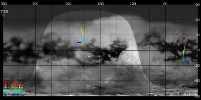
Titan Ground Trace
 |
|
Image courtesy NASA/JPL/Space Science Institute |
The above image shows the ground trace of the Titan-30 flyby on a mosaic of Titan's surface, for a period of 32 hours around closest approach. The colour of the trace indicates Cassini's altitude above the surface. Blue: > 100 000 km, green: < 100 000 km, light blue: < 50 000, yellow: < 10 000 km, orange: < 5000 km, red: < 2000 km. The point of closest approach is marked T30. Cassini approaches Titan over the southern hemisphere, near latitude -20° (lower right in this image) at 16 hours before closest approach, and then continues to pass over Titan's northern hemisphere.
Observation Results
Cassini Instrument: Imaging Science Subsystem (ISS)
|
Date: 27 June 2007 Credit: NASA/JPL/Space Science Institute Image Notes: View of northwestern part of the large, equatorial dark region known as Shangri-la, created from images taken at 938 and 619 nm |
 |
|
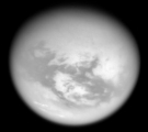
Date: 22 June 2007 Credit: NASA/JPL/Space Science Institute Image Notes: Combined view of narrow angle camera images at 938 and 619 nm, revealing bright and dark terrain on the moon's trailing hemisphere |
 |
|
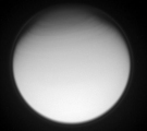
Date: 20 June 2007 Credit: NASA/JPL/Space Science Institute Image Notes: Combined view of images at 939 and 742 nm, revealing bright clouds on Titan's trailing hemisphere, as seen from 104 000 km out |
 |
|
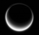
Date: 18 June 2007 Credit: NASA/JPL/Space Science Institute Image Notes: Wide angle camera view at visible wavelengths of a back-lit Titan, taken from ~305 000 km away. The detached haze layer is faintly visible |
 |
|
Date: 1 June 2007 Credit: NASA/JPL/Space Science Institute Image Notes: Narrow-angle camera ultraviolet image, showing bands of clouds in Titan's fast rotating stratosphere at high northern latitudes |
 |
Cassini Instrument: Cassini Radar (RADAR)
|
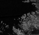
Date: 13 August 2007 Credit: NASA/JPL Image Notes: Radar swath ~2700 km long over Titan's northern hemisphere obtained on 12 May 2007. (Below image is detail of this large strip) |
 |
|
Date: 23 May 2007 Credit: NASA/JPL Image Notes: Radar image, showing a radar-dark (and thus smooth) liquid surface, surrounded by a coast line with channels and bays and numerous islands. |
 |
