Titan Flyby - 28 May 2007
25 May 2007
Sixteen days after Cassini's Titan-30 flyby, the spacecraft revisits Titan for its thirty-second targeted encounter: Titan-31. The closest approach to the Saturnian moon occures on Monday, 28 May, at 18:51:56 UTC at an altitude of 2300 kilometres above the surface and at a speed of 6.1 kilometres per second. The latitude at closest approach is 76.7° N and the encounter occurs on orbit number 45.This encounter is set up with two manoeuvres: an apoapsis manoeuvre on 20 May, and a Titan approach manoeuvre, scheduled for 25 May. This is the seventh in a series of outbound Titan encounters (first: T25, 22 February 2007; last: T33, 29 June 2007). The flyby occurs just under two days after Saturn closest approach.
Science Highlights
- Radio Science Subsystem (RSS)
The geometry of this flyby allows for occultation observations of Titan's atmosphere to be preformed. RSS will use the time surrounding and including closest approach for this. During ingress, RSS will observe the atmosphere. During egress, RSS will observe both the atmosphere and the ionosphere. This is the slowest occultation event for the entire tour. The occultation observation itself is made by DSN observations of the spacecraft signal as it passes through Titan's atmosphere. Refraction by the Titan's atmosphere produces a Doppler shift in the received frequency. This allows the retrieval of very high resolution vertical profiles of electron density in the ionosphere, and of density, pressure, and temperature in the neutral atmosphere - Imaging Science Subsystem (ISS)
ISS will obtain regional scale mapping of the bright surface feature Dilmun and global-scale mapping of Dilmun, Shangri-La, and Adiri and the (as yet unnamed) terrain to its north - Visual and Infrared Mapping Spectrometer (VIMS)
VIMS will obtain the first medium resolution maps of the trailing hemisphere. The observations will focus on the northern hemisphere. VIMS will also be seeking northern latitude clouds - Composite Infrared Spectrometer (CIRS)
CIRS will obtain information on the distribution of CO, HCN, and CH4, as well as the thermal structure of Titan's stratosphere - Ultraviolet Imaging Spectrograph (UVIS)
UVIS will perform slow scans across Titan's visible hemisphere to form spectral images
Table of Events
4 May 2007
| Time UTC | Time wrt Titan-31 |
Activity |
| 22:00:00 | -23d 21h | Start of sequence S30 which contains Titan-31 |
25 May 2007
| Time UTC | Time wrt Titan-31 |
Activity |
| 19:12:00 | -02d 24h | OTM #112 prime, Titan-31 targeting manoeuvre |
26 May 2007
| Time UTC | Time wrt Titan-31 |
Activity |
| 09:57:00 | -02d 09h | OTM #112 backup |
| 22:41:30 | -01d 20h | Descending ring plane crossing |
27 May 2007
| Time UTC | Time wrt Titan-31 |
Activity |
| 00:28:44 | -01d 18h | Saturn periapse, R = 3.2 RS, lat = -15°, phase = 119° |
28 May 2007
| Time UTC | Time wrt Titan-31 |
Activity |
| 03:56:00 | -14h 55m | Start of the TOST segment |
| 03:56:00 | -14h 55m | Turn cameras to Titan |
| 04:26:00 | -14h 25m | Deadtime, 16 minutes and 55 seconds long. Used to accommodate changes in flyby time |
| 04:42:55 | -14h 09m | Titan atmospheric observations. Obtain information on the thermal structure of Titan's stratosphere. Obtain information on CO, HCN, CH4 |
| 08:51:55 | -10h 00m | ISS imaging. Wide angle camera photometry examining particle properties and vertical distributions |
| 09:51:55 | -09h 00m | UV images of Titan. Spectral images of hemisphere |
| 15:51:55 | -03h 00m | ISS nightside imaging. Search for and monitor lighting/aurora |
| 17:06:55 | -01h 45m | New waypoint |
| 17:36:55 | -01h 15m | Titan atmospheric observations. Radio science occultation of atmosphere |
| 18:09:26 | -00h 42m | Solar occultation. 32 minute duration |
| 18:10:27 | -00h 41m | Earth occultation. 32 minute duration |
| 18:15:26 | -00h 36m | Titan atmospheric observations. Radio science occultation of atmosphere and ionosphere after closest approach |
| 18:35:52 | -00h 16m | Ascending ring plane crossing |
| 18:51:56 | +00h 00m | Titan-31 Flyby Closest Approach Time. Altitude = 960 km, speed = 6.2 kms-1, 122° phase at closest approach |
| 19:31:55 | +00h 40m | New waypoint |
| 19:51:55 | +01h 00m | Titan surface observations |
| 20:51:55 | +02h 00m | ISS imaging. Regional map |
| 22:51:55 | +04h 00m | Titan atmospheric observations. Obtain information on surface and tropopause temperatures, and on tropospheric CH4 |
| 23:51:55 | +05h 00m | Titan atmospheric observations. Medium resolution global mapping |
29 May 2007
| Time UTC | Time wrt Titan-31 |
Activity |
| 01:51:55 | +07h 00m | ISS imaging. Global map |
| 03:31:55 | +08h 40m | ISS imaging. Wide angle camera photometry, examining particle properties and vertical distributions and narrow angle camera global mapping |
| 03:51:55 | +09h 00m | Titan atmospheric observations. Obtain information on CO, HCN, CH4 |
| 10:05:55 | +15h 14m | Deadtime, 15 minutes and 5 seconds long. Used to accommodate changes in flyby time |
| 10:21:00 | +15h 30m | Turn to Earth-line |
| 10:51:00 | +16h 00m | Playback of T31 data Madrid 70M |
Titan Ground Trace
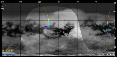 |
|
Image courtesy NASA/JPL/Space Science Institute |
The above image shows the ground trace of the Titan-31 flyby on a mosaic of Titan's surface, for a period of 32 hours around closest approach. The colour of the trace indicates Cassini's altitude above the surface. Blue: > 100 000 km, green: < 100 000 km, light blue: < 50 000, yellow: < 10 000 km, orange: < 5000 km, red: < 2000 km (not reached during this flyby). The point of closest approach is marked T31. Cassini approaches Titan over the southern hemisphere, near latitude -15° (lower right in this image) at 16 hours before closest approach, and then continues to pass over Titan's northern hemisphere.
