Titan Flyby - 2 October 2007
1 October 2007
Thirty-two days after Cassini's last flyby, the spacecraft revisits Titan for its thirty-seventh targeted encounter: Titan-36. The closest approach to the Saturnian moon occurs on Tuesday, 2 October, at 04:42:43 UT at an altitude of 975 kilometres above the surface and at a speed of 6.3 kilometres per second. The latitude at closest approach is 60° S and the encounter occurs on orbit number 50.This encounter is set up with two manoeuvres: an Iapetus encounter cleanup manoeuvre on 17 September, and a Titan approach manoeuvre on 28 September. Titan-36 is the second in a series of outbound encounters that will last until the end of the prime mission (mid 2008), and occurs less than two days after closest approach to Saturn. This is the first in a series of seven Titan southern hemisphere encounters.
Science Activities
- Cassini Radar (RADAR)
RADAR will have the opportunity to examine Titan's southern regions. The T36 flyby will reach similar latitudes to the southernmost previous RADAR observations on T7. The RADAR observations during T36 include inbound and outbound radiometry of terrain at low and mid latitudes; inbound and outbound scatterometry of Titan, including views of the Huygens landing site, inbound and outbound altimetry, and a short segment of high-altitude, low resolution SAR around 30° South. - Ion and Neutral Mass Spectrometer (INMS)
INMS allows RADAR to control the spacecraft pointing during closest approach, but RADAR is actually "riding along" while INMS takes observations close to Titan in order to determine the moon's atmospheric and ionospheric composition and thermal structure. These observations are part of the MAPS Titan campaign. - Ultraviolet Imaging Spectrograph (UVIS)
UVIS makes several slow scans across Titan's visible hemisphere to form spectral images. The objective is to obtain spectral images of Titan in the EUV and FUV to map the aurora and dayglow, to map hydrocarbon absorption, and to measure scattering and absorption by aerosols in the stratopshere. The UVIS slit will be scanned across Titan's disk to build up an image at many wavelengths. - Visual and Infrared Mapping Spectrometer (VIMS)
VIMS will capture global maps of Titan to study cloud evolution and seek other changes. - Imaging Science Subsystem (ISS)
ISS will monitor Titan via limited global-scale mosaics for surface and atmosphere changes. The imaging team will attempt to see surface colour variations, and monitor limb hazes. ISS had coverage of similar areas at higher resolution during the previous flyby (T35). Series of flybys that cover the same area repeatedly are useful for monitoring time dependent phenomena. These observations will allow us to see if, for instance, clouds are appearing or disappearing, if there are patterns in weather, or if the weather has any correlations with Titan's surface features. - Dual Technique Magnetometer (MAG)
MAG successfully downlinked data from the T7 flyby. By combining these with the data from the T36 flyby, the team will be able to look for temporal variations in Titan's magnetic field in the wake/south polar region.
Table of Events
22 September 2007
| Time UTC | Time wrt Titan-36 |
Activity |
| 20:51:00 | -09d 08h | Start of sequence S34 which contains Titan-36 |
28 September 2007
| Time UTC | Time wrt Titan-36 |
Activity |
| 11:36:00 | -03d 17h | OTM #130 prime. Titan-36 targeting manoeuvre |
29 September 2007
| Time UTC | Time wrt Titan-36 |
Activity |
| 04:06:00 | -03d 01h | OTM #130 backup |
30 September 2007
| Time UTC | Time wrt Titan-36 |
Activity |
| 11:28:40 | -01d 17h | Saturn periapse, R = 4.7 RS, lat = 5°, phase = 138° |
1 October 2007
| Time UTC | Time wrt Titan-36 |
Activity |
| 22:49:40 | -05h 53m | Descending ring plane crossing |
| 12:51:00 | -15h 51m | Start of the TOST segment |
| 12:51:00 | -15h 51m | Turn cameras to Titan |
| 13:21:00 | -15h 21m | Deadtime, 9 minutes and 43 seconds long. Used to accommodate changes in flyby time |
| 13:30:43 | -15h 12m | Titan atmospheric observations. Obtain information on CO, HCN, CH4. Integrate on disk at airmass 1.5-2.0 |
| 18:42:43 | -10h 00m | Titan atmospheric observations. Photometry observations of particle properties, vertical distributions ~6 km/px |
| 19:42:43 | -09h 00m | Titan atmospheric observations. EUVFUV imaging of Titan |
| 23:31:43 | -05h 11m | New waypoint |
| 23:53:43 | -04h 49m | RADAR observations. Radiometry |
2 October 2007
| Time UTC | Time wrt Titan-36 |
Activity |
| 02:42:43 | -02h 00m | RADAR observations. Scatterometry |
| 03:50:43 | -00h 52m | Transition to thruster control |
| 04:11:56 | -00h 31m | RADAR observations. Altimetry |
| 04:27:43 | -00h 15m | INMS/RADAR observations. SAR observations |
| 04:42:43 | +00h 00m | Titan-36 Flyby Closest Approach Time. Altitude = 975 km, speed = 6.3 km/s, 67°phase at closest approach |
| 15:09:14 | +10h 27m | Ascending ring plane crossing |
| 04:57:43 | +00h 15m | RADAR Observations. Altimetry |
| 05:12:43 | +00h 30m | Transition off of thruster control |
| 05:36:01 | +00h 54m | RADAR observations. Scatterometry |
| 06:42:43 | +02h 00m | RADAR observations. Radiometry |
| 09:32:43 | +04h 50m | New waypoint |
| 09:52:43 | +05h 10m | Titan surface observations. Regional map |
| 12:42:43 | +08h 00m | Titan surface observations. Global map |
| 13:22:43 | +08h 40m | Titan atmospheric observations. Photometry observations |
| 13:42:43 | +09h 00m | Titan atmospheric observations. Obtain information on CO, HCN, CH4. Integrate on disk at airmass 1.5-2.0 |
| 15:42:43 | +11h 00m | Titan surface and atmosphere observations. ISS NAC monitoring of surface and atmosphere |
| 17:42:43 | +13h 00m | Titan surface observations. Regional map |
| 18:42:43 | +14h 00m | Titan atmospheric observations. Obtain information on the thermal structure of Titan's stratosphere |
3 October 2007
| Time UTC | Time wrt Titan-36 |
Activity |
| 03:28:43 | +22h 46m | Deadtime, 22 minutes and 17 seconds long. Used to accommodate changes in flyby time |
| 03:51:00 | +23h 09m | Turn to Earth-line |
| 04:19:00 | +23h 37m | Playback of T36 data. Madrid 70M and 34M |
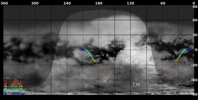
Titan Ground Trace
 |
|
Image courtesy NASA/JPL/Space Science Institute |
The above image shows the ground trace of the Titan-36 flyby on a mosaic of Titan's surface, for a period of 32 hours around closest approach. The colour of the trace indicates Cassini's altitude above the surface. Blue: > 100 000 km, green: < 100 000 km, light blue: < 50 000, yellow: < 10 000 km, orange: < 5000 km, red: < 2000 km. The point of closest approach is marked T36 (Cassini at 975 km altitude). Cassini approaches Titan over the equatorial region at 16 hours before closest approach (centre right in this image), and then continues to pass over Titan's southern hemisphere.
Observation Results
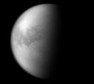
Cassini Instrument: Imaging Science Subsystem (ISS)
|
Date: 19 November 2007 Credit: NASA/JPL/Space Science Institute Image Notes: The dark, equatorial region known as Shangri-la is visible in this infrared composite view taken at 746 and 938 nm from 1.4 million km out. |
 |
