Titan Flyby - 20 December 2007
17 December 2007
On 20 December 2007, Cassini returns to Titan for its fortieth targeted encounter with the large moon: T39. The closest approach occurs at 22:57:55 UT at an altitude of 970 km above the surface with a relative speed of 6.3 kms-1. The latitude at closest approach is 70° S and the encounter occurs on orbit number 54.This encounter is set up with two manoeuvres: an apoapsis manoeuvre on 13 December, and a Titan approach manoeuvre, scheduled on 17 December. T39 is the fourth in a series of outbound encounters that will last until the end of the prime mission (mid 2008), and occurs less than two days after Saturn closest approach. This is also the fourth in a series of seven Titan southern hemisphere encounters.
Science Activities
- Cassini Radar (RADAR)
RADAR uses this opportunity to obtain South Pole coverage, including the first SAR coverage south of 70° south. The inbound leg features radiometry of unique terrain at high latitudes, scatterometry of Titan's southeast terrain, altimetry, and low rate SAR. Outbound observations include radiometry of unique northwestern terrain contiguous with that to be observed on the T43 flyby and scatterometry near the Huygens landing site. RADAR will return to the south pole area in the proposed extended mission, two years after this flyby; this allows the science team to look for changes over time; for instance, are Titan's lakes filling up? - Imaging Science Subsystem (ISS)
ISS monitors for surface and atmosphere changes of the bright area just to the north of the Adiri region, and it will be attempting to see surface colour variations and monitoring limb hazes. The instrument will also perform a full disk colour sequence at 1.4 km/pixel, and will take spectrophotometric low phase angle measurements of Rhea. - Composite Infrared Spectrometer (CIRS)
CIRS will obtain information on trace constituents in Titan's stratosphere and stratospheric temperatures. Vertical temperature and compositional profiles will be obtained via limb measurements. - Visible and Infrared Mapping Spectrometer (VIMS)
VIMS will create a regional and global map for continued monitoring of cloud formation and evolution. - Dual Technique Magnetometer (MAG)
T39 is a very close flyby over the southern polar region, passing through the outer flank. Good outer flank (away from Saturn) flybys have been missing until now. The outer flank feature will be an aspect of all coming flybys.
Table of Events
14 December 2007
| Time UTC | Time wrt Titan-39 |
Activity |
| 16:00:00 | -06d 07h | Start of sequence S36 which contains Titan-39 |
18 December 2007
| Time UTC | Time wrt Titan-39 |
Activity |
| 23:16:00 | -02d 24h | OTM #139 Prime. Titan-39 targeting manoeuvre |
19 December 2007
| Time UTC | Time wrt Titan-39 |
Activity |
| 03:35:36 | -01d 19h | Descending ring plane crossing |
| 05:04:29 | -01d 18h | Saturn periapse, R = 3.0 RS, lat = -13°, phase = 150° |
| 06:46:00 | -01d 16h | OTM #139 Backup |
20 December 2007
| Time UTC | Time wrt Titan-39 |
Activity |
| 08:16:00 | -14h 41m | Start of the TOST segment |
| 08:16:00 | -14h 41m | Turn cameras to Titan |
| 08:46:00 | -14h 11m | Deadtime, 16 minutes 55 seconds long. Used to accommodate changes in flyby time |
| 09:02:55 | -13h 55m | Titan atmospheric observations with VIMS. Cloud Map |
| 13:57:55 | -09h 00m | Titan atmospheric observations with CIRS. Obtain vertical profiles of temperatures in Titan's stratosphere |
| 17:51:55 | -05h 06m | New waypoint |
| 18:12:55 | -04h 45m | RADAR observations. Inbound radiometry of unique terrain at high latitudes contiguous with T43 |
| 21:27:55 | -01h 30m | RADAR observations. Scatterometry |
| 22:05:55 | -00h 52m | Transition to thruster control |
| 22:27:55 | -00h 30m | RADAR observations. Altimetry observations |
| 22:42:55 | -00h 15m | RADAR observations. Low rate SAR |
| 22:50:55 | -00h 07m | RADAR observations. High rate SAR |
| 22:57:55 | +00h 00m | Titan-39 Flyby Closest Approach Time Altitude = 970 km, speed = 6.3 kms-1, 61° phase at closest approach |
| 22:57:55 | +00h 00m | RADAR and INMS observations. SAR |
| 23:12:55 | +00h 15m | RADAR observations. Altimetry observations |
| 23:27:55 | +00h 30m | Transition off of thruster control |
| 23:51:55 | +00h 54m | RADAR observations. Scatterometry observations |
21 December 2007
| Time UTC | Time wrt Titan-39 |
Activity |
| 00:15:06 | +01 h18m | Ascending ring plane crossing |
| 00:29:55 | +01 h32m | RADAR observations. Radiometry |
| 03:42:55 | +04 h45m | New waypoint |
| 04:02:55 | +05 h05m | Titan atmospheric observations with CIRS. Obtain information on trace constituents in Titan's stratosphere. Integrate on limb at two positions |
| 07:57:55 | +09 h00m | Titan atmospheric observations with CIRS. Obtain information on CO, HCN, CH4. Integrate on disk at airmass 1.5-2.0 |
| 09:57:55 | +11 h00m | Titan surface and atmospheric observations with ISS. Monitoring for surface/atmosphere changes; attempt to see surface colour variations; monitor limb hazes, |
| 11:57:55 | +13 h00m | Titan surface observations with VIMS. Regional Map |
| 12:57:55 | +14 h00m | Rhea surface observations with ISS. Rhea north-polar spectrophotometry |
| 14:27:55 | +15 h30m | Titan surface observations with VIMS. Global Map |
| 23:12:55 | +01 d00h | Deadtime, 14 minutes 05 seconds long. Used to accommodate changes in flyby time |
| 23:27:00 | +01 d01h | Turn to Earth-line |
| 23:57:00 | +01 d01h | Playback of T39 data. Madrid 70 arrayed |
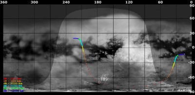
Titan Ground Trace
 |
|
Image courtesy NASA/JPL/Space Science Institute |
The above image shows the ground trace of the Titan-39 flyby on a mosaic of Titan's surface, for a period of 32 hours around closest approach. The colour of the trace indicates Cassini's altitude above the surface. Blue: > 100 000 km, green: < 100 000 km, light blue: < 50 000, yellow: < 10 000 km, orange: < 5000 km, red: < 2000 km. The point of closest approach (CA) is marked T39 (Cassini at 970 km altitude).
Observation Results
Cassini Instrument: Imaging Science Subsystem (ISS)
|
Date: 25 January 2008 Credit: NASA/JPL/Space Science Institute Image Notes: Titan's organic haze layers as seen by the narrow angle camera at the wavelength of 338 nm (ultraviolet) from a distance of 190 000 km |
 |
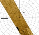
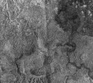
Cassini Instrument: Cassini Radar (RADAR)
|
Date: 8 January 2008 Credit: NASA/JPL Image Notes: Radar swath over Titan's south pole (< 84°S), revealing two radar-dark features in an area dominated by smooth valleys and rugged terrain. |
 |
|
Date: 8 January 2008 Credit: NASA/JPL Image Notes: Radar image of Titan, revealing evidence of flowing liquids. From sinuous, wide river channels to shorter, more chaotic drainage patterns. |
 |
