Titan Flyby - 5 January 2008
2 January 2008
Almost sixteen days after Cassini's last Titan flyby, the spacecraft revisits Saturn's largest moon for its forty-first targeted encounter: T-40. The closest approach to Titan occurs on Saturday, 5 January, at 21:30:20 UT at an altitude of 1010 kilometres above the surface and at a speed of 6.3 kms-1. The latitude at closest approach is 12° S and the encounter occurs on orbit number 55.This encounter is set up with two manoeuvres: an apoapsis manoeuvre on 29 December (cancelled), and a Titan approach manoeuvre, scheduled for 2 January. T40 is the fifth in a series of outbound encounters that will last until the end of the prime mission (mid 2008), and occurs less than two days after Saturn closest approach. This is also the fifth in a series of seven Titan southern hemisphere encounters.
Science Highlights
- Ion and Neutral Mass Spectrometer (INMS)
INMS takes observations at closest approach in order to determine atmospheric and ionospheric composition and thermal structure. These observations are part of the MAPS Titan campaign. - Visible and Infrared Mapping Spectrometer (VIMS)
VIMS performs high resolution spectral mapping (<5 km/pixel) of the area around the Huygens landing site at small solar phase angles, which will minimize airmass and maximize surface illumination. These images are part of the search for morphological features that will help understand Titan's geology. VIMS will also study cloud formation and evolution. The global monitoring that the VIMS has undertaken since the beginning of the mission will allow for constraining models of volatile transport. - Ultraviolet Imaging Spectrograph (UVIS)
UVIS will map atomic and molecular nitrogen, carbon and hydrogen in the high atmosphere. UVIS will also obtain vertical profiles of hydrocarbons and haze in Titan's mesosphere and upper stratosphere by observing the star Alpha Boötis (Arcturus) as it is occulted by Titan. - Imaging Science Subsystem (ISS)
ISS images regional and global maps on the dayside, and conducts a lightning and aurora search on the nightside prior to closest approach. - Composite Infrared Spectrometer (CIRS)
CIRS will look for stratospheric oxygen compounds during a far-IR limb observation. The instrument will also perform surface temperature mapping, stratospheric temperature mapping, and continue the search for trace species during a far-IR nadir integration. Each of these observations will be compared to similar ones in the early part of the mission to look for changes in temperatures and composition over time.
Table of events
14 December 2007
| Time UTC | Time wrt Titan-40 |
Activity |
| 16:00:00 | -22d 5h | Start of sequence S36 which contains Titan-40 |
2 January 2008
| Time UTC | Time wrt Titan-40 |
Activity |
| 22:18:00 | -02d 23h | OTM #142 prime. Titan-40 targeting manoeuvre |
3 January 2008
| Time UTC | Time wrt Titan-40 |
Activity |
| 22:05:45 | -01d 23h | Descending ring plane crossing |
| 22:11:10 | -01d 23h | Janus non-targeted flyby. Altitude = 118 251 km |
| 22:50:15 | -01d 23h | Daphnis non-targeted flyby. Altitude = 119 006 km |
| 23:11:15 | -01d 22h | Prometheus non-targeted flyby. Altitude = 112 497 km |
4 January 2008
| Time UTC | Time wrt Titan-40 |
Activity |
| 00:33:33 | -01d 21h | Pandora non-targeted flyby. Altitude = 122 840 km |
| 00:47:58 | -01d 21h | Saturn periapse, R = 4.0 RS, lat = -22°, phase = 143° |
| 07:18:00 | -01d 14h | OTM #142 Backup |
5 January 2008
| Time UTC | Time wrt Titan-40 |
Activity |
| 05:48:00 | -15h 42m | Start of the TOST segment |
| 05:48:00 | -15h 42m | Turn cameras to Titan |
| 06:18:00 | -15h 12m | Tethys observations with ISS. Tethys opposition surge |
| 07:18:00 | -14h 12m | New waypoint |
| 07:48:00 | -13h 42m | Deadtime, 19 minutes and 20 seconds long. Used to accommodate changes in flyby time |
| 08:07:20 | -13h 23m | Titan atmospheric observations with CIRS. Obtain information on CO, HCN, CH4. Integrate on disk at airmass 1.5-2.0 |
| 11:30:20 | -10h 00m | Titan atmospheric observations with ISS. WAC photometry. Particle properties, vertical distributions |
| 12:30:20 | -09h 00m | EUV-FUV imaging of Titan with UVIS. One slow scan across Titan's visible hemisphere to form spectral images. Stop for 20 minutes at the centre of the scan to image with ISS and VIMS, then continue the scan |
| 16:30:20 | -05h 00m | EUV-FUV imaging of Titan with UVIS. Slow scan across Titan's visible hemisphere to form spectral images |
| 18:30:20 | -03h 00m | WAC nightside imaging with ISS. Search for and monitor lightning/aurora |
| 19:30:20 | -02h 00m | Titan atmospheric observations with CIRS. Vertical sounding of stratospheric compounds on Titan, including H2O |
| 20:25:20 | -01h 05m | Transition to thruster control |
| 20:46:20 | -00h 44m | Titan atmospheric observations with UVIS. Titan occults Alpha Lyra |
| 21:02:20 | -00h 28m | New waypoint |
| 21:07:20 | -00h 23m | Titan atmospheric observations with VIMS. Titan Alpha Boötes occultation |
| 21:22:20 | -00h 08m | New waypoint |
| 21:25:20 | -00h 05m | MAPS TOST Campaign with INMS. Determine atmospheric and ionospheric composition and thermal structure |
| 21:30:20 | +00h 00m | Titan-40 Flyby Closest Approach Time. Altitude = 1010 km, speed = 6.3 kms-1, 38° phase at closest approach |
| 21:40:20 | +00h 10m | New Waypoint |
| 21:47:20 | +00h 17m | Titan surface observations with VIMS. High resolution mapping of the Huygens landing site |
| 22:06:20 | +00h 36m | Transition off of thruster control |
| 22:20:51 | +00h 50m | Ascending ring plane crossing |
| 22:27:25 | +00h 57m | New waypoint |
| 22:42:25 | +01h 12m | Titan surface observations with VIMS. High resolution imaging |
| 23:30:20 | +02h 00m | Titan surface observations with ISS. NAC regional map |
6 January 2008
| Time UTC | Time wrt Titan-40 |
Activity |
| 01:30:20 | +04h 00m | Titan atmospheric observationsv with CIRS. Obtain information on surface & tropopause temperatures, and on tropospheric CH4 |
| 02:30:20 | +05h 00m | Titan atmospheric observations with VIMS. Regional map |
| 04:30:20 | +07h 00m | Titan surface observations with ISS. NAC global map |
| 06:10:20 | +08h 40m | Titan atmospheric observations with ISS. WAC photometry. Particle properties, vertical distributions |
| 06:30:20 | +09h 00m | Titan atmospheric observations with CIRS. Obtain information on CO, HCN, CH4. Integrate on disk at airmass 1.5-2.0 |
| 11:30:20 | +14h 00m | Titan atmospheric observations with CIRS. Obtain information on the thermal structure of Titan's stratosphere. |
| 18:30:20 | +21h 00m | Titan atmospheric observations with CIRS. To obtain measurements of nitriles, hydrocarbons, and an oxygen compound, CO2, as a function of latitude and emission angle (at equator) on Titan |
| 21:44:20 | +01d00h | Deadtime, 11 minutes and 40 seconds long. Used to accommodate changes in flyby time |
| 21:56:00 | +01d00h | Turn to Earth-line |
| 22:26:00 | +01d 01h | Playback of T40 data. Madrid 70 arrayed |
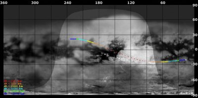
Titan Ground Trace
 |
|
Image courtesy NASA/JPL/Space Science Institute |
The above image shows the ground trace of the Titan-40 flyby on a mosaic of Titan's surface, for a period of 32 hours around closest approach (going from ~16° to ~234° longitude). The colour of the trace indicates Cassini's altitude above the surface. Blue: > 100 000 km, green: < 100 000 km, light blue: < 50 000, yellow: < 10 000 km, orange: < 5000 km, red: < 2000 km. The point of closest approach is marked T40 (Cassini at 1010 km altitude).
Observation Results
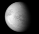
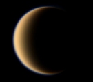
Cassini Instrument: Imaging Science Subsystem (ISS)
|
Date: 27 February 2008 Credit: NASA/JPL/Space Science Institute Image Notes: A bright streak of clouds is seen near 60° northern latitude at the top in this narrow-angle camera view using a combination of filters for polarized light |
 |
|
Date: 8 February 2008 Credit: NASA/JPL/Space Science Institute Image Notes: Wide-angle camera view of Titan (phase angle=128°) composed from three images taken through three filters in the red, green and blue spectral range |
 |
