Enceladus Flyby - 12 March 2008
12 March 2008
On 12 March 2008, Cassini visits Enceladus for the first time since the discovery of active geysers on this icy moon, two and a half years ago. The closest approach occurs at 19:06:12 UT at an altitude of just 52 kilometres above the surface and at a speed of 14.4 kilometres per second. This makes it Cassini's closest approach ever of Enceladus or any other Saturnian moon. The flyby occurs in orbit 61 of the mission.Cassini will approach Enceladus on a fast, inclined trajectory over the northern hemisphere and after closest approach (at 20° S, 135° W) will depart over the southern hemisphere. Approximately 58 seconds after closest approach, Cassini will cross the centre of the moon's plume, at an altitude of approximately 641 km. The plume of ice, gas and dust particles originates from geysers erupting from giant fractures on the south pole of Enceladus and is thought to be continuously refreshed. This flyby offers unique in-situ observations of the plume's chemical composition.
Coincidently, Enceladus will be in eclipse (in Saturn's shadow) for just over two hours (19:05:16-21:18:08 UT) starting near closest-approach.
Science Highlights
- Magnetospheric and Plasma Science (MAPS) group
The different MAPS instruments will examine the particle environment at 50 km from the surface to determine the nature of the material coming form the surface and its relationship to Saturn's E-ring, and to distinguish between two potential populations of particles: plume particles and sputtered particles from elsewhere on the surface.
- Cassini Plasma Spectrometer (CAPS). CAPS will make measurements to understand Enceladus as a plasma source. Because Cassini will fly deeper into the plume than in July 2005, in situ instruments will measure a larger signal. The predicted increase in count rates suggests that INMS can provide new results on plume composition.
- Ion and Neutral Mass Spectrometer (INMS). One of the main science goals of INMS will be to try and determine the compositional differences in the plume gas versus the gas produced from E-ring bombardment at other latitudes.
- Dual Technique Magnetometer (MAG). The close flyby distance will allow the magnetometer to determine whether Enceladus generates an induced magnetic field from a subsurface ocean. The magnetometer will also determine the composition of plume material from measurement of ion cyclotron waves in the magnetic field measurements - Visible and Infrared Mapping Spectrometer (VIMS)
VIMS will perform compositional mapping to determine the identity of volatiles, organics, and minerals, and place them within a geologic context - Imaging Science Subsystem (ISS)
ISS will image the surface of the cratered north polar terrain at up to 200 metre-scale resolution to determine the geologic history of Enceladus, including possible remnant tiger stripes; first good view of north polar regions (is all of it heavily cratered?) - Composite Infrared Spectrometer (CIRS)
During the flyby Enceladus will pass through Saturn's shadow (solar eclipse as seen from Enceladus). CIRS will make observations of the warm-up after solar eclipse to determine the heat capacity and textural properties of the moon's regolith; observations of hot spots and determination of any changes from the previous flyby - Ultraviolet Imaging Spectrograph (UVIS)
UVIS will obtain spectral images of Enceladus in the EUV (500-1100 Å) and FUV (1100-1900 Å) to map the surface composition, including water ice abundances and grain sizes, and will search for volatiles off the limb - Cassini Radar (RADAR)
RADAR will perform scatterometry of both hemispheres to determine cm-scale roughness and radiometry to understand the energy balance
Table of events
16 February 2008
|
Time UTC |
Time wrt |
Activity |
| 11:51:00 | -25d07h | Start of Sequence S38 which contains Enceladus-61 |
10 March 2008
|
Time UTC |
Time wrt |
Activity |
| 01:06:00 | -02d18h | OTM #148 Prime. Enceladus-61 approach targeting manoeuvre |
11 march 2008
|
Time UTC |
Time wrt |
Activity |
| 01:06:00 | -01d18h | OTM #148 Backup |
12 march 2008
|
Time UTC |
Time wrt |
Activity |
| 02:36:00 | -16h30m | Start of the SOST Segment |
| 03:31:12 | -15h35m | Inbound Enceladus ORS observations (distant). Images, compositional and temperature maps |
| 14:36:12 | -04h30m | Inbound Enceladus RADAR |
| 16:36:12 | -02h30m | Inbound ORS observations. Images and compositional maps |
| 17:13:12 | -01h53m | Inbound ORS observations. Images and compositional maps |
| 17:40:12 | -01h26m | ORS observations. Images, compositional maps |
| 18:07:12 | -00h59m | ORS observations. Images, compositional and temperature maps |
| 18:25:12 | -00h41m | ORS observations. Images and compositional maps of north pole region |
| 18:44:42 | -00h22m | MAPS prime observations. In-situ INMS and CDA measurements |
| 19:06:12 | +00h00m | Enceladus-61 Flyby Closest Approach Time. Altitude=52 km, speed=14.41 kms-1, high phase inbound, 136.5° phase at closest approach, mid phase outbound |
| 19:11:12 | +00h05m | CIRS observations with Enceladus in Saturn's shadow |
| 20:10:12 | +01h04m | Outbound Enceladus RADAR |
| 20:54:12 | +01h48m | CIRS observations during and after eclipse (which ends at 21:18:08 UT) |
| 22:01:12 | +02h55m | ORS observations (low-resolution). UVIS prime |
13 march 2008
|
Time UTC |
Time wrt |
Activity |
| 00:14:12 | +05h08m | Deadtime, 5 minutes long. Used to accommodate changes in flyby time |
| 00:20:00 | +05h14m | Turn to Earth |
| 00:51:00 | +05h45m | 9 hr data downlink with Goldstone 70M |
Observation Results
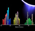
Instrument: Ion and Neutral Mass Spectrometer (INMS)
|
Date: 26 March 2008 Credit: NASA/JPL/SwRI Image Notes: Mass spectrum showing the chemical constituents sampled in Enceladus' plume as the spacecraft flew through it |
 |
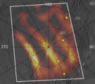
Instrument: Composite Infrared Spectrometer (CIRS)
|
Date: 26 March 2008 Credit: NASA/JPL/GSFC/SwRI/SSI Image Notes: Southpolar map of thermal radiation between 12-16μm, revealing its distribution along the fractures. Plume jet locations are indicated with yellow stars |
 |
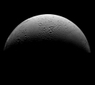
Instrument: Imaging Science Subsystem (ISS)
|
Date: 13 March 2008 Credit: NASA/JPL/Space Science Institute Image Notes: Highest resolution view yet of Enceladus' north polar region, showing older and more cratered surface enclosed by younger terrain |
 |
