Titan Flyby - 25 March 2008
25 March 2008
Today, Tuesday 25 March, Cassini returns to Titan for the mission's forty-third targeted encounter: Titan-42. The closest approach occurs at 14:27:48 UT, at an altitude of 1000 kilometres above the surface and at a speed of 6.3 kilometres per second. The latitude at closest approach is 27° S and the encounter occurs on orbit number 62.This encounter is set up with two manoeuvres: an apoapsis manoeuvre on 17 March and a Titan approach manoeuvre on 22 March. T42 is the seventh in a series of outbound encounters that will last until the end of the prime mission, and it occurs less than two days after Saturn closest approach. This is the last in a series of seven Titan southern hemisphere encounters.
Science Highlights
- Ion and Neutral Mass Spectrometer (INMS)
This will be the second time in the entire mission when INMS has used its open source neutral beaming mode to see reactive neutrals and understand wall effects, where detected particles end up sticking to the source. The instrument is unable to measure both ions and neutrals at the same time. Part of the Magnetosphere and Plasma Science Titan campaign, this observation will help sort out compositional changes of minor species during ingress vs. egress. - Visible and Infrared Mapping Spectrometer (VIMS)
VIMS rides along on the INMS closest approach observations using the noodle mode, where VIMS captures a long noodle-shaped swatch of Titan's surface. The noodle mode was first tried in the T20 flyby: the noodle observation, using a RADAR swath for context, showed correlation between interdune terrain and types of ices. If this particular observation is successful, VIMS scientists expect to exploit it more during the extended mission. Pointing is especially tricky for this mode. VIMS is not expected to capture the Huygens landing site, but will get medium resolution imaging of adjacent unknown territory. VIMS non-noodle prime observations during T42 include a mosaic at 5 kilometres per pixel of unknown territory at the northern rim of the dark units and cloud tracking. - Imaging Science Subsystem (ISS)
Similar to the T41 encounter, ISS captures regional mapping and full-disk mosaics covering Adiri and East Belet, giving one of the best views of the high northern latitudes and filling in coverage. The team is looking forward to seeing a high resolution image of a complex boundary in that northern region. The instrument may be able to see all the way up to the pole due to scattering by the atmosphere. In addition, the Narrow Angle Camera monitors for surface/atmosphere changes, attempts to see surface colour variations, and monitors limb hazes. As the geometries of the T41 through T44 flybys are very similar, it will be possible to monitor how the clouds change in this region every few weeks. - Composite Infrared Spectrometer (CIRS)
CIRS continues to extend spatial and temporal coverage of Titan, from low-spectral resolution disk maps to high spectral resolution nadir and limb integrations. Getting good time resolution is very important in the search for seasonal changes in the stratosphere, especially the expected break-up of the northern polar vortex in northern spring. - Radio and Plasma Wave Science (RPWS)
As Titan is out "in front" of Saturn, the T41 through T44 flybys put the spacecraft in an ideal location to have another opportunity to see Titan outside of Saturn's magnetosphere, in shocked solar wind ahead of the magnetosheath as happened on T32. It is interesting to duplicating the flyby geometry to look for shorter time-scale phenomena in Titan's plasma environment, so this series of four flybys, especially T41 through T43, will offer that opportunity.
Table of Events
22 March 2008
| Time UTC | Time wrt T-42 |
Activity |
| 16:50:00 | -02d 22h | OTM #151 prime. Titan-42 targeting manoeuvre |
23 March 2008
| Time UTC | Time wrt T-42 |
Activity |
| 01:50:00 | -02d 13h | Start of sequence S39 which contains Titan-42 |
| 10:20:05 | -02d 04h | Descending ring plane crossing |
| 10:36:48 | -02d 04h | Pallene non-targeted flyby. Altitude = 32 565 km |
| 10:54:37 | -02d 04h | Epimetheus non-targeted flyby. Altitude = 84 132 km |
| 11:24:18 | -02d 03h | Methone non-targeted flyby. Altitude = 102 556 km |
| 12:10:49 | -02d 02h | Saturn periapse, R = 3.7 RS, lat = -23°, phase = 149° |
24 March 2008
| Time UTC | Time wrt T-42 |
Activity |
| 00:20:00 | -01d 14h | OTM #151 backup |
25 March 2008
| Time UTC | Time wrt T-42 |
Activity |
| 01:35:00 | -12h 52m | Start of the TOST segment |
| 01:35:00 | -12h 52m | Turn cameras to Titan |
| 02:05:00 | -12h 22m | new waypoint |
| 02:05:00 | -12h 22m | Deadtime, 7 minutes and 48 seconds long. Used to accommodate changes in flyby time |
| 02:12:48 | -12h 15m | Titan atmospheric observations-VIMS. Cloud map |
| 05:27:48 | -09h 00m | Titan atmospheric observations-CIRS. Obtain information on trace constituents in Titan's stratosphere. Integrate on limb at two positions |
| 09:27:48 | -05h 00m | Titan atmospheric observations-CIRS. Obtain information on surface & tropopause temperatures, and on tropospheric CH4. Scan or contiguous steps across disk |
| 12:27:48 | -02h 00m | Transition to thruster control |
| 12:28:48 | -01h 59m | Titan atmospheric observations-CIRS. Vertical sounding of stratospheric compounds on Titan, including H2O. Integrations at 2 locations on the limb displaced vertically |
| 13:12:48 | -01h 15m | Titan atmospheric observations-CIRS. Vertical aerosol sounding of Titan's stratosphere |
| 13:37:48 | -00h 50m | Titan atmospheric observations-CIRS. Vertical temperature sounding of Titan's tropopause & stratosphere |
| 14:06:48 | -00h 21m | Turn cameras to new waypoint |
| 14:12:48 | -00h 15m | new waypoint |
| 14:12:48 | -00h 15m | Titan magnetosphere and plasma science campaign-INMS. Determine atmospheric and ionospheric composition and thermal structure |
| 14:27:48 | +00h 00m | Titan-42 Flyby Closest Approach Time. Altitude = 1000 km, speed = 6.3 kms-1, 21° phase at closest approach |
| 14:42:48 | +00h 15m | Turn cameras to new waypoint |
| 14:54:48 | +00h 27m | new waypoint |
| 14:54:48 | +00h 27m | Titan surface observations-VIMS. High Resolution Mapping of landing site |
| 15:09:42 | +00h 42m | Ascending ring plane crossing |
| 15:13:48 | +00h 46m | Transition off of thruster control |
| 15:35:48 | +01h 08m | Titan surface observations-VIMS. High-resolution cubes of Titan's surface |
| 16:27:48 | +02h 00m | Titan surface observations-ISS. High resolution regional map |
| 18:27:48 | +04h 00m | Titan atmospheric observations-CIRS. Obtain information on surface & tropopause temperatures, and on tropospheric CH4 |
| 19:27:48 | +05h 00m | Titan atmospheric observations-CIRS. Obtain vertical profiles of temperatures in Titan's stratosphere |
| 23:27:48 | +09h 00m | Titan atmospheric observations-CIRS. Obtain information on CO, HCN, CH4. Integrate on disk at airmass 1.5-2.0 |
26 March 2008
| Time UTC | Time wrt T-42 |
Activity |
| 01:27:48 | +11h 00m | Titan atmospheric observations-ISS. Monitoring for surface/atmosphere changes; attempt to see surface colour variations; monitor limb hazes, 1-3 km/px |
| 03:27:48 | +13h 00m | Titan surface observations-VIMS. Regional map |
| 04:27:48 | +14h 00m | Titan surface observations-VIMS. Global map |
| 15:34:48 | +01d 01h | Deadtime, 15 minutes and 12 seconds long. Used to accommodate changes in flyby time |
| 15:34:48 | +01d 01h | Turn to Earth-line |
| 16:20:00 | +01d 02h | Playback of T42 Data. Madrid 70 arrayed |
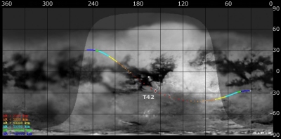
Titan Ground Trace
 |
|
Image courtesy NASA/JPL/Space Science Institute |
The above image shows the ground trace of the Titan-42 flyby on a mosaic of Titan's surface, for a period of 32 hours around closest approach (going from ~30° to ~243° longitude). The colour of the trace indicates Cassini's altitude above the surface. Blue: > 100 000 km, green: < 100 000 km, light blue: < 50 000, yellow: < 10 000 km, orange: < 5000 km, red: < 2000 km. The point of closest approach is marked T42 (Cassini at 1000 km altitude).
