Titan Flyby - 28 May 2008
27 May 2008
Wednesday, 28 May, Cassini returns to Titan for the mission's forty-fifth targeted encounter with Saturn's largest moon: Titan-44. The closest approach occurs at 08:24:32 UTC, at an altitude of 1400 kilometres above the surface and at a speed of 6.3 kilometres per second. The latitude at closest approach is 12.4° N and the encounter occurs on orbit number 69.T44 is the ninth in a series of outbound encounters and the last Titan encounter in the nominal four-year mission, or Cassini's Prime Mission. The extended mission, named the "Saturn Equinox Mission," will follow-up on the nominal mission this summer and will last two years. It includes 26 Titan flybys, as well as 7 Enceladus encounters, and one flyby each of the icy moons Dione, Rhea and Helene.
The T44 encounter is set up with two manoeuvres: an apoapsis manoeuvre on 21 May, and a Titan approach manoeuvre on 24 May. It occurs just over two days after Saturn closest approach.
Science Highlights
- Cassini Radar (RADAR)
T44 altimetry will be close to Hotei, over an area that was SAR imaged during the previous flyby, T43. The SAR swath sweeps northwest across Xanadu, over the Shangri-La dunefields and onto Dilmun. The SAR will image the southern edge of Xanadu, which shows a sharp boundary in microwave emissivity that is not presently understood. The SAR data is hoped to yield information on Xanadu's large-scale topography, as well as the influence of Xanadu on regional wind patterns as revealed in the dunes, and a partial overlap with T13 SAR may give stereo information and refine estimates of Titan's rotation state. - Ion and Neutral Mass Spectrometer (INMS)
INMS uses the RADAR orientation, and because of the higher altitude of this flyby the spacecraft is above most of Titan's ionosphere and INMS will obtain exospheric observations. The team will use these observations to identify what chemical compounds are escaping from Titan's atmosphere, looking at both altitude and the difference between the northern and southern hemispheres. - Composite Infrared Spectrometer (CIRS)
CIRS continues to extend spatial and temporal coverage of Titan, from low-spectral resolution disk maps to high spectral resolution nadir and limb integrations. Getting good time resolution is very important because we are looking for seasonal changes in the stratosphere, especially the expected break-up of the northern polar vortex in northern spring. In a rare occurrence, during the T44 targeted Titan flyby, CIRS will be observing the rings of Saturn. Usually, the Titan observations are considered more compelling during the flybys since the geometries and opportunities are so spectacular. These ring observations are therefore quite unique. CIRS will determine the mean thermal gradient across Saturn's many-particle-thick rings by executing radial scans of Saturn's main rings (A, B & C) over multiple illumination geometries (including phase, spacecraft inclination, and solar elevation) on the lit and unlit sides of the rings. - Visible and Infrared Mapping Spectrometer (VIMS)
VIMS observations concentrate on determining time scales for cloud formation and dissipation. - Imaging Science Subsystem (ISS)
The T44 flyby geometry shows a half-illuminated Titan as Cassini approaches and recedes. On approach ISS will carry out night-side imaging for photometry and will search for lightning and aurora. ISS will also acquire a regional-scale map of Hotei Arcus, its highest-resolution observation of this region to date. Outbound, ISS will see portions of Belet and Adiri and territory to the north, capturing global and full-disk mosaics. As the geometries of the T41 through T44 flybys are very similar, ISS has opportunities to detect clouds in this region every few weeks. - Radio and Plasma Wave Science (RWPS)
As Titan is out "in front" of Saturn, the T41 through T44 flybys put the spacecraft in an ideal location to have another opportunity to see Titan outside of Saturn's magnetosphere, in shocked solar wind ahead of the magnetosheath as happened on T32. We are interested in duplicating the flyby geometry to look for shorter time-scale phenomena in Titan's plasma environment, so this series of four flybys, especially T41 through T43, will offer that opportunity.
Table of events
19 April 2008
| Time UTC | Time wrt Titan-44 |
Activity |
| 07:18:00 | -39d 01h | Start of sequence S40 that contains Titan-44 |
24 May 2008
| Time UTC | Time wrt Titan-44 |
Activity |
| 19:58:00 | -03d 12h | OTM #157 prime, Titan-44 targeting manoeuvre |
25 May 2008
| Time UTC | Time wrt Titan-44 |
Activity |
| 22:05:42 | -02d 10h | Pallene non-targeted flyby. Altitude = 28 230 km |
| 22:14:24 | -02d 10h | Atlas non-targeted flyby. Altitude = 60 537 km |
| 22:15:09 | -02d 10h | Descending ring plane crossing |
| 22:49:36 | -02d 10h | Janus non-targeted flyby. Altitude = 63 900 km |
| 23:06:39 | -02d 09h | Saturn periapse, R = 4.293 RS, lat = -23°, phase = 150° |
26 May 2008
| Time UTC | Time wrt Titan-44 |
Activity |
| 19:43:00 | -01d 13h | OTM #157 backup |
27 May 2008
| Time UTC | Time wrt Titan-44 |
Activity |
| 04:43:00 | -01d 04h | Start of the TOST segment |
| 04:43:00 | -01d 04h | Turn cameras to Titan |
| 05:13:00 | -01d 03h | New waypoint |
| 05:13:00 | -01d 03h | Deadtime, 6 minutes and 32 seconds long. Used to accommodate changes in flyby time |
| 05:19:32 | -01d 03h | Rings observations - CIRS. Rings temperature |
| 07:44:32 | -01d 01h | Turn cameras to new waypoint |
| 08:19:32 | -01d 00h | New waypoint |
| 08:19:32 | -01d 00h | Titan atmospheric observations - CIRS. Obtain measurements of nitriles, hydrocarbons, and an oxygen compound, CO2, as a function of latitude and emission angle (at equator) on Titan |
| 10:24:32 | -22h 00m | Titan atmospheric observations - CIRS. Obtain information on the thermal structure of Titan's stratosphere |
| 16:24:32 | -16h 00m | NAC nightside imaging. Search for and monitor lightning/aurora |
| 17:24:32 | -15h 00m | Titan atmospheric observations - CIRS. Obtain information on CO, HCN, CH4. Integrate on disk at airmass 1.5-2.0 |
| 19:24:32 | -13h 00m | Titan surface observations - VIMS. Cloud map |
| 23:24:32 | -09h 00m | EUV-FUV imaging of Titan. Several slow scans across Titan's visible hemisphere to form spectral images |
28 May 2008
| Time UTC | Time wrt Titan-44 |
Activity |
| 05:24:32 | -03h 00m | WAC nightside imaging. Search for and monitor lightning/aurora |
| 06:24:32 | -02h 00m | Transition to thruster control |
| 06:25:32 | -01h 59m | Turn cameras to new waypoint |
| 06:33:32 | -01h 51m | New waypoint |
| 06:33:32 | -01h 51m | Titan surface observations - RADAR. Inbound scatterometry |
| 07:54:32 | -00h 30m | Titan surface observations - RADAR. Inbound altimetry |
| 08:09:32 | -00h 15m | Titan surface observations - RADAR. Inbound low rate SAR |
| 08:17:32 | -00h 07m | Titan surface observations - RADAR. High rate SAR |
| 08:24:32 | +00h 00m | Titan-44 Flyby Closest Approach Time. Altitude = 1400 km, speed = 6.3 kms-1, 21° phase at closest approach |
| 08:31:32 | +00h07m | Titan surface observations - RADAR. Outbound low rate SAR |
| 08:39:32 | +00h 15m | Titan surface observations - RADAR. Outbound altimetry |
| 08:57:30 | +00h 33m | Ascending ring plane crossing |
| 08:54:32 | +00h 30m | Transition off of thruster control |
| 09:16:32 | +00h 52m | Titan surface observations - RADAR. Outbound scatterometry |
| 10:03:42 | +01h 39m | Titan surface observations - RADAR. Outbound radiometry |
| 13:29:32 | +05h 05m | Turn cameras to new waypoint |
| 13:48:32 | +05h 24m | New waypoint |
| 13:48:32 | +05h 24m | Titan surface observations - ISS. NAC global map |
| 17:00:32 | +08h 36m |
Titan atmospheric observations-ISS. |
| 17:24:32 | +09h 00m | Titan atmospheric observations - CIRS. Obtain information on CO, HCN, CH4. Integrate on disk at airmass 1.5-2.0 |
| 19:24:32 | +11h 00m | NAC monitoring of surface and atmosphere. Monitoring for surface/atmosphere changes; attempt to see surface colour variations; monitor limb hazes |
| 21:24:32 | +13h 00m | Titan surface observations - VIMS. Regional map |
| 22:24:32 | +14h 00m | Titan surface observations - VIMS. Global map |
29 May 2008
| Time UTC | Time wrt Titan-44 |
Activity |
| 00:24:32 | +16h 00m | Deadtime, 22 minutes and 28 seconds long. Used to accommodate changes in flyby time |
| 00:47:00 | +16h 23m | Turn to Earth-line |
| 01:18:00 | +16h 54m | Playback of T44 data. Goldstone 70m |
| 03:18:00 | +18h 54m | Titan surface observations - VIMS. Global map |
| 12:12:00 | +01d 04h | Playback of T44 data. Madrid 70m |
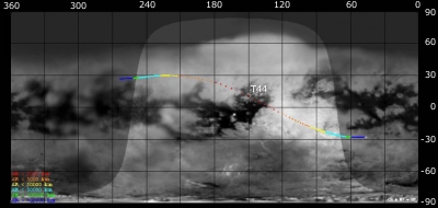
Titan Ground Trace
 |
|
Image courtesy NASA/JPL/Space Science Institute |
The above image shows the ground trace of the Titan-44 flyby on a mosaic of Titan's surface, for a period of 32 hours around closest approach (going from ~45° to ~264° longitude). The colour of the trace indicates Cassini's altitude above the surface. Blue: > 100 000 km, green: < 100 000 km, light blue: < 50 000, yellow: < 10 000 km, orange: < 5000 km, red: < 2000 km. The point of closest approach is marked T44 (Cassini at 1400 km altitude).
Observation Results
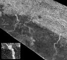
Cassini Instrument: Cassini Radar (RADAR)
|
Date: 8 August 2008 Credit: NASA/JPL Image Notes: Radar image of 450-km wide area at the edge of Xanadu (bright region at the top), at 15° S, 121° W, revealing several channels up to 5km wide. |
 |
